Santa Maria Volcano - Guatemala
Santiaguito Lava Dome Complex
Article by Jessica Ball
Santa Maria Volcano: Introduction
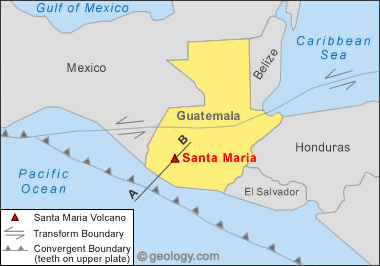
Santa María, a stratovolcano in the southwestern Guatemalan volcanic highlands, is the site of one of the twentieth century's largest eruptions. It is also the home of Santiaguito, one of the most active lava dome complexes in the world. The group of four lava domes formed at the foot of Santa María twenty years after the volcano's devastating 1902 eruption, and the domes have been growing ever since. The currently active dome, El Caliente, is the site of regular ash-and-gas explosions, and this minor but persistent activity has drawn many tourists to catch a glimpse of explosive silicic eruptions.| Map: Where is Santa Maria Volcano? |

| Map showing the location of Santa Maria Volcano in southwestern Guatemala. Map by Geology.com and MapResources. |
Santa Maria Volcano: Plate Tectonic Setting
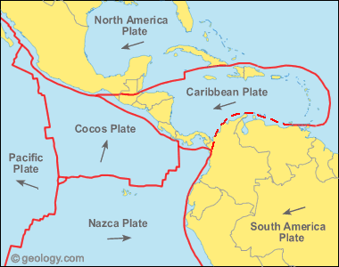
Santa María is located in the volcanic highlands of Guatemala, which parallel the Pacific coast of the country. The highlands were formed by the subduction of the Cocos plate under the Caribbean plate, which resulted in the formation of a line of stratovolcanoes that stretches along much of the Pacific coast of Central America. In Guatemala, these volcanoes overlie a basement of carbonate as well as igneous and metamorphic rocks; many xenoliths ("foreign" rock fragments) found in lavas erupted from the stratovolcanoes are composed of limestone, granite, and gneiss.| Simplified plate tectonics cross section (A to B) |

| Simplified plate tectonics cross-section showing how Santa Maria Volcano is located above a subduction zone formed where the Cocos and Caribbean plates collide. |
| Central America: Plate Tectonics Map |

| Plate tectonics map for Central America showing the convergence of the Cocos and Caribbean Plates responsible for Central American volcanism. Red lines are plate boundaries. Arrows show generalized directions of plate movement. Map by Geology.com and MapResources. |
| Facts About Santa Maria Volcano |
| Location: | Guatemala |
| Coordinates: | 10.463oN, 91.552oW |
| Elevation: | 3,772 m (12,375 ft) |
| Volcano Type: | Stratovolcano |
| Last Eruption: | (2010) Ongoing |
Santa Maria: Eruption History
There is no historical record of eruption at Santa María. The oldest lava flows that make up the volcano are ~30,000 years old, but there are few dates for younger deposits. Magnetic data suggests that most of the growth occurred during a 1000 to 3000 year period prior to 25,000 years ago, although more accurate dates are not yet available. The cone-building period was followed by a long period of quiescence interrupted by occasional small-volume lava flows from flank vents. (Conway et al, 1993)In November 1902, following several large earthquakes that caused significant damage in Guatemala and neighboring countries, Santa María experienced one of the biggest eruptions in the twentieth century. It lasted for several weeks, created an 0.5 km3 (0.1 mi3) crater in the volcano's south flank, and spread more than 5 km3 (1.2 mi3) of tephra as far away as Mexico. The eruption crater continued to be active for some months afterward, with several geysers erupting from a short-lived crater lake.
In 1922, new seismic activity heralded the eruption of a single dacitic lava dome in the 1902 crater. The dome, initially named Santiaguito, grew quickly, reaching 0.2 km3 (0.05 mi3) in only three years. A devastating dome collapse occurred in 1929, sending pyroclastic density currents down the river valleys below the domes; more than 3,000 people were killed and the plantations in the path of the pyroclastic flows were destroyed.
Following this collapse, activity at Santiaguito began to move westward from the original vent (now called Caliente), eventually forming three more lava domes (La Mitad, El Monje, and El Brujo) by the 1960s. From 1972-1975, both Caliente and El Brujo (the domes on either end of the complex) were active at the same time, producing lava flows, pyroclastic flows, and ash-and-gas eruptions. Activity has been restricted to the Caliente dome since 1975, and has included regular ash-and-gas eruptions from the dome summit as well as lava flows that travel down its flanks. Caliente has experienced several significant events since the 1929 dome collapse, including large eruptions and pyroclastic flows in 1973, 1989, and most recently in April of 2010.
| Santa Maria Eruption Layers |

| From the base of the domes, the alternating layers of lava flows and pyroclastic flow deposits are clearly exposed in the walls of the 1902 eruption crater in the cone of Santa María. Such layering is typical of stratovolcanoes, although the layers are rarely so regular and uninterrupted. Image © by Jessica Ball. Larger Image |
| Close-up of El Caliente ash-and-gas Eruption |

Close-up of an ash-and-gas eruption from the summit of El Caliente. The dome tends to erupt in this fashion every few hours, making it one of the best places to safely view an explosive volcanic eruption. Image © by Jessica Ball. Larger Image Picture of Santa Maria Volcano
Santa Maria Volcano Geology and HazardsFollowing the 1902 eruption, the dacitic lava domes of Santiaguito began forming in the crater. The dome complex has since grown to include four domes totaling more than 1 km3 (0.25 mi3) of material. The domes rise more than 500 meters (1,600 feet) above the base of the stratovolcano. While the main cone of Santa María is no longer active, the domes of Santiaguito have created a number of volcanic hazards since their growth began. The land around the volcano has been used for agriculture for centuries, especially coffee plantations, which puts the people living and working there in continual danger. The towns of El Palmar and San Felipe – which are located directly south of the domes – and the city of Quetzaltenango to the north of Santa María, are several places that often have to deal with hazards from the volcano. The bulk of the domes were built by the extrusion of lava flows and spines, but the dacite lava is so viscous that it poses no immediate hazard on eruption. Collapses of the spines, the tips of the lava flows, or larger portions of the domes themselves can, however, create dangerous pyroclastic flows; the collapse of material in eruption columns formed by ash-and-gas explosions can also create pyroclastic flows. Drifting ash from eruptions often lands on the towns and cities near the volcano, and can cause hazardous breathing conditions as well as damaging crops. Finally, lahars (volcanic mudflows) are an especially common hazard in the streams and rivers below the domes, since this area of Guatemala experiences an intense summer rainy season. Water falling on the slopes of Santa María and on the domes mixes easily with loose ash and rock and washes quickly downhill, choking the rivers below with mud and boulders. The original town of El Palmar was destroyed by lahars in the 1980s, and the new town could still be threatened by future mudflows.

Did You Know?• Many of the plantations near Santa María and Santiaguito grow coffee beans, which thrive in the rich volcanic soil (and seem to be relatively unaffected by the occasional ashfall). One of the major purchasers of these beans is Starbucks.• Halite – otherwise known as rock salt – can be found in eruptive deposits around Santa María, and is thought to come from beds of evaporites deep beneath the volcano.


|
--
(Gars O'Higgins Station penguins)
http://wiinterrr.blogspot.com/
http://penguinnewstoday.blogspot.com/
http://penguinology.blogspot.com/
(Twilight Saga commentary)
http://throughgoldeneyes.blogspot.com/
(Volcano/CalFire Watch)
http://www.netvibes.com/volcanowatch
One does not discover new lands without consenting to lose sight of the shore for a very long time.
-- Andre Gide
>^,,^<
__._,_.___
No comments:
Post a Comment