ka.txt
Keep-Alive Message
This is a Keep-Alive message to continue this Yahoo! Groups email list through slow messaging periods.
000.
------------------------------------
------------------------------------
[ Volcano ]
------------------------------------
Yahoo Groups Links
<*> To visit your group on the web, go to:
http://groups.yahoo.com/group/Volcano/
<*> Your email settings:
Individual Email | Traditional
<*> To change settings online go to:
http://groups.yahoo.com/group/Volcano/join
(Yahoo! ID required)
<*> To change settings via email:
Volcano-digest@yahoogroups.com
Volcano-fullfeatured@yahoogroups.com
<*> To unsubscribe from this group, send an email to:
Volcano-unsubscribe@yahoogroups.com
<*> Your use of Yahoo Groups is subject to:
https://info.yahoo.com/legal/us/yahoo/utos/terms/
Wednesday, May 31, 2017
[californiadisasters] On This Date In California Weather History (May 31)
2001: San Jose reported a high temperature of 101° F.
2001: Fresno reached 106° F, marking the 9th time this month the high reached into the triple digits.
This set a record for the most triple digit high temperatures in May.
2001: It was 93° F in Idyllwild, the highest temperature on record for May.
This also occurred on 5.29.1984.
It was 91° F in Palomar Mountain, the highest temperature on record for May.
This also occurred on 5.28.2003.
2001: Death Valley National Park recorded a high temperature of 118° F, setting a daily record.
1998: Fresno reached a high of only 85° F and in Bakersfield the high reached 84° F.
This was the warmest reading of the month at both locations and only the 3rd May on record in both cities that the high temperature never cracked 90° (also occurred in May 1917 and 1961).
1987: The Morse Wildfire burned 166 acres and destroyed 31 homes near Pebble Beach.
1971: 8" of snow fell at Glenbrook (east shore Lake Tahoe), its all-time record one-day total for May.
1910: Earliest 110° F high temperatures on record at Fresno and Bakersfield.
Also the highest temperatures ever recorded at both locations for May.
In Lemon Cove, the high reached a sweltering 118° F, the highest on record here in May.
Source: NWS San Francisco/Monterey, Hanford, Reno & San Diego
--
2001: Fresno reached 106° F, marking the 9th time this month the high reached into the triple digits.
This set a record for the most triple digit high temperatures in May.
2001: It was 93° F in Idyllwild, the highest temperature on record for May.
This also occurred on 5.29.1984.
It was 91° F in Palomar Mountain, the highest temperature on record for May.
This also occurred on 5.28.2003.
2001: Death Valley National Park recorded a high temperature of 118° F, setting a daily record.
1998: Fresno reached a high of only 85° F and in Bakersfield the high reached 84° F.
This was the warmest reading of the month at both locations and only the 3rd May on record in both cities that the high temperature never cracked 90° (also occurred in May 1917 and 1961).
1987: The Morse Wildfire burned 166 acres and destroyed 31 homes near Pebble Beach.
1971: 8" of snow fell at Glenbrook (east shore Lake Tahoe), its all-time record one-day total for May.
1967: 8" of snow fell at Sierraville.
1961: Virginia City, NV, recorded 1.9" of precipitation.
1910: Earliest 110° F high temperatures on record at Fresno and Bakersfield.
Also the highest temperatures ever recorded at both locations for May.
In Lemon Cove, the high reached a sweltering 118° F, the highest on record here in May.
Source: NWS San Francisco/Monterey, Hanford, Reno & San Diego
--

__._,_.___
Posted by: Kim Noyes <kimnoyes@gmail.com>
Be sure to check out our Links Section at http://groups.yahoo.com/group/californiadisasters/links
Please join our Discussion Group at http://groups.yahoo.com/group/californiadisasters_discussion/ for topical but extended discussions started here or for less topical but nonetheless relevant messages.
__,_._,___
[californiadisasters] File - Abbreviations & Meanings
Here is a list of internet abreviations and their meanings which will help you to better understand what others are saying and will give you some abreviated options for commonly used expressions and terms.
AAR At any rate
AAR can also mean "After Action Report", used in emergency management fields
AAS Alive and smiling
ADN Any day now
AEAP As early as possible
AFAIK As far as I know
AFK Away from keyboard
AISB As it should be
AOTA All of the above
ASAP As soon as possible
AWOL Absent Without Leave
B4 Before
B4N Bye for now
BAK Back at keyboard
BAU Business as usual
BBIAF Be back in a few
BBIAM Be back in a minute
BBL Be back later
BC Because or variously, Battalion Chief
BCNU Be seein' you
BFN Bye for now
BOL Best of luck
BRB Be right back
BTA But then again
BTW By the way
CHAOS Chief Has Arrived On Scene
CMIIW Correct me if I'm wrong
CMON Come one
CT CalTrans (California Department of Transportation)
CU See you
CUA See you around
CUL See you later
CUL8R See you later
CWYL Chat with you later
CYO See you online
DC Division Chief
DEGT Don't even go there
DIKU Do I know you?
DQMOT Don't quote me on this
DTS Don't think so
EM Emergency Management
EMA E-mail address
EOM End of message
F2F Face to face
FISH First in, still here
FAMCL Falling of my chair laughing
FC Fire Captain
FD Fire Department
FITB Fill in the blank
FM Fire Marshall
FUBAR Fudged Up Beyond All Recognition
FWIW For what it's worth
FYI For your information
GA Go ahead
GAL Get a life
GB Goodbye
GFI Go for it
GG Gotta Go
GIAR Give it a rest
GMTA Great minds think alike
GOL Giggling out loud
GR&D Grinning, running and ducking
GTRM Going to read mail
HAGN Have a good night
HAGO Have a good one
HHIS Head hanging in shame
HRU How are you?
HTH Hope this helps
IAC In any case
IAP Incident Action Plan
IB I'm back
IC I see, or variously Incident Command
ICP Incident Command Post
ICBW It could be worse
ICS Incident Command System
ICT Incident Command Team (CALFIRE term)
IDK I don't know
IDTS I don't think so
IIRC If I remember correctly
ILU I love you
ILY I love you
IM Instant message
IMHO In my humble opinion
IMNSHO In my not so humble opinion
IMO In my opinion
IMT Incident Management Team (USFS term)
INAL I'm not a lawyer
IOW In other words
IRMC I rest my case
ITA I totally agree
IUSS If you say so
IYKWIM If you know what I mean
IYO In your opinion
IYSS If you say so
JAC Just a sec
JIK Just in case
JJA Just joking around
JK Just kidding
KOTC Kiss on the cheek
KNIM Know what I mean?
L8R Later
LD Later, dude
LE Law Enforcement
LEO Law Enforcement Officer
LMAO Laughing my a** off
LOL Laughing out loud
LTM Laugh to myself
LTNS Long time no see
MorF Male or female?
MUSM Miss you so much
NBD No big deal
NIMBY Not in my back yard
NMH Not much here
NOYB None of your business
NN Night-Night
NP No problem
NRN No response necessary
NW No way
OIC Oh, I see
OEM Office Of Emergency Management
OES Office of Emergency Services
OMG Oh my God
OO Over and out
OOTD One of these days
OTOH On the other hand
OTTOMH Off the top of my head
PD Police Department
PDQ Pretty darn quick
PLMK Please let me know
PIMP Peeing in my pants
PMFI Pardon me for interrupting
PMFJI Pardon me for jumping in
POAHF Put on a happy face
PTL Praise the Lord
PXT Please explain that
PU That stinks!
RL Real life
RME Rolling my eyes
ROTFL Rolling on the floor laughing
RSN Real soon now
SMHID Scratching my head in disbelief
SNAFU Situation Normal ~ All Fudged Up
SO Sheriff's Office
SOMY Sick of me yet?
SOS Same Old Shtuff
SOTMG Short of time, must go
SPST Same place, same time
SSDD Same stuff, different day
ST or S/T Strike Team
STW Search the Web
SUITM See you in the morning
SUL See you later
SUP What's up?
SYL See you later
TAFN That's all for now
TAM Tomorrow a.m.
TC Take care
THX Thanks
TIA Thanks in advance
TLK2UL8R Talk to you later
TMI Too much information
TMWFI Take my word for it
TPM Tomorrow p.m.
TPTB The powers that be
TSDMF Tears streaming down my face
TTFN Ta ta for now
TTTT These things take time
TTYL Talk to you later
TTYS Talk to you soon
TU Thank you
TY Thank you
TYT Take your time
TYVM Thank you very much
UGTBK You've got to be kidding
UW You're welcome
WAM Wait a minute
WAYF Where are you from?
WB Welcome back
WIIFM What's in it for me?
WTC World Trade Center
WTG Way to go
WTH What the heck?
WTSHTF When the s*** hits the fan
WU? What's up?
WUF? Where are you from?
WWJD What would Jesus do?
WWYC Write when you can
WYSIWYG What you see is what you get
YBS You'll be sorry
YGBKM You gotta be kidding me
YW You're welcome
------------------------------------
------------------------------------
Be sure to check out our Links Section at http://groups.yahoo.com/group/californiadisasters/links
Please join our Discussion Group at http://groups.yahoo.com/group/californiadisasters_discussion/ for topical but extended discussions started here or for less topical but nonetheless relevant messages.
------------------------------------
Yahoo Groups Links
<*> To visit your group on the web, go to:
http://groups.yahoo.com/group/californiadisasters/
<*> Your email settings:
Individual Email | Traditional
<*> To change settings online go to:
http://groups.yahoo.com/group/californiadisasters/join
(Yahoo! ID required)
<*> To change settings via email:
californiadisasters-digest@yahoogroups.com
californiadisasters-fullfeatured@yahoogroups.com
<*> To unsubscribe from this group, send an email to:
californiadisasters-unsubscribe@yahoogroups.com
<*> Your use of Yahoo Groups is subject to:
https://info.yahoo.com/legal/us/yahoo/utos/terms/
[californiadisasters] File - California Disasters DISCUSSION GROUP
Extended discussion threads, chit-chat with other group members or slightly off-topic messages should be posted to the California Disasters DISCUSSION group, which can be found here:
http://groups.yahoo.com/group/californiadisasters_discussion/
All members are urged to join this sister-group and use it to post messages that are not relevant to the purpose of the main list.
Thank you,
Moderator
------------------------------------
------------------------------------
Be sure to check out our Links Section at http://groups.yahoo.com/group/californiadisasters/links
Please join our Discussion Group at http://groups.yahoo.com/group/californiadisasters_discussion/ for topical but extended discussions started here or for less topical but nonetheless relevant messages.
------------------------------------
Yahoo Groups Links
<*> To visit your group on the web, go to:
http://groups.yahoo.com/group/californiadisasters/
<*> Your email settings:
Individual Email | Traditional
<*> To change settings online go to:
http://groups.yahoo.com/group/californiadisasters/join
(Yahoo! ID required)
<*> To change settings via email:
californiadisasters-digest@yahoogroups.com
californiadisasters-fullfeatured@yahoogroups.com
<*> To unsubscribe from this group, send an email to:
californiadisasters-unsubscribe@yahoogroups.com
<*> Your use of Yahoo Groups is subject to:
https://info.yahoo.com/legal/us/yahoo/utos/terms/
[californiadisasters] File - Too Many Messages?
This group frequently has a HIGH MESSAGE VOLUME during major incidents.
If you feel you are getting too many messages, you can change your settings to receive less mail. Instead of receiving Individual Email, you can choose one of the following options:
Daily Digest:
This is the option to choose if you want to see all messages but limit the amount of email you receive. Yahoo will compile up to 25 group messages and send it in a single email to your inbox.
How to do this:
Go to <http://groups.yahoo.com/group/californiadisasters/join>
Under "Step 2. Message Delivery", select "Daily Digest". Scroll down and hit "Save Changes".
Special Notices:
You will not receive group emails except infrequent, important notices from the group moderators. You can still check the group messages on the group home page if you like but will not get them sent to your inbox.
Go to <http://groups.yahoo.com/group/californiadisasters/join>
Under "Step 2. Message Delivery", select "Special Notices". Scroll down and hit "Save Changes".
NOTE: Please do NOT select "Web Only"-- we want to be able to reach you via Special Notice when there are important notifications.
If you have any questions, you can contact the moderators by sending an email to <californiadisasters-owner@yahoogroups.com> and we will be happy to assist you.
Thanks!
The Moderating Team
------------------------------------
------------------------------------
Be sure to check out our Links Section at http://groups.yahoo.com/group/californiadisasters/links
Please join our Discussion Group at http://groups.yahoo.com/group/californiadisasters_discussion/ for topical but extended discussions started here or for less topical but nonetheless relevant messages.
------------------------------------
Yahoo Groups Links
<*> To visit your group on the web, go to:
http://groups.yahoo.com/group/californiadisasters/
<*> Your email settings:
Individual Email | Traditional
<*> To change settings online go to:
http://groups.yahoo.com/group/californiadisasters/join
(Yahoo! ID required)
<*> To change settings via email:
californiadisasters-digest@yahoogroups.com
californiadisasters-fullfeatured@yahoogroups.com
<*> To unsubscribe from this group, send an email to:
californiadisasters-unsubscribe@yahoogroups.com
<*> Your use of Yahoo Groups is subject to:
https://info.yahoo.com/legal/us/yahoo/utos/terms/
[Geology2] File - Rules
Attention Group!
Rule #1 is Rule #1 on all Yahoo groups: NEVER argue with a list-owner or list-moderator! This group is a benevolent dictatorship, NOT a democracy.
Rule #2 is to FOLLOW THE GOLDEN RULE: act as you wish others to act and treat others as you would like to be treated. Failure to follow the Golden Rule will result in our not following the Golden Rule with whomever breaks said Rule.
Rule #3 is there will be ABSOLUTELY NO spamming, trolling, flaming, whining, agitating, cussing or any other anti-social behavior. Violate this rule at the peril of your group membership!
Rule #4 is this group is a POLITICS-FREE and RELIGION-FREE zone. We'll impeach/excommunicate anybody who transgresses!
Rule #5 is STAY ON-TOPIC. We allow for a little bit of flexibility but don't force us to play the heavy and have to clamp down on this behavior.
Rule #6 is AVOID IDLE ON-LIST CHIT-CHAT. Remember there are hundreds of folks on this list and thus keep your posts focused on matters that might interest/edify the group as a whole.
Rule #7 is TRIM YOUR POSTS of excess lineage. Preferably only include the previous message you are responding to if you are indeed responding to previous post(s).
Rule #8 is bring any concerns or complaints you have about anything directly to the list-owners/list-moderators via an OFF-LIST message and DO NOT EVER take matters into your own hands in our stead!
Rule #9 is IF IN DOUBT ... DON'T! If you feel posting a particular remark or item could be a problem then don't do it at all or not until you ask us FIRST!
Rule #10 is USE EMOTICONS! Doing this will cut down on misunderstandings as email is not the best way for human beings to communicate as much nuanced communication such as facial expressions and voice tone are absent in this medium.
Rule #11 is give proper attribution to other groups if you forward to this group any information or a post from another group in part or in whole. It's the courteous thing to do!
------------------------------------
------------------------------------
------------------------------------
Yahoo Groups Links
<*> To visit your group on the web, go to:
http://groups.yahoo.com/group/geology2/
<*> Your email settings:
Individual Email | Traditional
<*> To change settings online go to:
http://groups.yahoo.com/group/geology2/join
(Yahoo! ID required)
<*> To change settings via email:
geology2-digest@yahoogroups.com
geology2-fullfeatured@yahoogroups.com
<*> To unsubscribe from this group, send an email to:
geology2-unsubscribe@yahoogroups.com
<*> Your use of Yahoo Groups is subject to:
https://info.yahoo.com/legal/us/yahoo/utos/terms/
[californiadisasters] On This Date In California Weather History (May 30)
2002: Thunderstorms dropped 1.01" of rain at the Hanford Airport in just 21 minutes in the afternoon resulting in street flooding in the city.
In just an hour, some 260 lightning strikes were recorded in the central and southern San Joaquin Valley.
2001: Ben Lomond had a high temperature of 105° F.
1991: China Lake NAS clocked an 89 mph gust from the west, tied for the highest on record here (also had an 89 mph gust on January 14, 1950).
1984: Remarkably, on the same day of the highest maximum and minimum temperatures, Borrego Springs also recorded its record rainfall for this day.
1984: Intense winds, gusting as high as 60 mph, blew across Kern County shattering windows, knocking air conditioning units off roofs and toppling trees.
A number of utility poles also were knocked down, some which were leveled by "a wall of wind and dust".
On this same date, Fresno only dropped to 76° F for low, making it the warmest minimum temperature on record for the month of May.
1983: Very heavy rain caused a mudslide on Slide Mountain (NV side of Lake Tahoe - north side of lake).
The resulting debris flow that was sent down Ophir Creek forced the closure of U.S. Highway 395.
1918: It was 32° F in Victorville, the latest date in the season with a freezing temperature on record.
Source: NWS San Francisco/Monterey, Hanford, Reno, Las Vegas, & San Diego
--
In just an hour, some 260 lightning strikes were recorded in the central and southern San Joaquin Valley.
2001: Ben Lomond had a high temperature of 105° F.
1991: High winds blasted Las Vegas, NV, darkening power for 100,000 customers, blowing over a large rocket sign at the Vegas World Casino and tearing off tips of turrets on the Excalibur.
1991: China Lake NAS clocked an 89 mph gust from the west, tied for the highest on record here (also had an 89 mph gust on January 14, 1950).
1984: Remarkably, on the same day of the highest maximum and minimum temperatures, Borrego Springs also recorded its record rainfall for this day.
1984: Intense winds, gusting as high as 60 mph, blew across Kern County shattering windows, knocking air conditioning units off roofs and toppling trees.
A number of utility poles also were knocked down, some which were leveled by "a wall of wind and dust".
On this same date, Fresno only dropped to 76° F for low, making it the warmest minimum temperature on record for the month of May.
1983: Very heavy rain caused a mudslide on Slide Mountain (NV side of Lake Tahoe - north side of lake).
The resulting debris flow that was sent down Ophir Creek forced the closure of U.S. Highway 395.
1918: It was 32° F in Victorville, the latest date in the season with a freezing temperature on record.
Source: NWS San Francisco/Monterey, Hanford, Reno, Las Vegas, & San Diego
--
__._,_.___
Posted by: Kim Noyes <kimnoyes@gmail.com>
Be sure to check out our Links Section at http://groups.yahoo.com/group/californiadisasters/links
Please join our Discussion Group at http://groups.yahoo.com/group/californiadisasters_discussion/ for topical but extended discussions started here or for less topical but nonetheless relevant messages.
__,_._,___
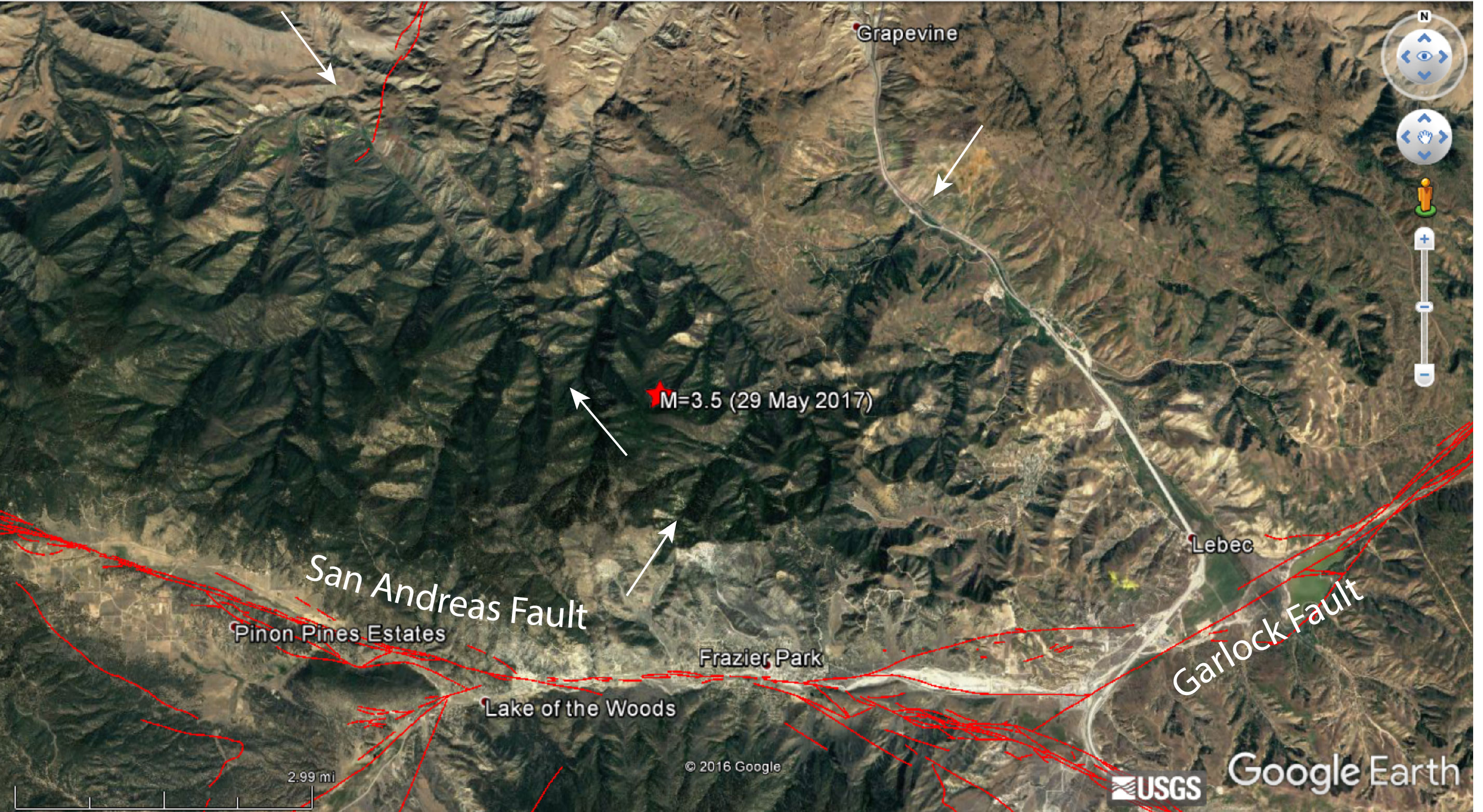
[Geology2] Small earthquake near the Big Bend of the San Andreas Fault
Small earthquake near the Big Bend of the San Andreas Fault
By David Jacobson, Temblor

Last night, at 9:14 p.m. local time, a M=3.5 earthquake struck just north of the San Andreas Fault in Southern California. The quake's epicenter was 5 km north of Frazier Park and near Tejon Pass on Interstate-5. While not large enough to cause damage, the earthquake did result in moderate shaking near the epicenter and approximately 150 reported feeling the quake on the USGS website. This earthquake occurred at an extremely shallow depth and was pure strike-slip in nature.

Because the epicenter of this quake was nearly 5 km from the main strand of the San Andreas, it likely did not occur on it. This idea is also supported by the fact that the two focal mechanism planes are not parallel with either the San Andreas, or the nearby Garlock faults. However, it should be pointed out that these planes are more optimally oriented, given the principle stress directions. So, while not on the main strands of either of these large faults, the structure on which last night's earthquake occurred, could be associated with them.
What this very small earthquake also highlights is potentially unmapped faults in the vicinity of the Big Bend section of the San Andreas. When a fault cannot relieve tectonic forces acting on it (such as when it is not optimally oriented), there have to be other faults that take accommodate it. In the Google Earth image below, the area around yesterday's earthquake is shown. While the San Andreas and Garlock faults are clearly mapped, there are extremely straight valleys, which have similar orientations to the focal mechanism of yesterday's quake.
Even though this earthquake likely didn't originate on the San Andreas, it is important to highlight this section of the fault given the potential for a large earthquake. Additionally, in Southern California, the Big Bend and adjacent Carrizo and Mojave sections of the San Andreas accommodate 50-70% of plate motion, meaning there is a very high seismic hazard. In a paper by Dr. Katherine Scharer at the USGS that was published earlier this year, she and her team found new evidence of at least 10 ground-rupturing earthquakes prior to the 1857 M=7.7-7.9 Fort Tejon earthquake along the Big Bend section of the Southern San Andreas Fault. In this paper, they determined that the average interval between earthquakes on the Big Bend section is approximately 100 years, with some as short as 22 years and as long as 186 years noted. Furthermore, 66% of the intervals are shorter than the current one, which sits at 160 years.
While we are not saying that a large earthquake along this section of the San Andreas is going to happen soon, based on historical seismicity, it is an area that is seen as more likely to rupture in a large earthquake than other parts of the San Andreas. Therefore, highlighting it and informing people of the seismic risk is vital to ensuring that when an earthquake does happen we can be are prepared as possible.

References
USGS
Scharer, K., R. Weldon, G. Biasi, A. Streig, and T. Fumal (2017), Ground-rupturing earthquakes on the northern Big Bend of the San Andreas Fault, California, 800 A.D. to present, J. Geophys. Res. Solid Earth, 122, doi:10.1002/2016JB013606. Link
--
Geology: @1roxxfoxx
Penguins: @wiinterrr
Wolves: @Canislupus101
Cats: @Furever_Home
__._,_.___
Posted by: Lin Kerns <linkerns@gmail.com>
__,_._,___
[Geology2] Deep in a South African gold mine, scientists drill for the heart of an earthquake

Near the bottom of the Moab Khotsong gold mine in South Africa, scientists aim to drill to the site of a recent earthquake.
HIROSHI OGASAWARA
Deep in a South African gold mine, scientists drill for the heart of an earthquake
It's no easy feat to drill into the faults that cause earthquakes. Intercepting such active ruptures, which are buried kilometers beneath the surface, requires specialized equipment, skilled crews, and a lot of money and time. There are no shortcuts. Well, maybe there's one: an express elevator in a South African gold mine that runs 3 kilometers straight into Earth.
This week, scientists were set to begin drilling a 750-meter-deep hole from the bottom of the Moab Khotsong mine, located some 180 kilometers southwest of Johannesburg, South Africa. Three years ago, a magnitude-5.5 earthquake erupted from a previously unknown fault beneath the mine. Aftershocks continue. The $1.6 million project, if successful, could reveal the internal workings of what may be a "fresh" fault: one that has experienced its first earthquake. Unsullied by previous quakes, the fault could yield new insights into how quakes unfold—and how humans can inadvertently trigger them.
The international project, dubbed Drilling into Seismogenic Zones (DSeis) and backed by the International Continental Scientific Drilling Program, is the brainchild of several Japanese researchers who have been working in South Africa since the fall of apartheid in 1991. Other efforts to drill into active faults, such as the San Andreas in California or the Alpine in New Zealand, have cost tens of millions of dollars and yielded one or two cores. In South Africa's mines, the researchers saw a quick and relatively cheap way to get a detailed look at the fracturing rock that generates earthquakes. "In Japan, we couldn't easily access the seismic source," says Yasuo Yabe, a geologist at Tohoku University in Sendai, Japan, fresh from a trip down the mine. "Here people are going in and out daily."
DSeis was already planning drilling projects in several other mines when the magnitude-5.5 Orkney earthquake struck beneath Moab Khotsong on 5 August 2014, killing one worker. The event kicked the project into high gear. It was the country's largest quake in nearly 50 years. South Africa's gold mines experience frequent small quakes triggered by their explosive excavations. But this one was far stronger and deeper; unlike most induced quakes it was not on the same level as the mine. The fault ran perpendicular to other known faults. And its rocks slid past each other horizontally—a strike-slip motion—rather than vertically, as in most smaller quakes.
These mysteries worried the mine companies, who need to plunge deeper for more gold and don't want seismic surprises. They were receptive to a pitch from a longtime collaborator, Hiroshi Ogasawara, a seismologist at Ritsumeikan University in Kusatsu, Japan, to add the Orkney fault to the list of DSeis targets.
Most campaigns to drill into earthquake zones have targeted faults like the San Andreas, which has seen thousands or millions of earthquakes. But there's good reason to believe, given its quiet tectonic environment, that the Orkney earthquake came from a fault that has ruptured just once or, at most, a few times, says DSeis collaborator William Ellsworth, a geophysicist at Stanford University in Palo Alto, California. Such a fault would lack the "rock flour" that builds up in active faults as they grind away and makes it hard to discern how an individual earthquake divides its energy into seismic waves, heat, strain, and pulverizing rock. "We have a tremendous opportunity to get a look at what is essentially an ordinary earthquake," Ellsworth says.
The mine is a challenging work environment. Moab Khotsong claims to be home to the world's deepest mine shaft: a 3000–meter descent at some 15 meters per second in a shaking cage, with only the arcs of head lamps piercing the darkness. At the drilling level, 95 floors down, it's a 10-minute ride in a rail carriage to the drill site. It can be eerily quiet, and the air carries an acrid scent of burnt rock and ammonia from recent dynamiting. "It's a smell that'd be associated with Hades," says Tullis Onstott, a geomicrobiologist at Princeton University who has also joined the project.
Onstott's goal is to learn whether earthquakes can favor the microbes that live in deep rock. In an experiment he's been trying to do for a decade, ever since it failed at a San Andreas drill site, he will install an automated sampling system, triggered by seismicity, in the borehole at the fault. Past work has shown that an earthquake can release a pulse of hydrogen gas, which might have been trapped in the rock or generated by chemical reactions caused by the fracturing. Onstott hopes, as more aftershocks strike, to discover a cascade of microbial populations feeding off this chemical energy. If so, similar faults could become targets for a search for life on Mars, which might influence the selection of a landing site for NASA's Mars 2020 rover mission, Onstott says.
Mine operators might also get what they are seeking: a clearer picture of how human activity can trigger quakes. In the United States, the underground disposal of wastewater from oil and gas drilling is known to trigger quakes by boosting pressure in the rock pores. Pore pressure is unlikely to be a factor in South Africa, says Ze'ev Reches, a geophysicist at the University of Oklahoma in Norman. But he notes that the Orkney quake, like some of the largest induced quakes in Oklahoma, occurred deep in basement rock along a previously unmapped fault. (Reches is planning to drill into a fault in Oklahoma, but he'll have to go 4.5 kilometers down.)
Plenty can still go wrong for DSeis. In May, operators shuttered another mine that the project planned to use, citing an increased risk of falling rocks. But Ogasawara says they have plenty of candidate earthquake faults for their campaign, including small, shallow ones accessible from nearby mines, which may allow them to target the very heart of an earthquake: the hypocenter, the exact place where a fault first starts to give way. "That is what we want to see," Ogasawara says. "We're expecting to show what a hypocenter looks like."
--
Geology: @1roxxfoxx
Penguins: @wiinterrr
Wolves: @Canislupus101
Cats: @Furever_Home
__._,_.___
Posted by: Lin Kerns <linkerns@gmail.com>
__,_._,___
[Geology2] Death by volcano?
Death by volcano?
- Date:
- May 30, 2017
- Source:
- Washington University in St. Louis
- Summary:
- The discovery of anomalously high levels of mercury in rocks from the Ordivician geological period has led to a new interpretation of the ensuing mass extinction. A sequence of disturbances may have led to catastrophic cooling by reflective sulfate aerosols injected into the atmosphere by massive volcanism. The finding is important since aerosol cooling is under consideration as a way to temper global warming.

Fike holds a 443-million-year-old slab of Ordovician limestone from Anticosti Island in Quebec that is sprinkled with the fossilized remains of marine creatures killed during a cooling pulse.
Credit: Jerry Naunheim Jr./WUSTL Photos
Anyone concerned by the idea that people might try to combat global warming by injecting tons of sulfate aerosols into Earth's atmosphere may want to read an article in the May 1, 2017 issue of the journal Geology.
In the article, a Washington University scientist and his colleagues describe what happened when pulses of atmospheric carbon dioxide and sulfate aerosols were intermixed at the end of the Ordivician geological period more than 440 million years ago.
The counterpart of the tumult in the skies was death in the seas. At a time when most of the planet north of the tropics was covered by an ocean and most complex multicellular organisms lived in the sea, 85 percent of marine animal species disappeared forever. The end Ordivician extinction, as this event was called, was one of the five largest mass extinctions in Earth's history.
Although the gases were injected into the atmosphere by massive volcanism rather than prodigious burning of fossil fuels and under circumstances that will never be exactly repeated, they provide a worrying case history that reveals the potential instability of planetary-scale climate dynamics.
Figuring out what caused the end Ordivician extinction or any of the other mass extinctions in Earth's history is notoriously difficult, said David Fike, associate professor of earth and planetary sciences in Arts & Sciences and a co-author on the paper.
Because the ancient atmospheres and oceans have long since been altered beyond recognition, scientists have to work from proxies, such as variations in oxygen isotopes in ancient rock, to learn about climates long past. The trouble with most proxies, said Fike, who specializes in interpreting the chemical signatures of biological and geological activity in the rock record, is that most elements in rock participate in so many chemical reactions that a signal can often be interpreted in more than one way.
But a team led by David Jones, an earth scientist at Amherst College, was able to bypass this problem by measuring the abundance of mercury. Today, the primary sources of mercury are coal-burning power plants and other anthropocentric activities; during the Ordivician, however, the main source was volcanism.
Volcanism coincides with mass extinctions with suspicious frequency, Fike said. He is speaking not about an isolated volcano but rather about massive eruptions that covered thousands of square kilometers with thick lava flows, creating large igneous provinces (LIPs). The most famous U.S. example of a LIP is the Columbia River Basalt province, which covers most of the southeastern part of the state of Washington and extends to the Pacific and into Oregon.
Volcanoes are plausible climate forcers, or change agents, because they release both carbon dioxide that can produce long-term greenhouse warming and sulfur dioxide that can cause short-term reflective cooling. In addition, the weathering of vast plains of newly exposed rock can draw down atmospheric carbon dioxide and bury it as limestone minerals in the oceans, also causing cooling.
When Jones analyzed samples of rock of Ordivician age from south China and the Monitor Range in Nevada, he found anomalously high mercury concentrations. Some samples held 500 times more mercury than the background concentration. The mercury arrived in three pulses, before and during the mass extinction.
But what happened? It had to have been an unusual sequence of events because the extinction (atypically) coincided with glaciation and also happened in two pulses.
As the scientists began to piece together the story, they began to wonder if the first wave of eruptions didn't push Earth's climate into a particularly vulnerable state, setting it up for a climate catastrophe triggered by later eruptions.
The first wave of eruptions laid down a LIP whose weathering then drew down atmospheric carbon dioxide. The climate cooled and glaciers formed on the supercontinent of Gondwana, which was then located in the southern hemisphere.
The cooling might have lowered the tropopause, the boundary between two layers of the atmosphere with different temperature gradients. The second wave of volcanic eruptions then injected prodigious amounts of sulfur dioxide above the tropopause, abruptly increasing Earth's albedo, or the amount of sunlight it reflected.
This led to the first and largest pulse of extinctions. As ice sheets grew, sea level dropped and the seas became colder, causing many species to perish.
During the second wave of volcanism, the greenhouse warming from carbon dioxide overtook the cooling caused by sulfur dioxide and the climate warmed, the ice melted and sea levels rose. Many of the survivors of the first pulse of extinctions died in the ensuing flooding of habitat with warmer, oxygen-poor waters.
The take-home, said Fike, is that the different factors that affect Earth's climate can interact in unanticipated ways and it is possible that events that might not seem extreme in themselves can put the climate system into a precarious state where additional perturbations have catastrophic consequences.
"It's something to keep in mind when we contemplate geoengineering schemes to mitigate global warming," said Fike, who teaches a course where students examine such schemes and then evaluate their willingness to deploy them.
Story Source:
Materials provided by Washington University in St. Louis. Original written by Diana Lutz. Note: Content may be edited for style and length.
Journal Reference:
- David S. Jones, Anna M. Martini, David A. Fike, Kunio Kaiho. A volcanic trigger for the Late Ordovician mass extinction? Mercury data from south China and Laurentia. Geology, 2017; G38940.1 DOI: 10.1130/G38940.1
Washington University in St. Louis. "Death by volcano?." ScienceDaily. ScienceDaily, 30 May 2017. <www.sciencedaily.com/releases/2017/05/170530082345.htm>.
--
Geology: @1roxxfoxx
Penguins: @wiinterrr
Wolves: @Canislupus101
Cats: @Furever_Home
__._,_.___
Posted by: Lin Kerns <linkerns@gmail.com>
__,_._,___