Wednesday, April 30, 2014

[Geology2] How Mexicans know when an earthquake is coming


How Mexicans know when an earthquake is coming

Apr 27th 2014, by T.W.

MEXICO CITY shook and rattled on April 18th, as a 7.2-magnitude earthquake sent people scurrying under tables for shelter. Tremors are a frequent scare for the city's 20m or so residents, who experience dozens of small shudders a year. But the panic is lessened by the fact that people know the earthquake is coming a couple of minutes before the ground starts to tremble. Before this month's big rumble, many Mexicans had already filed outside to await the wobble in safety, away from falling ceilings. Nowhere else in the world is able to forecast earthquakes in this way. How do the Mexicans do it?

In 1985 whole neighbourhoods of the capital were reduced to rubble by an almighty 8.1-magnitude terremoto, which flattened buildings all over the city. More than 10,000 people are reckoned to have been killed. The damage was devastating: parts of the city have yet to be rebuilt. The impact on society was greater still. Some historians believe it contributed to the end of the hegemony of the Institutional Revolutionary Party, whose incompetence in the aftermath of the earthquake undermined its claim to be the party that knew best how to govern. The scale of the disaster, and the ineptitude of the official response, galvanised civil society like never before. Mexico City's residents resolved that next time they would be prepared.

Within a few years they had come up with an ingenious early-warning system. The epicentre of earthquakes hitting Mexico City, which lies roughly in the centre of the country, is usually to the south, where the North American continental plate rubs up against the Cocos plate. This means that quakes are felt first in states such as Oaxaca, on the Pacific coast. So seismologists installed sensors in the south of the country that detect the first tremors and send a warning to the capital. The seismic wave moves at about 7,000 miles per hour. That sounds fast, but it means that it takes the quake nearly two minutes to travel the 200 miles from Oaxaca to Mexico City. Meanwhile the sensors' signal arrives virtually instantaneously in Mexico City, where alarms are sounded, giving people just enough time to scamper out into the street before the earthquake arrives.

Why can no other country develop an early-warning system like this? Japan has something similar, and California is trying to put one together. But they generally give much less time to take cover than in Mexico. The reason is that Japan and California—and indeed most earthquake-prone places—sit right on top of faultlines, so earthquakes strike moments after the first tremors are felt. Mexico City, by contrast, lies hundreds of miles away from the nearest fault, meaning that it takes a minute or two for the wave to arrive. A place so far away from a faultline would never normally be vulnerable, but Mexico City is built on a former lakebed, giving it jelly-like subsoil which amplifies even tiny tremors into mighty window-rattlers. The strength of its early-warning system, therefore, is built on the weakness of the city's foundations.

http://www.economist.com/blogs/economist-explains/2014/04/economist-explains-14
--


__._,_.___


__,_._,___

RE: [californiadisasters] Re: Wildfire - San Berdo Co./Nat'l Forest - Etiwanda Incident


no over 100 + now,,, burning to the south and west at this time,  squirrely winds..
,http://calfire.blogspot.com/  map of etiwanda fire ,, Joann


To: californiadisasters@yahoogroups.com
From: kimnoyes@gmail.com
Date: Wed, 30 Apr 2014 15:04:52 -0700
Subject: [californiadisasters] Re: Wildfire - San Berdo Co./Nat'l Forest - Etiwanda Incident


Now 800 acres.... more resources streaming in and staging further afield.... structures have burned in subdivisions. Evacs and closures in place.

Released: 14 min. agoNorth of Banyan between Rochester and Etiwanda Avenue
North of Wilson between Day Creek Wash and Etiwanda Avenue

Central Park is open as an evacuation shelter (11800 Base Line, Rancho Cucamonga)


On Wed, Apr 30, 2014 at 9:56 AM, Kim Noyes <kimnoyes@gmail.com> wrote:
Now 200 acres... evacs in place.


On Wed, Apr 30, 2014 at 9:33 AM, Kim Noyes <kimnoyes@gmail.com> wrote:
A hurricane-force Santa Ana Wind-driven wildfire is raging along the foothills above the Rancho Cucamonga area which has burned over 100 acres and all aircraft are grounded due to high winds..

Hotlist threads:
http://wlfhotlist.com/threads/39963-CA-BDF-Etiwanda?p=162488&posted=1
http://wlfhotlist.com/threads/39962-CA-BDF-Etiwanda

Live streaming TV:

KTLA ~ http://ktla.com/live/#axzz30O1l44Dt

KABC ~ http://abclocal.go.com/kabc/live
--


--


__._,_.___


Be sure to check out our Links Section at http://groups.yahoo.com/group/californiadisasters/links
Please join our Discussion Group at http://groups.yahoo.com/group/californiadisasters_discussion/ for topical but extended discussions started here or for less topical but nonetheless relevant messages.


__,_._,___

[Geology2] Landslide losses – raising the profile in the USA


24 April 2014

Landslide losses – raising the profile in the USA

Posted by dr-dave

4
Landslide losses in the USA

The two dramatic landslides of the last few weeks in the USA has undoubtedly raised the profile of this natural hazard.  The Oso landslide in Washington State remains high on the news agenda, and was even visited by the President earlier this week.  Meanwhile, the fascinating East Gros Ventre Butte landslide in Jackson Hole continues to creep, with devastating impacts on the family who owned the house at the crest of the slide.

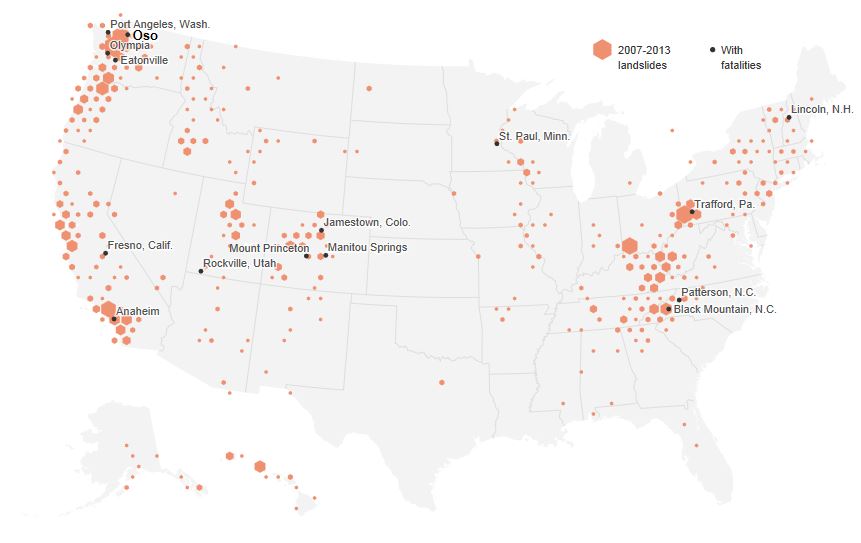
These two events have suddenly driven a new level of interest in landslide losses in the USA, which may be a good outcome from these tragic events.  National Geographic has produced a fantastic graphic illustrating the distribution of landslides across the USA since 2007:

…

This graphic uses data that Dalia Kirschbaum and colleagues at NASA have been collecting on landslide events around the world.  It shows reported landslides in the USA since 2007.  Note that the National Geographic page has more detailed explanations of the distribution of the observed landslides, so I won't attempt to repeat it here.  However, in general reported landslide incidence is highest where there is a combination of steep terrain, high rainfall, active tectonic processes and people.  Those four factors alone provide an explanation for most (but not all) of the landslides shown above.

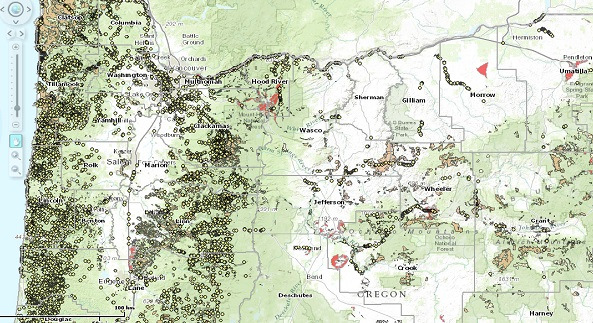
In addition, there has been increased interest in State and more local-level landslide inventories.  So, for example, this article describes the incidence of landslides in Oregon, and includes this map of landslides across the state:

landslide losses

KOIN6 and Oregon Department of Geology and Mineral Industries

…

A key issue in the US media is why there is no national scale landslide mapping programme in the USA – a good question!  In my view landslide work in the US has been grossly underfunded compared with other hazards (this article notes that the entire landslide programme at Federal Level costs $3.5 million per year – in comparison the Bingham Canyon landslide alone is thought to have cost about $1 billion), although the landslide teams at the USGS and elsewhere are world class.  In addition, there is little doubt that excellent and comparatively low cost landslide programmes at the State level have been killed off for political purposes.  A subsidiary question is whether warning systems in the most dangerous places could save lives.  The answer is of course yes – principles and techniques of landslide warning systems are well-established and have proven to be effective elsewhere.  They are however expensive and labour-intensive.  Unfortunately, both the Jackson Hole and Oso landslides will soon slip from the memory of most, and I fear that little will change.  Expect further hand-wringing when the next large event occurs – and given that we appear to be entering El Nino conditions, that may not be too far in the future.

Landslides are probably the most preventable of all natural disasters.  At a national level there is no excuse for failing to manage them properly.

http://blogs.agu.org/landslideblog/2014/04/24/landslide-losses-raising-the-profile-in-the-usa/

--


__._,_.___


__,_._,___

[Geology2] Volcanic Plume Over Southern Atlantic Ocean Revealed Through False-Color Imagery


The Moderate Resolution Imaging Spectroradiometer (MODIS) aboard NASA's Aqua satellite flew over the South Sandwich Islands on April 19, 2014 and acquired this false-color image of the cloudy scene.

Volcanic Plume Over Southern Atlantic Ocean Revealed Through False-Color Imagery

The South Sandwich Islands, in the far southern Atlantic Ocean, are often shrouded with thick cloud, making it difficult to view the region from space. Sometimes, however, the use of false-color imagery can be used to reveal events that would otherwise be obscured under cloud cover.

The Moderate Resolution Imaging Spectroradiometer (MODIS) aboard NASA's Aqua satellite flew over the South Sandwich Islands on April 19, 2014 and acquired this false-color image of the cloudy scene.

This false-color image uses a combination of non-visible (middle infrared and infrared) and visible (red) light captured in bands 7, 2, and 1, respectively, to distinguish clouds from snow and ice. Here the ice-covered islands appear bright turquoise, the clouds light turquoise and the water in the ocean appears deep black. Because the volcanic plume is a moist mixture of gas and ash, it reflects all three forms of light relatively well, so it appears nearly white.

In the north of this image, a thin plume of white rises from the volcano on Zavodovski island, the northernmost of the South Sandwich Islands and streams to the northeast. Further south, a wider white plume can be seen blowing across the Atlantic Ocean. This plume rises from the Mount Michael volcano, which is a young and frequently active stratovolcano located on Saunders Island, near the center of the South Sandwich Island chain.

The white plume from Mount Michael forms a chain of swirling eddies as it blows to the northeast. To the south, similar eddies can be seen behind three other islands. These are known as Von Kármán vortices. These vortices can form nearly anywhere that fluid flow is disturbed by an object. Because the atmosphere behaves like a fluid, when streaming air hits a blunt object, such as a mountain peak, the wind is forced around the object. The disturbance in the flow of the wind propagates downstream in a double row of vortices that alternate their direction of rotation, much like the eddies seen behind a pier in a river as water rushes past.

Image Credit: Jeff Schmaltz/MODIS Land Rapid Response Team, NASA GSFC

http://www.nasa.gov/content/volcanic-plume-over-southern-atlantic-ocean-revealed-through-false-color-imagery/#.U2GBtVe0J8G
--


__._,_.___


__,_._,___

[Geology2] USGS-Revised West Virginia, New Jersey and Georgia Maps Feature New Design


__._,_.___


__,_._,___

[californiadisasters] Re: Wildfire - San Berdo Co./Nat'l Forest - Etiwanda Incident


Now 800 acres.... more resources streaming in and staging further afield.... structures have burned in subdivisions. Evacs and closures in place.

Released: 14 min. ago

North of Banyan between Rochester and Etiwanda Avenue
North of Wilson between Day Creek Wash and Etiwanda Avenue

Central Park is open as an evacuation shelter (11800 Base Line, Rancho Cucamonga)


On Wed, Apr 30, 2014 at 9:56 AM, Kim Noyes <kimnoyes@gmail.com> wrote:
Now 200 acres... evacs in place.


On Wed, Apr 30, 2014 at 9:33 AM, Kim Noyes <kimnoyes@gmail.com> wrote:
A hurricane-force Santa Ana Wind-driven wildfire is raging along the foothills above the Rancho Cucamonga area which has burned over 100 acres and all aircraft are grounded due to high winds..

Hotlist threads:
http://wlfhotlist.com/threads/39963-CA-BDF-Etiwanda?p=162488&posted=1
http://wlfhotlist.com/threads/39962-CA-BDF-Etiwanda

Live streaming TV:

KTLA ~ http://ktla.com/live/#axzz30O1l44Dt

KABC ~ http://abclocal.go.com/kabc/live
--


--


__._,_.___


Be sure to check out our Links Section at http://groups.yahoo.com/group/californiadisasters/links
Please join our Discussion Group at http://groups.yahoo.com/group/californiadisasters_discussion/ for topical but extended discussions started here or for less topical but nonetheless relevant messages.


__,_._,___

RE: [californiadisasters] Wildfire - San Berdo Co./Nat'l Forest - Etiwanda Incident


no video live but it sure sounds like they are having problems with anchor points.
 

From: t_billman@hotmail.com
To: californiadisasters@yahoogroups.com
Subject: RE: [californiadisasters] Wildfire - San Berdo Co./Nat'l Forest - Etiwanda Incident
Date: Wed, 30 Apr 2014 12:09:43 -0700

sounds like x fires going now!
 

To: californiadisasters@yahoogroups.com
From: joalis76@hotmail.com
Date: Wed, 30 Apr 2014 11:40:11 -0700
Subject: RE: [californiadisasters] Wildfire - San Berdo Co./Nat'l Forest - Etiwanda Incident

 
and scanner link - http://www.broadcastify.com/listen/feed/15126/web  Joann over 200 ac + now


To: californiadisasters@yahoogroups.com
From: kimnoyes@gmail.com
Date: Wed, 30 Apr 2014 09:33:41 -0700
Subject: [californiadisasters] Wildfire - San Berdo Co./Nat'l Forest - Etiwanda Incident


A hurricane-force Santa Ana Wind-driven wildfire is raging along the foothills above the Rancho Cucamonga area which has burned over 100 acres and all aircraft are grounded due to high winds..

Hotlist threads:
http://wlfhotlist.com/threads/39963-CA-BDF-Etiwanda?p=162488&posted=1
http://wlfhotlist.com/threads/39962-CA-BDF-Etiwanda

Live streaming TV:

KTLA ~ http://ktla.com/live/#axzz30O1l44Dt

KABC ~ http://abclocal.go.com/kabc/live


__._,_.___


Be sure to check out our Links Section at http://groups.yahoo.com/group/californiadisasters/links
Please join our Discussion Group at http://groups.yahoo.com/group/californiadisasters_discussion/ for topical but extended discussions started here or for less topical but nonetheless relevant messages.


__,_._,___