Monday, December 29, 2014

[californiadisasters] Tree ring study shows California’s drought worst in 1,200 years


By Deanna Conners
on Dec 26, 2014

Tree ring study shows California's drought worst in 1,200 years

drought-tuolumneriver-ca-usgs-300

Scientists say California's drought is being driven by low (but not unprecedented) precipitation and record high temperatures.


Scientists studying the severe drought that has beleaguered California for the past three years estimate that this drought is the worst one in the past 1,200 years. The new estimate comes from data they compiled on tree ring growth and soil moisture. Low (but not unprecedented) precipitation and record high temperatures are the main factors driving this drought, the scientists say. An online edition of the journal Geophysical Research Letters published this work on December 3, 2014.

While droughts are relatively common in the western United States, the 2012 to 2014 drought in California has been particularly severe. During the drought, snow packs shrank to record low amounts and the water levels in many reservoirs plummeted to such low levels that several cities had to enforce water use restrictions to protect remaining water supplies. Officials at the National Weather Service are expecting drought conditions to improve somewhat with the recent rain, but say the drought will likely persist throughout the spring and beyond.
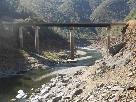
Low water levels in the Tuolumne River during the 2012–2014 California drought. Image Credit: USGS.

Low water levels in the Tuolumne River during the 2012–2014 California drought. Image via USGS.

To figure out just how unusual this drought is in comparison to past droughts in California, scientists from the University of Minnesota and the Woods Hole Oceanographic Institution compiled tree ring data from blue oaks to reconstruct the paleoclimate history of central and southern California. Blue oak trees, which are endemic to California, are very sensitive to a lack of moisture in the environment. In years with low moisture, the trees grow poorly and produce small growth rings. In contrast, the trees grow better during wet years, which results in larger growth rings.

Data from tree ring studies are important for analyzing drought events over hundreds to thousands of years because rainfall data from meteorological stations are not available for those times.
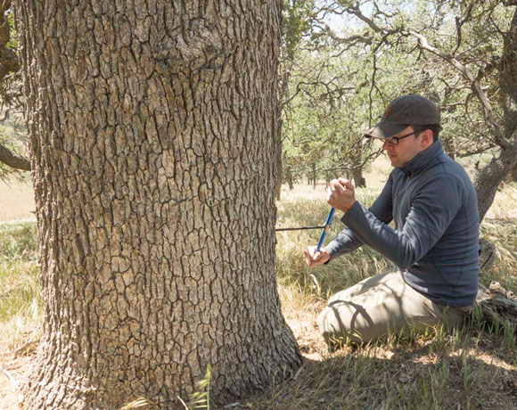
Kevin Anchukaitis collecting a tree ring sample from a blue oak in California. Image Credit: Dan Griffin.

Kevin Anchukaitis collecting a tree ring sample from a blue oak in California. Image Credit: Dan Griffin.

Daniel Griffin, lead author of the study, is an assistant professor in the Department of Geography, Environment and Society at the University of Minnesota. He commented on their methods in a press release:

California's old blue oaks are as close to nature's rain gauges as we get. They thrive in some of the driest environments where trees can grow in California.

Data from the oak trees showed that the current drought is the worst one in the past 1,200 years.

The severe drought in 2012–2014 appears to have been driven by a combination of low amounts of precipitation and high temperatures, the scientists say. While precipitation has been unusually low over the past few years, the amount of reduced rainfall is not unprecedented in California, and in the past, such events did not produce equally severe droughts. Thus, it is likely that recent record high temperatures exacerbated the severity of the current drought. Such droughts, which are sometimes called "hot droughts," are expected to become more frequent with climate change.

Kevin Anchukaitis, co-author of the study, is an assistant scientist at the Woods Hole Oceanographic Institution. He explained their findings as follows:

While it is precipitation that sets the rhythm of California drought, temperature weighs in on the pitch.

The research was funded by the National Oceanic Atmospheric Administration and Woods Hole Oceanographic Institute.

Bottom line: A new study based on tree ring growth that was published in the journal Geophysical Research Letters on December 3, 2014, estimates that the current California drought is the worst one in the past 1,200 years. Both low rainfall and record high temperatures are contributing to the severity this drought, the scientists say.

http://earthsky.org/earth/tree-ring-study-shows-californias-drought-worst-in-1200-years?utm


--


__._,_.___

Posted by: Lin Kerns <linkerns@gmail.com>


Be sure to check out our Links Section at http://groups.yahoo.com/group/californiadisasters/links
Please join our Discussion Group at http://groups.yahoo.com/group/californiadisasters_discussion/ for topical but extended discussions started here or for less topical but nonetheless relevant messages.


__,_._,___

[Geology2] Will Indonesia Be Ready for the Next Tsunami?


__._,_.___

Posted by: Lin Kerns <linkerns@gmail.com>


__,_._,___

Sunday, December 28, 2014

[Geology2] Government ups status, lahar warning


Government ups status,
lahar warning

The Jakarta Post, Jakarta | Headlines | Sun, December 28 2014
On the alert: A motorcyclist drives in Ternate city, North Maluku, on Saturday, with Mount Gamalama, which has shown increasing volcanic activity, visible in the background. (Antara/Widodo S. Jusuf)

Government volcanologists have raised the status of Mount Soputan in Minahasa, which straddles two regencies in North Sulawesi, while issuing a lahar-flow warning to people living near Mt. Gamalama in North Maluku and Mt. Merapi in Yogyakarta.

National Disaster Mitigation Agency (BNPB) spokesperson Sutopo Purwo Nugroho said the status of Mt. Soputan was raised a tier higher to alert, the second-highest level, as of Friday.

Sutopo said the local Volcanology and Geology Disaster Mitigation Center (PVBMG) reported white smoke reaching 50-200 meters high emitting from Soputan's crater and increased frequency of volcanic tremors. "We urge residents to not go within a 6.5-km radius of the crater," he said.

The BNPB said evacuations were not necessary as the nearest residential area was located 8 km from the crater.

With the increased warning level for Soputan, six volcanoes are now on alert status; the others are Mt. Gamalama in North Maluku, Mt. Slamet in Central Java, Mt. Sinabung in North Sumatra, and Mt. Karangetang and Mt. Lokon in North Sulawesi.

Mt. Lokon has been on alert status since July 2011, Mt. Karangetang since September 2013, Mt. Sinabung since April, Mt. Slamet since August and Mt. Gamalama since mid-December.

According to the agency's classification, the second-highest warning level indicates that a volcano has moved toward eruption, with seismic activities and related data showing that eruption or disaster resulting from its conditions is expected.

Following Mt. Gamalama's eruption last week, the Ternate Disaster Mitigation Agency (BPBD) issued a lahar-flood warning to residents of Ternate city, specifically those living near riverbanks.

"Rain has started falling in Ternate; there is possibility that lahar floods may occur like in 2011 and 2012," local BPBD head Hasyim Yusuf said as quoted by Antara news agency in Ternate on Saturday.

The volcano's eruption has resulted in volcanic ash piling up on the mountain's slope. The ash is expected to slide down into the rivers with rainfall.

Amid heavy rains on Thursday night, some residents in three subdistricts in North Ternate began preparing to evacuate as water containing volcanic material overflowed into the Tugurara River.

Hasyim said that although evacuations were not necessary, the agency called on the residents to remain cautious. Government officials and personnel had been notified to monitor river flows, he added.

The Yogyakarta Geological Disaster Investigation Agency has also issued a lahar warning to residents on the slope of Indonesia's most active volcano, Mt. Merapi.

The agency's officer Agus Budi Santoso said there was only a small possibility a lahar flood would occur.

"There is about 30 billion cubic material near Merapi's crater, which is quite small. The material has also hardened, making it more difficult to be flushed down by rain," Agus said.

With rainfall intensifying, residents living near riverbanks had been asked to remain cautious, he said.

Merapi, located on the border between Yogyakarta and Central Java provinces, last erupted in September 2013, spewing volcanic material reaching 2 km into the air.

http://www.thejakartapost.com/news/2014/12/28/government-ups-status-lahar-warning.html
--


__._,_.___

Posted by: Lin Kerns <linkerns@gmail.com>


__,_._,___

[Geology2] Mexico’s Popocatepetl volcano spews ash 3.5 km into sky


__._,_.___

Posted by: Lin Kerns <linkerns@gmail.com>


__,_._,___

[Geology2] Scientists study latest Yellowstone earthquake swarms


Scientists study latest Yellowstone earthquake swarms

5 hours ago  •  Associated Press

BOISE, Idaho — The latest earthquake swarm in central Idaho could help scientists better understand quake belts extending from Yellowstone National Park.

The most recent swarm in the Challis area started this week and so far 20 quakes have been recorded, the largest a magnitude 3.7 on Monday.

"There's obviously a fault down there at depth to produce these, and the town of Challis happens to be built on top of it," said scientist Mike Stickney of the Montana Bureau of Mines and Geology based in Butte, Montana. "We have no indication that it's leading to a larger event."

The quakes are occurring at the northern tip of the Lost River Fault but it's not clear if that fault is involved or if an unknown fault is at work. The Lost River Fault caused Idaho's largest recorded quake, a magnitude 6.9, rumbling in 1983 near 12,667-foot Borah Peak, Idaho's tallest peak.

Scientists brought in portable seismographs to monitor an earthquake swarm last summer. Most were removed after the swarm stopped but one was left in place.

It "completely stopped and then just a couple days ago it started up again," said Melanie Corrigan, a dispatcher with the Custer County Sheriff's Office. "People are just like, 'Oh, great, here we go again.'"

She said no damage has been reported.

Stickney said the quakes are being produced by different triggers, indicating a complex process that's poorly understood. The swarms are occurring within the Centennial Tectonic Belt extending west from Yellowstone National Park. The Intermountain Seismic Belt extends north and south from Yellowstone through multiple states.

The park is well known as a geologic hotspot, sitting atop magma. But scientists said that doesn't explain the earthquake swarms in Idaho.

"It clearly is somehow related," Stickney said. "I'm not blaming the belts on Yellowstone, but the fact that they extend into and out of Yellowstone is not a coincidence."

Also perplexing, scientists say, is that the earthquakes are so far from tectonic plates on the West Coast.

"That's the fundamental question that we don't know," Stickney said. "It's related to plate tectonics, but no one knows why this is occurring so far from a plate boundary. Nobody understands why these belts are located where they are."

Kris Pankow, associate director of the University of Utah Seismograph Stations, with Stickney earlier this month presented their findings about last summer's Challis Swarm, as it's called, to fellow scientists at the 2014 American Geophysical Union in San Francisco.

"It's interesting scientifically because there are so many things going on," Pankow said. "At what level you link these earthquakes I'm not sure."

She said she's mainly interested in the Idaho quakes as a way to better understand the Intermountain Seismic Belt. But so far, the Idaho quakes have been hard to figure out. Possible causes of the quakes include stretching of the crust or heated water moving about.

"I'm not sure which it is, to be honest, or it might be something completely different," she said.

She said there's still information to be analyzed from last summer's swarm, plus additional information from the latest swarm.

Challis residents are hoping not too much more information is produced.

"We don't have anything to do with it and we can't predict when the next one is going to happen," said Corrigan, the Custer County dispatcher. Residents "are kind of uneasy about it."

http://billingsgazette.com/news/state-and-regional/montana/scientists-study-latest-yellowstone-earthquake-swarms/article_1bb5cf26-3142-5c5a-95fc-b86db51ef01a.html

--


__._,_.___

Posted by: Lin Kerns <linkerns@gmail.com>


__,_._,___

[californiadisasters] California Drought Transforms Global Food Market


Drought in California

An estimated 82 percent of California is experiencing extreme drought, according to the U.S. Drought Monitor. Photographer: David Paul Morris/Bloomberg

California Drought Transforms Global Food Market

By Alan Bjerga August 11, 2014

For more than 70 years, Fred Starrh's family was among the most prominent cotton growers in California's San Joaquin Valley. Then shifting global markets and rising water prices told him that wouldn't work anymore.

So he replaced most of the cotton plants on his farm near Shafter, 120 miles northwest of Los Angeles, and planted almonds, which make more money per acre and are increasingly popular with consumers in Asia.

"You can't pay $1,000 an acre-foot to grow cotton," said Starrh, 85, crouching to inspect a drip irrigator gently gurgling under an almond tree.

Such crop switching is one sign of a sweeping transformation going on in California -- the nation's biggest agricultural state by value -- driven by a three-year drought that climate scientists say is a glimpse of a drier future. The result will affect everything from the price of milk in China to the source of cherries eaten by Americans. It has already inflamed competition for water between farmers and homeowners.

Growers have adapted to the record-low rainfall by installing high-technology irrigation systems, watering with treated municipal wastewater and even recycling waste from the processing of pomegranates to feed dairy cows. Some are taking land out of production altogether, bulldozing withered orange trees and leaving hundreds of thousands of acres unplanted.

"There will be some definite changes, probably structural changes, to the entire industry" as drought persists, said American Farm Bureau Federation President Bob Stallman. "Farmers have made changes. They've shifted. This is what farmers do."

Commodity Crops

In the long term, California will probably move away from commodity crops produced in bulk elsewhere to high-value products that make more money for the water used, said Richard Howitt, a farm economist at the University of California at Davis. The state still has advantages in almonds, pistachios and wine grapes, and its location means it will always be well-situated to export what can be profitably grown.

That may mean less farmland in production as growers abandon corn and cotton because of the high cost of water. Corn acreage in California has dropped 34 percent from last year, and wheat is down 53 percent, according to the USDA.

Cotton planting, Fred Starrh's one-time mainstay, has fallen 60 percent over the decade, while almonds are up by more than half.

'Big Deal'

On its own, California would be the world's ninth-largest agricultural economy, according to a University of California at Davis study. Shifts in its production reverberate globally, said Dan Sumner, another agricultural economist at the school.

"It's a really big deal," Sumner said. "Some crops simply grow better here than anyplace else, and our location gives us access to markets you don't have elsewhere."

The success of California agriculture was built in large part on advances in irrigation that allowed the state to expand beyond wheat, which flourishes in dry climates. It's now the U.S.'s top dairy producer and grows half the country's fruits, vegetables and nuts.

"Water has allowed us to grow more valuable crops," Sumner said. "Now, we have fruits and vegetables and North Dakota grows our wheat. Without irrigation, we'd be North Dakota."

An estimated 82 percent of California is experiencing extreme drought, according to the U.S. Drought Monitor. Agriculture has been hard hit as it consumes about four-fifths of the water that isn't set aside for environmental preservation. Some farmers are paying as much as 10 times more for water than what it cost before the drought.

Farmers Adapt

Another dry year in 2015 is a strong possibility, according to a study by the University of California at Davis released last month. The same study pegs drought-related farm losses at $1.5 billion, with 17,100 jobs lost statewide.

Groups such as the California Citrus Mutual and California Farm Bureau Federation have been calling for bigger allocations from the state's watersheds for agriculture, asking the state to add storage capacity and ease environmental regulations that set aside water to preserve endangered species.

California Governor Jerry Brown last week called for a $6 billion "no frills" bond measure for this November's election to boost water storage, a key demand of farmers that's smaller than what some groups want.

That puts the farmers on a collision course with environmentalists and urban advocates who say some choices -- such as a switch to almonds -- could worsen the scarcity.

Almond Crop

California grows four-fifths of the world's almonds, much of it for overseas markets. That has pushed the price up to more than $3 a pound, a record that has encouraged farmers to divert water from other crops.

Almonds use enough water to supply 75 percent of the state's population, according to Carolee Krieger, president and executive director of the California Water Impact Network, which supports bigger supplies for cities. Much of the crop is exported, meaning it isn't even feeding Californians, she said.

"Farmers should be profitable, but it can't come at the expense of urban water ratepayers," she said.

The U.S. Interior Department's Bureau of Reclamation, which supplies water to a third of the state's irrigated farmland, cut off California water distribution to some areas, while leaving others with 75 percent or less of their normal allocation.

Bulldozed Branches

Shawn Stevenson, who grows 1,200 acres of orange and olive trees outside Fresno, is in a zero-allocation area.

Unable to obtain affordable water for his trees, he hired a bulldozer to uproot about 400 acres of orange trees. He called his farm the "canary in the coal mine" for California agriculture, part of the 500,000 acres being abandoned this year, according to the University of California at Davis.

"We're going to deliver 25 percent of our volume this year," Stevenson said over the crunch of bulldozed branches. "That impacts the packing house, the people who sell the fruit, the people that we buy pesticides and fertilizers from."

"If this persists in the next year, the devastation we will see here and across the state will be biblical."

Faced with chronic dryness, farmers have been figuring out ways to adapt. Starrh's drip-irrigation system was pioneered in Israel and is now widely employed across California, cutting water use by supplying plants with smaller, targeted amounts.

Pepper Plants

"Farmers have done a remarkable job, scrambling around to get every piece of water they can," Sumner, the University of California economist, said. "They've taken water out of rice, out of alfalfa and moved it into onions and carrots and kept the trees and vines alive."

Will Terry grows peppers and strawberries in Ventura County, a region 60 miles west of Los Angeles that produces about $700 million of the fruit annually. The farm he runs with his father now uses about two-thirds of the water it used 20 years ago.

"People will try to grow the same things, but they'll have to change how they do it," said Terry as workers draped string across fields with which to hold up pepper plants.

Brad Scott, a dairy producer near Riverside in the Los Angeles suburbs, supplies his farm with treated municipal wastewater. The chlorine makes his ranch smell a bit like a swimming pool, but it has allowed his property to disconnect from the city water supply.

The disruption is worthwhile: Dairy prices reached an all-time high of $24.31 per hundred pound in April as export demand pushed dry-milk shipments to a record.

Spraying Animals

The drought has put special pressure on ranchers raising livestock, drying out pasture land and making it more costly to cool the herd by spraying the animals with water.

Brian Medeiros, a 26-year-old dairyman near Hanford, about 30 miles south of Fresno, is replacing the fields of corn and wheat he grows to feed his cows with sorghum and triticale, a heartier wheat and rye hybrid better suited for drought.

Medeiros drives past a shed containing almond hulls and distillers' dried grains -- the byproduct of ethanol and brewery production -- and citrus pulp, all of which he buys from nearby vendors to feed his cows. Leftover pomegranate has been a herd mainstay, though less so as the consumer craze for anti-oxidants has faded, reducing the number of suppliers.

He's also working with an engineer to create a cow-motion sensor. The system, deployed in his animal stalls, would change how animals are sprayed with water to keep them cool, ensuring that water only sprays while a cow is present.

Fewer Cherries

"You have to look at everything," Medeiros said between conversations in Portuguese with his father, who founded the farm, on his mobile phone.

A warmer climate is forcing Cindy Lashbrook to phase out cherries on the organic farm where she also grows walnuts, blueberries and other fruits and tree nuts near Merced, about 100 miles southeast of San Francisco.

Her cherries require 1,000 hours of temperatures under 45 degrees (7 degrees Celsius) between November and February, an amount her farm hasn't seen for several years. "We don't get the fog like we used to."

Howitt, of the University of California, said the drought means the state's farmers will have to permanently reduce water usage.

"California needs to rebalance its agricultural portfolio in response to this drought," Howitt said. "You will see more fallowing of land. We have to reduce our water footprint."

That means drip-fed trees for Starrh, a cotton-grower since when his family arrived on 30 acres in 1936 who now focuses on nuts.

And solar panels.

The Starrhs are leasing 480 acres to a sustainable-energy company on land that may never be watered again.

"It was good land for production," he said. "But reality dictates."

http://www.businessweek.com/news/2014-08-11/california-drought-transforms-global-food-market
--


__._,_.___

Posted by: Lin Kerns <linkerns@gmail.com>


Be sure to check out our Links Section at http://groups.yahoo.com/group/californiadisasters/links
Please join our Discussion Group at http://groups.yahoo.com/group/californiadisasters_discussion/ for topical but extended discussions started here or for less topical but nonetheless relevant messages.


__,_._,___
Newer Posts Older Posts Home