Shyhzerli volcano erupts due to earthquake in Azerbaijan

17 January 2014, 18:53 (GMT+04:00)
Baku, Azerbaijan, Jan. 17
By Ilhame Isabalaeva - Trend:
Eruption of the Shyhzerli volcano - one of the most active and largest mud volcanoes in Azerbaijan, occurred due to an earthquake, head of the Mud Volcanoes Department of Geology Institute of Azerbaijani National Academy of Sciences (ANAS), Professor Adil Aliyev told Trend on Jan. 17.
"The earthquake, which occurred at about 18 kilometres away from the volcano towards Shamakhi caused eruption of the Shyhzerli volcano. An earthquake occurred two or three days before the eruption," the scientist said.
The earthquake and the eruption did not occur on the same day, but sometimes such cases happen, Aliyev said.
"For example, 15 minutes after the Shamakhi earthquake that destroyed the city in 1902, there was a strong eruption of the Shyhzerli volcano. Such strong earthquakes result in the volcano erupting the same day. Volcanos may also erupt a day or two days after, when the seismic wave reaches it. We have found out that the volcano itself should be ready to erupt, there should be enough energy. The earthquake simply contributes to its eruption," the scientist said.
Currently the situation at the Shyhzerli volcano is stable, Aliyev said and noted that with the eruption the accumulated energy spilled out.
In 2013, two strong eruptions were registered in Azerbaijan - the Akhtarma-Pashaly volcano in Hajigabul district erupted in April and the Shyhzerli volcano in Gobustan district erupted on Dec. 20.
The Shyhzerli volcano has been erupting periodically since 1848, last year's eruption was the 23rd, the head of the department said.
Translated by E.A.
http://en.trend.az/news/society/2231322.html
~~~~~~~~~~~~~~~~~~~~~~~~~~~~~~~~~~~~~~~~~~~~~~~~~~~~~~~~~~~~~~


The country's National Disaster Reduction Commission said residents of Villa Canales, El Chupadero and Pacaya were relocated to San Vicente Pacaya, a town at a safer distance from Pacaya, one of the country's most active volcanoes.
Lava flows were said to be nearly 2,000 feet wide and 2 miles long just south of Guatemala City.
Small explosions and accompanying bursts of gas and ash were also produced by the restive volcano.
Guatemala has four active volcanoes that have caused catastrophic damage in the past.
The explosive eruption of Santa Maria in 1902 was one of the world's largest eruptions of the 20th century.
In 2010, a blast at Pacaya volcano coated the current capital, Guatemala City, in a thick layer of ash and rock. This forced hundreds of families to evacuate and officials to temporarily close the international airport.
Nearby Fuego (Fire) volcano sent pyroclastic flows of searing debris cascading down its slopes in May and June of 2012.
Photo: National Office for Disaster Reduction (Guatemala).
http://www.earthweek.com/2014/ew140117/ew140117d.html~~~~~~~~~~~~~~~~~~~~~~~~~~~~~~~~~~~~~~~~~~~~~~~~~~~~~~~~~~~~~~~~~~~~
Volcano Watch: Assembling Hawaii Island's volcanoes: Does size really matter?
Friday, January 17, 2014
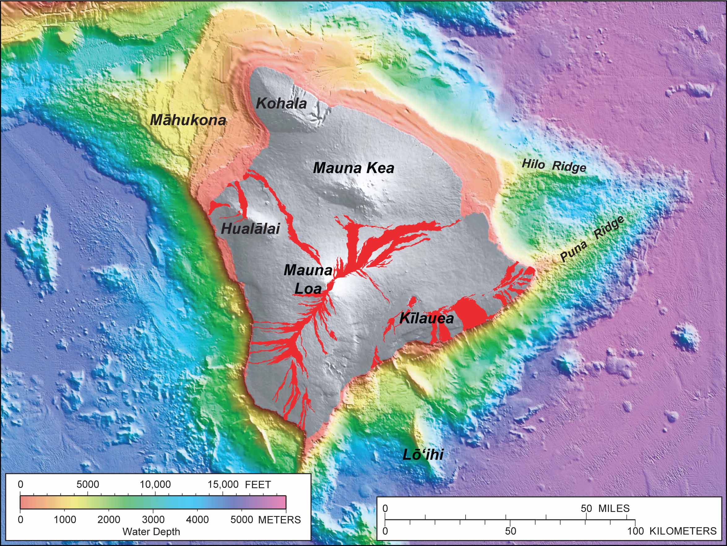
Colors ranging from red to purple indicate the water depth around the Island of Hawai'i, while shades of gray show land topography above sea level. Red shows lava flows erupted over the past 200 years. The Puna Ridge represents the submarine extension of Kīlauea's east rift zone. The Hilo Ridge, originally thought to be a rift zone of Mauna Kea, may, in fact, be connected to Kohala.
(Volcano Watch is a weekly article written by scientists at the U.S. Geological Survey's Hawaiian Volcano Observatory.)
In this second of four Volcano Watch articles addressing the "big" questions faced by volcanologists studying Hawaiian volcanoes today, we will focus on some notions about how the Island of Hawai'i may have been constructed.
In some ways, piecing together the Island of Hawai'i can seem quite straightforward. The island is made up of five volcanoes—Kohala, Hualālai, Mauna Kea, Mauna Loa, and Kīlauea. A sixth volcano, Māhukona, is located beneath the water off the island's northwest coast (Lō'ihi, off the southeast coast, is not part of Hawai'i Island). The volcanoes grew sequentially, beginning with Kohala, the oldest exposed volcano, which hasn't erupted in over 60,000 years. The youngest, Kīlauea, is currently erupting from two vents.
Calculating the size of the entire island is easy to do using maps of land- and sea-floor elevations. But how do you calculate the sizes of the individual volcanoes, which overlap with one another?
Consider Mauna Kea, which reaches 4,205 m (13,796 ft) in elevation and is the tallest volcano on the island (Mauna Loa is only about 35 m, or 120 ft, shorter). But is it really as "big" as it seems?
Off the southeast coast of Mauna Kea is the Hilo Ridge—a submarine ridge that extends 50 km (30 mi) offshore, much like Kīlauea's east rift zone and its submarine extension, the Puna Ridge. Early interpretations argued that the Hilo Ridge was a rift zone of Mauna Kea. The mapping of the ridge and determining its chemical composition, however, suggests a different association—that it very well may be a rift zone of the older Kohala volcano.
This alternative interpretation suggests that Mauna Kea is a smaller volcano perched on top of the older, more massive Kohala. In fact, Kohala may be as much as three times larger in volume than Mauna Kea. Ponder that on the next clear day, when the tallest point on the island can be seen from Hilo, Waimea, Waikōloa, and all points in between.
Likewise, there is disagreement over the size of Kīlauea. Submarine mapping of the south coast of Kīlauea has revealed rocks from Mauna Loa! This finding implies that Kīlauea has grown on the flank of the much larger Mauna Loa. But is Kīlauea merely a small bump on Mauna Loa's side or does it deeply cut into Mauna Loa's edifice, effectively wedging apart the older and larger volcano? The answer to this question has direct bearing on the eruptive activity that we should expect from Kīlauea in the future since volcano size and eruption rate are related.
We know that Kīlauea has been erupting vigorously for about 100,000 years. Yet its eruption rate over that period must be low if Kīlauea is considered to be a small volcano, since size and eruption rate are related. In this sense, the last several decades of continuous eruptive activity may be unusual (and might not continue far into the future).
If, on the other hand, Kīlauea is considered to be a large volcano, the eruption rate over the past 100,000 years must have been high, and the current eruptive activity would be normal. The same holds true for other volcanoes of Hawai'i Island—if we know their size, we can deduce their long-term eruption rates. This information is important, not only for understanding the evolution of Hawai'i's volcanoes, but also their hazard potential.
Clearly, scientists are still struggling to understand how Hawaiian volcanoes grow. How the volcanoes come apart is also an important issue and will be the topic of next week's Volcano Watch!
--

__._,_.___


No comments:
Post a Comment