California: King Fire near Pollock Pines
(UPDATE at 7:30 p.m. PDT, September 18, 2014)
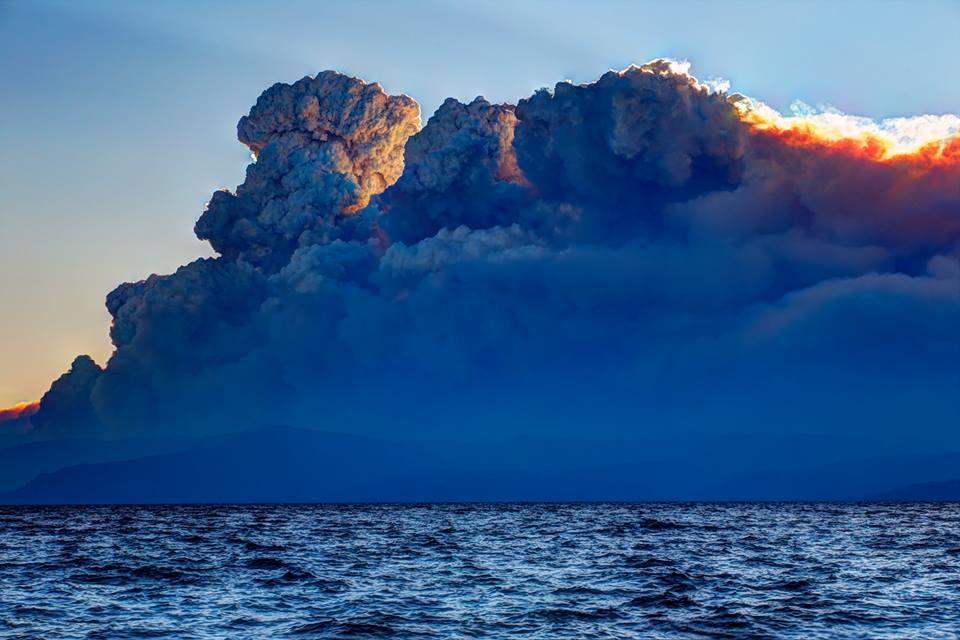
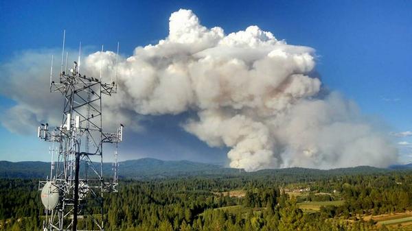
Pyrocumulus clouds over the King Fire, as seen Wednesday evening from Lake Tahoe, which was approximately 13 miles away from the fire very early Thursday morning. Photo via NWS Sacramento and Steve Ellsworth.
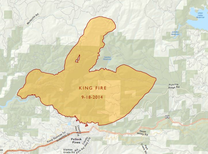
The incident management team has revised the size estimate for the King Fire, saying it has now burned 73,184 acres.
Now that the fire has burned into Placer County, it is threatening large hydroelectric facilities and recreation areas near reservoirs. One of the power stations operated by the Sacramento Municipal Utility District has been damaged, cutting off electricity delivery from the utility's network of reservoirs in the Sierra, according to the Sacramento Bee.
A person has been arrested and charged with arson for starting the King Fire.
****
(UPDATE at 2 p.m. PDT, September 18, 2014)
Below is a recent report from the incident management team describing the fire activity Wednesday night:
The fire continued to burn actively throughout the night. However: due to the day's extreme fire behavior, steep terrain, inaccessibility, variable wind direction, and darkness it was unsafe to approach the north portion of the fire to directly observe the fire behavior. [Through] field observations and Infrared imagery it was determined that the fire made a run of over ten miles to the north between the hours of 1600 and 0600. Spot fires were observed up to three miles ahead of the main fire front.
****
(UPDATE at 7:44 a.m. PDT, September 18, 2014)
King Fire almost triples in size
The photo of the pyrocumulus over the King Fire that we posted yesterday, below, was captured during a period when the fire was making a very large run to the northeast. On Wednesday the fire added 52,400 acres, growing from 18,544 acres to 70,944 acres, almost tripling in size in 24 hours, running for 16 miles through the El Dorado National Forest. It is now between Hell Hole and French Meadows Reservoirs in Placer County, 12 miles from Olympic Valley, 13 miles from the west shore of Lake Tahoe, and 20 miles from Truckee.
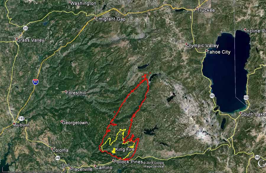
Map of the King Fire. The red line is the perimeter just after midnight early Thursday morning, 9-18-2014. The yellow line is from about 24 hours before. (click to enlarge)
Evacuations have affected 2,155 people. The El Dorado County Sheriff's web site has more details.
The fire is being fought by 3,700 personnel. Last year the 257,000-acre Rim Fire at Yosemite National Park had over 5,000 people assigned — this fire may come close to that personnel figure, especially if it continues to add over 50,000 acres a day.
Other resources assigned to the fire include 299 engines, 88 hand crews, 15 helicopters, 49 dozers, and 68 water tenders.
King Fire Information Line: (530) 647-5218
****
(UPDATE at 5:44 p.m. PDT, September 17, 2014)
The King Fire east of Placerville, California has been very active this afternoon, as evidenced by this huge pyrocumulus cloud over the convection column of smoke today.
****
(UPDATE at 8:10 a.m. PDT, September 17, 2014)
Map of King Fire 9-17-2014 (click to enlarge)
Above is a screen grab of the latest map of the King Fire east of Placerville, California. To see the full 742 KB .pdf map, download this file: King Fire map 2014_09_17 If you download the file, you may notice that the map is dated tomorrow, September 18. We're fairly certain it should read September 17. Evacuations are ongoing. The El Dorado County Sheriff's Office has the details.
Here is the latest information about the King Fire from the Incident Management Team Wednesday morning: Size: 18,544 acres based on an infrared mapping flight last night Containment: 5% Personnel: 2,519 Evacuations: 2,150 people Number of structures threatened: 1,632 Last night (Tuesday) the fire was active. Humidity recovery was exceptionally poor [the humidity remained low], but the fire did mostly stay on the ridge tops. The fire is expected to be active again today [Wednesday] due to expected gusty and erratic winds, mostly from the southwest. Fire growth is expected mostly to the N/NE.
****
(UPDATE at 2:20 p.m. PDT, September 16, 2014)
The Incident Management Team made this map available on the National Forest InciWeb page this afternoon:
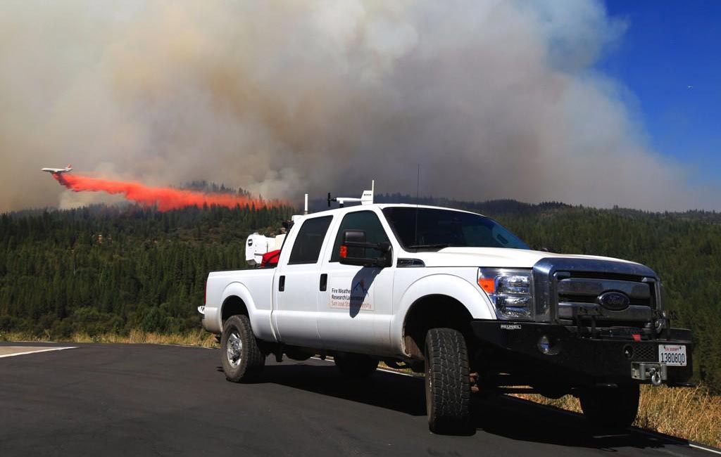
DC-10 dropping on the King Fire, September 16, 2014. Photo by San Jose State University Fire Weather Research Lab.
****
(UPDATE at 9:15 a.m. PDT, September 16, 2014)
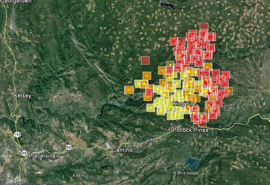
Map of the King Fire at 2:50 a.m. PDT, September 16, 2014. The squares represent heat detected by a satellite, accurate to within a mile or so. The red squares are the most recent. (click to enlarge)
The King Fire east of Placerville, California is requiring evacuations north of the community of Pollock Pines. Tuesday morning the fire is still spreading to the east and north and is listed at 11, 570 acres with 5 percent containment. The fire is burning in steep terrain located in the South Fork American River Canyon and Silver Creek Canyon. The fire started out as a CAL FIRE responsibility fire and later burned onto the El Dorado National Forest, so we may not see any good maps of the fire any time soon. Neither of the official sources of detailed information from CAL FIRE or the U.S. Forest Service have mentioned by 9:39 a.m. on Tuesday September 16 that 12 firefighters were overrun by the fire on Monday, deployed fire shelters, and had to run from the fire, eventually making it to a spot after a long run and hike where they could be extracted by helicopters. A dozer also burned in the incident. CAL FIRE sent out a tweet that briefly confirmed that the entrapment occurred.
****
(UPDATE at 4 p.m. PDT, September 15, 2014)
A CAL FIRE Captain and an inmate crew, 12 people total, were overrun by the fire and deployed their fire shelters. After initially deploying, they ran and later walked quite a distance, guided by the Helicopter Coordinator overhead in a helicopter, until they reached a point where they could be picked up by helicopters. No major injuries were reported, however it just occurred at about 1 p.m. today and not all the details are known. Three ambulances were requested to meet them at the airport where the helicopters landed. A dozer was also burned over. The operator was "accounted for"; no more details are available about the operator. More details are in another article.
****
(UPDATE at 9:20 a.m. PDT, September 15, 2014)
The King Fire 11 miles east of Placerville, California has been spreading rapidly with long-range spotting north of the community of Pollock Pines. There is a significant threat to the Whites Meadows, Spring Valley, Camino, and Pollock Pines communities. Areas under a mandatory evacuation order include White Meadows Road, Spring Valley Road, the eastside of Forebay Road from King of the Mountain Road to Pony Express Trail, and all roads north of Pony Express Trail from Forebay road east through Bullion Bend. Other areas are under a voluntary evacuation.
The fire is listed at 3,900 acres with 10 percent containment. It is being managed in a unified command with the Eldorado National Forest and CALFIRE. Califormia Incident Management Team #5 (Giachino Incident Commander) as been assigned and will in-brief at noon today. **** (Originally published at 8:42 p.m. PDT, September 14, 2014)
King Fire, September 14, 2014. Photo by CHP, Placerville.
The King Fire is requiring evacuations of residents north of California Highway 50 near Pollock Pines 11 miles east of Placerville, California. (See the map of the fire below.) Firefighters are having to deal with rapid rates of spread and long-range spotting. It is being managed under a Unified Command with CAL FIRE and the El Dorado National Forest. The fire can be seen from Sacramento which is 50 miles west of the area. CAL FIRE reports that 500 structures are threatened and mandatory evacuations have been ordered for the east side of Forebay Road between King Mountain Road and Pony Express Trail; and for White Meadows Road. The El Dorado County Sheriff's Office website has detailed evacuation information. As of late Sunday afternoon the fire had burned 2,500 acres on both sides of the American River. Daniel Berlant of CAL FIRE said 800 personnel are assigned.
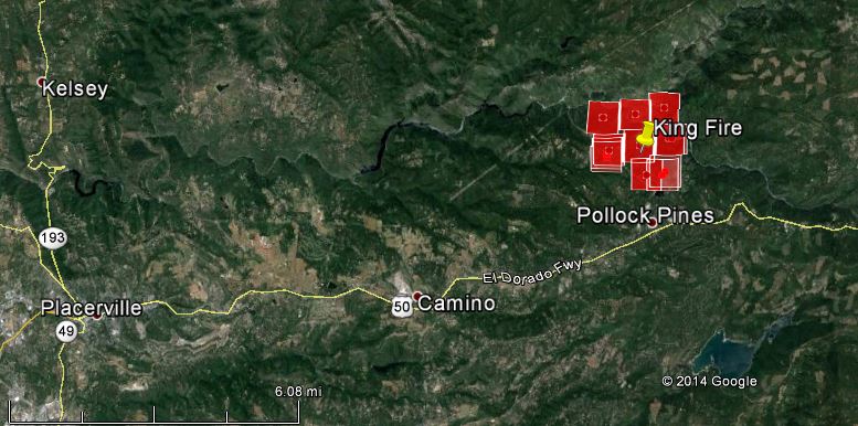
Map of the King Fire at 2:05 p.m. PDT, September 14, 2014. The red squares represent heat detected by a satellite, accurate to within a mile or so. (click to enlarge)
--
Read my blog at http://eclecticarcania.blogspot.com/
My Facebook: http://www.facebook.com/derkimster
Linkedin profile: http://www.linkedin.com/pub/kim-noyes/9/3a1/2b8
Follow me on Twitter @CalDisasters
__._,_.___
No comments:
Post a Comment