How Does Kilauea Volcano Work?
Republished from Eruptions of Hawaiian Volcanoes - Past, Present, and Future by Robert. Tilling, Christina Heliker, and Donald. SwansonU.S. Geological Survey General Information Product 117.
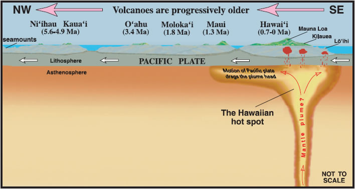
The "Plumbing System" Below KilaueaFrom decades of monitoring and research at HVO, Kïlauea's volcanic "plumbing system" is now relatively well understood. This system links the processes involved in the formation, transport, storage, and, ultimately, eruption of magma to sustain Hawai'i's active volcanoes.Partial Melting Over the Hawaiian Hot SpotKïlauea's plumbing system is believed to extend deep beneath the Earth's surface, where magma is generated by partial melting of material beneath the Pacific Plate as it passes over the Hawaiian hot spot. This belief is based on the persistent recurrence of earthquakes 30 miles or more beneath Hawai'i.Earthquakes occurring 20–30 miles beneath the surface are probably related to the accumulation and upward movement of magma. Seismic data for levels shallower than 20 miles can be interpreted to define diffuse zones of continuous magma rise, one leading to Kïlauea and another to Mauna Loa. Kilauea's Subsurface Magma ReservoirBefore Kïlauea erupts, most of the magma entering the volcano is stored temporarily within a shallow reservoir. Earthquake data and ground-deformation patterns suggest that this reservoir is located 1 to 4 miles beneath the summit and consists of pockets of magma concentrated within a crudely spherical space about 3 miles across. Earthquakes do not occur within the reservoir, because liquid magma does not rupture to generate seismic waves.Summit and Rift Zone EruptionsKïlauea eruptions occur either at its summit or within two well-defined swaths (called rift zones) that radiate from the summit. During summit eruptions, the magma reservoir deflates only slightly, if at all. This relation implies that the rate at which magma is erupted nearly equals that at which the reservoir is refilled by new magma from depth. During an eruption in a rift zone, called a rift or flank eruption, however, the summit region undergoes a significant and abrupt deflation as magma moves quickly from the summit reservoir into the rift zone.Similar summit deflation occurs during a rift intrusion, in which magma injected into the rift zone remains stored underground there rather than breaking the ground surface in an eruption. When the rift eruption or rift intrusion ends, the summit region reinflates as the shallow reservoir is refilled by magma from depth. Small pockets of summit-fed magma may be s tored for a while within a rift zone and form transient secondary reservoirs. The Mauna Loa Plumbling SystemThe volcanic plumbing system for Mauna Loa is less well known. Analysis of data from the well-monitored 1975 and 1984 eruptions, however, suggests that the essential features of Mauna Loa's plumbing system are similar to Kïlauea's, despite the difference in size between the two volcanoes. Mauna Loa's magma reservoir also may be larger than Kïlauea's, which would be consistent with the observations that Mauna Loa eruptions tend to be characterized by higher lava-output rates, longer eruptive fissures, and larger lava flows.Source | 
|
--
Got Penguins?
Penguin News Today
The Science of Penguins
The Gentoos are back! Come see them on live cam at:
Gentoo Penguins of Gars O'Higgins Station, Antarctica

__._,_.___
No comments:
Post a Comment