ka.txt
Keep-Alive Message
This is a Keep-Alive message to continue this Yahoo! Groups email list through slow messaging periods.
000.
------------------------------------
------------------------------------
[ Volcano ]
------------------------------------
Yahoo Groups Links
<*> To visit your group on the web, go to:
http://groups.yahoo.com/group/Volcano/
<*> Your email settings:
Individual Email | Traditional
<*> To change settings online go to:
http://groups.yahoo.com/group/Volcano/join
(Yahoo! ID required)
<*> To change settings via email:
Volcano-digest@yahoogroups.com
Volcano-fullfeatured@yahoogroups.com
<*> To unsubscribe from this group, send an email to:
Volcano-unsubscribe@yahoogroups.com
<*> Your use of Yahoo Groups is subject to:
https://info.yahoo.com/legal/us/yahoo/utos/terms/
Sunday, December 31, 2017
[californiadisasters] File - Abbreviations & Meanings
Here is a list of internet abreviations and their meanings which will help you to better understand what others are saying and will give you some abreviated options for commonly used expressions and terms.
AAR At any rate
AAR can also mean "After Action Report", used in emergency management fields
AAS Alive and smiling
ADN Any day now
AEAP As early as possible
AFAIK As far as I know
AFK Away from keyboard
AISB As it should be
AOTA All of the above
ASAP As soon as possible
AWOL Absent Without Leave
B4 Before
B4N Bye for now
BAK Back at keyboard
BAU Business as usual
BBIAF Be back in a few
BBIAM Be back in a minute
BBL Be back later
BC Because or variously, Battalion Chief
BCNU Be seein' you
BFN Bye for now
BOL Best of luck
BRB Be right back
BTA But then again
BTW By the way
CHAOS Chief Has Arrived On Scene
CMIIW Correct me if I'm wrong
CMON Come one
CT CalTrans (California Department of Transportation)
CU See you
CUA See you around
CUL See you later
CUL8R See you later
CWYL Chat with you later
CYO See you online
DC Division Chief
DEGT Don't even go there
DIKU Do I know you?
DQMOT Don't quote me on this
DTS Don't think so
EM Emergency Management
EMA E-mail address
EOM End of message
F2F Face to face
FISH First in, still here
FAMCL Falling of my chair laughing
FC Fire Captain
FD Fire Department
FITB Fill in the blank
FM Fire Marshall
FUBAR Fudged Up Beyond All Recognition
FWIW For what it's worth
FYI For your information
GA Go ahead
GAL Get a life
GB Goodbye
GFI Go for it
GG Gotta Go
GIAR Give it a rest
GMTA Great minds think alike
GOL Giggling out loud
GR&D Grinning, running and ducking
GTRM Going to read mail
HAGN Have a good night
HAGO Have a good one
HHIS Head hanging in shame
HRU How are you?
HTH Hope this helps
IAC In any case
IAP Incident Action Plan
IB I'm back
IC I see, or variously Incident Command
ICP Incident Command Post
ICBW It could be worse
ICS Incident Command System
ICT Incident Command Team (CALFIRE term)
IDK I don't know
IDTS I don't think so
IIRC If I remember correctly
ILU I love you
ILY I love you
IM Instant message
IMHO In my humble opinion
IMNSHO In my not so humble opinion
IMO In my opinion
IMT Incident Management Team (USFS term)
INAL I'm not a lawyer
IOW In other words
IRMC I rest my case
ITA I totally agree
IUSS If you say so
IYKWIM If you know what I mean
IYO In your opinion
IYSS If you say so
JAC Just a sec
JIK Just in case
JJA Just joking around
JK Just kidding
KOTC Kiss on the cheek
KNIM Know what I mean?
L8R Later
LD Later, dude
LE Law Enforcement
LEO Law Enforcement Officer
LMAO Laughing my a** off
LOL Laughing out loud
LTM Laugh to myself
LTNS Long time no see
MorF Male or female?
MUSM Miss you so much
NBD No big deal
NIMBY Not in my back yard
NMH Not much here
NOYB None of your business
NN Night-Night
NP No problem
NRN No response necessary
NW No way
OIC Oh, I see
OEM Office Of Emergency Management
OES Office of Emergency Services
OMG Oh my God
OO Over and out
OOTD One of these days
OTOH On the other hand
OTTOMH Off the top of my head
PD Police Department
PDQ Pretty darn quick
PLMK Please let me know
PIMP Peeing in my pants
PMFI Pardon me for interrupting
PMFJI Pardon me for jumping in
POAHF Put on a happy face
PTL Praise the Lord
PXT Please explain that
PU That stinks!
RL Real life
RME Rolling my eyes
ROTFL Rolling on the floor laughing
RSN Real soon now
SMHID Scratching my head in disbelief
SNAFU Situation Normal ~ All Fudged Up
SO Sheriff's Office
SOMY Sick of me yet?
SOS Same Old Shtuff
SOTMG Short of time, must go
SPST Same place, same time
SSDD Same stuff, different day
ST or S/T Strike Team
STW Search the Web
SUITM See you in the morning
SUL See you later
SUP What's up?
SYL See you later
TAFN That's all for now
TAM Tomorrow a.m.
TC Take care
THX Thanks
TIA Thanks in advance
TLK2UL8R Talk to you later
TMI Too much information
TMWFI Take my word for it
TPM Tomorrow p.m.
TPTB The powers that be
TSDMF Tears streaming down my face
TTFN Ta ta for now
TTTT These things take time
TTYL Talk to you later
TTYS Talk to you soon
TU Thank you
TY Thank you
TYT Take your time
TYVM Thank you very much
UGTBK You've got to be kidding
UW You're welcome
WAM Wait a minute
WAYF Where are you from?
WB Welcome back
WIIFM What's in it for me?
WTC World Trade Center
WTG Way to go
WTH What the heck?
WTSHTF When the s*** hits the fan
WU? What's up?
WUF? Where are you from?
WWJD What would Jesus do?
WWYC Write when you can
WYSIWYG What you see is what you get
YBS You'll be sorry
YGBKM You gotta be kidding me
YW You're welcome
------------------------------------
------------------------------------
Be sure to check out our Links Section at http://groups.yahoo.com/group/californiadisasters/links
Please join our Discussion Group at http://groups.yahoo.com/group/californiadisasters_discussion/ for topical but extended discussions started here or for less topical but nonetheless relevant messages.
------------------------------------
Yahoo Groups Links
<*> To visit your group on the web, go to:
http://groups.yahoo.com/group/californiadisasters/
<*> Your email settings:
Individual Email | Traditional
<*> To change settings online go to:
http://groups.yahoo.com/group/californiadisasters/join
(Yahoo! ID required)
<*> To change settings via email:
californiadisasters-digest@yahoogroups.com
californiadisasters-fullfeatured@yahoogroups.com
<*> To unsubscribe from this group, send an email to:
californiadisasters-unsubscribe@yahoogroups.com
<*> Your use of Yahoo Groups is subject to:
https://info.yahoo.com/legal/us/yahoo/utos/terms/
[californiadisasters] File - Too Many Messages?
This group frequently has a HIGH MESSAGE VOLUME during major incidents.
If you feel you are getting too many messages, you can change your settings to receive less mail. Instead of receiving Individual Email, you can choose one of the following options:
Daily Digest:
This is the option to choose if you want to see all messages but limit the amount of email you receive. Yahoo will compile up to 25 group messages and send it in a single email to your inbox.
How to do this:
Go to <http://groups.yahoo.com/group/californiadisasters/join>
Under "Step 2. Message Delivery", select "Daily Digest". Scroll down and hit "Save Changes".
Special Notices:
You will not receive group emails except infrequent, important notices from the group moderators. You can still check the group messages on the group home page if you like but will not get them sent to your inbox.
Go to <http://groups.yahoo.com/group/californiadisasters/join>
Under "Step 2. Message Delivery", select "Special Notices". Scroll down and hit "Save Changes".
NOTE: Please do NOT select "Web Only"-- we want to be able to reach you via Special Notice when there are important notifications.
If you have any questions, you can contact the moderators by sending an email to <californiadisasters-owner@yahoogroups.com> and we will be happy to assist you.
Thanks!
The Moderating Team
------------------------------------
------------------------------------
Be sure to check out our Links Section at http://groups.yahoo.com/group/californiadisasters/links
Please join our Discussion Group at http://groups.yahoo.com/group/californiadisasters_discussion/ for topical but extended discussions started here or for less topical but nonetheless relevant messages.
------------------------------------
Yahoo Groups Links
<*> To visit your group on the web, go to:
http://groups.yahoo.com/group/californiadisasters/
<*> Your email settings:
Individual Email | Traditional
<*> To change settings online go to:
http://groups.yahoo.com/group/californiadisasters/join
(Yahoo! ID required)
<*> To change settings via email:
californiadisasters-digest@yahoogroups.com
californiadisasters-fullfeatured@yahoogroups.com
<*> To unsubscribe from this group, send an email to:
californiadisasters-unsubscribe@yahoogroups.com
<*> Your use of Yahoo Groups is subject to:
https://info.yahoo.com/legal/us/yahoo/utos/terms/
[californiadisasters] File - California Disasters DISCUSSION GROUP
Extended discussion threads, chit-chat with other group members or slightly off-topic messages should be posted to the California Disasters DISCUSSION group, which can be found here:
http://groups.yahoo.com/group/californiadisasters_discussion/
All members are urged to join this sister-group and use it to post messages that are not relevant to the purpose of the main list.
Thank you,
Moderator
------------------------------------
------------------------------------
Be sure to check out our Links Section at http://groups.yahoo.com/group/californiadisasters/links
Please join our Discussion Group at http://groups.yahoo.com/group/californiadisasters_discussion/ for topical but extended discussions started here or for less topical but nonetheless relevant messages.
------------------------------------
Yahoo Groups Links
<*> To visit your group on the web, go to:
http://groups.yahoo.com/group/californiadisasters/
<*> Your email settings:
Individual Email | Traditional
<*> To change settings online go to:
http://groups.yahoo.com/group/californiadisasters/join
(Yahoo! ID required)
<*> To change settings via email:
californiadisasters-digest@yahoogroups.com
californiadisasters-fullfeatured@yahoogroups.com
<*> To unsubscribe from this group, send an email to:
californiadisasters-unsubscribe@yahoogroups.com
<*> Your use of Yahoo Groups is subject to:
https://info.yahoo.com/legal/us/yahoo/utos/terms/
[Geology2] File - Rules
Attention Group!
Rule #1 is Rule #1 on all Yahoo groups: NEVER argue with a list-owner or list-moderator! This group is a benevolent dictatorship, NOT a democracy.
Rule #2 is to FOLLOW THE GOLDEN RULE: act as you wish others to act and treat others as you would like to be treated. Failure to follow the Golden Rule will result in our not following the Golden Rule with whomever breaks said Rule.
Rule #3 is there will be ABSOLUTELY NO spamming, trolling, flaming, whining, agitating, cussing or any other anti-social behavior. Violate this rule at the peril of your group membership!
Rule #4 is this group is a POLITICS-FREE and RELIGION-FREE zone. We'll impeach/excommunicate anybody who transgresses!
Rule #5 is STAY ON-TOPIC. We allow for a little bit of flexibility but don't force us to play the heavy and have to clamp down on this behavior.
Rule #6 is AVOID IDLE ON-LIST CHIT-CHAT. Remember there are hundreds of folks on this list and thus keep your posts focused on matters that might interest/edify the group as a whole.
Rule #7 is TRIM YOUR POSTS of excess lineage. Preferably only include the previous message you are responding to if you are indeed responding to previous post(s).
Rule #8 is bring any concerns or complaints you have about anything directly to the list-owners/list-moderators via an OFF-LIST message and DO NOT EVER take matters into your own hands in our stead!
Rule #9 is IF IN DOUBT ... DON'T! If you feel posting a particular remark or item could be a problem then don't do it at all or not until you ask us FIRST!
Rule #10 is USE EMOTICONS! Doing this will cut down on misunderstandings as email is not the best way for human beings to communicate as much nuanced communication such as facial expressions and voice tone are absent in this medium.
Rule #11 is give proper attribution to other groups if you forward to this group any information or a post from another group in part or in whole. It's the courteous thing to do!
------------------------------------
------------------------------------
------------------------------------
Yahoo Groups Links
<*> To visit your group on the web, go to:
http://groups.yahoo.com/group/geology2/
<*> Your email settings:
Individual Email | Traditional
<*> To change settings online go to:
http://groups.yahoo.com/group/geology2/join
(Yahoo! ID required)
<*> To change settings via email:
geology2-digest@yahoogroups.com
geology2-fullfeatured@yahoogroups.com
<*> To unsubscribe from this group, send an email to:
geology2-unsubscribe@yahoogroups.com
<*> Your use of Yahoo Groups is subject to:
https://info.yahoo.com/legal/us/yahoo/utos/terms/
[californiadisasters] On This Date In California Weather History (December 31)
2014: A very cold and potent low pressure system dropped very low-elevation snow during this night and into 12/31.
Snow levels dropped rapidly overnight down to as low as 1000 feet.
The southern Inland Empire was hardest hit. 10"-18" fell across Palomar Mountain, 6"-9" from Warner Springs to Julian, 2"-4" in Temecula, Wildomar, and Lake Elsinore, and 4"-8" across Highway 74 and Horsethief canyon in the Santa Ana Mountains.
Several road closures resulted, including Highway 74 and Highway 18, and vehicles were stranded.
2014: A rare low elevation snow event took place in the Mojave Desert from the afternoon hours of December 30th into New Year's Day 2015.
Significant and crippling snowfall took place in Mohave County, Arizona where numerous roads closed including Interstate 40.
Over 200 vehicle accidents took place alone here on December 31st with some people injured. Snow fell as low as the Colorado River from Hoover Dam south to Lake Havasu City, Arizona and in most instances accumulated, especially above 500 feet.
This was the first accumulating snowstorm in this area since January 1949.
Records for snow were set at Needles, Laughlin, Bullhead City and Lake Havasu City.
Snow totaled as much as 2" in the Colorado River Valley with 3" to 8" in the Kingman, Arizona area. A foot fell in Arizona in Oatman as well as on Hualapai Mountain..
The southerly track of the storm placed Las Vegas on the northwest edge of the storm with flurries falling over the south end of the valley.
This snow was also unusual in that high winds, gusting up to 35 mph, accompanied the snow resulting in blowing and drifting snow.
The snow also knocked out power resulting in pipes bursting as a result of the lack of heat in buildings.
2013: Fresno ended the driest calendar year on record with only 3.01" (26 percent of the normal of 11.5", or 8.49" below average).
This was the first year on record for Fresno to receive less than 1" of precipitation per month in every month.
Fresno also had the warmest year on record with an average temperature of 66.9° F.
Many other locations throughout the Hanford warning and forecast area received well below average rain and snow for calendar year precipitation.
Bakersfield tied for the 2nd driest December on record; only a trace of precipitation fell during the month.
The Decembers of 1989 and 1930 remain the driest Decembers on record for Bakersfield when no precipitation was measured.
2006: Very heavy rainfall produced extensive flooding in Reno and Sparks, NV.
2004: 29" of snow fell at Tahoe City (west shore Lake Tahoe), with 28" reported at Mammoth Lakes Ranger Station.
2002: A mountain wave generated an 84 mph wind gust at Inyokern, causing a tree to fall over and kill one person.
2001: Quick moving front deposited heavy snow in the Sierra: 19" fell at Mitchell Meadow in 9 hours and 28" fell at Wet Meadows in 11 hours.
1999: A waterspout was observed off the coast of Costa Mesa..
Funnel clouds were reported in Santa Ana and Oceanside.
1990: Low of 24° F Fin Fresno.
This was the 24th time all month that the low temperature dropped to 32° F or lower, a record for the month of December.
This also tied January 1949 for the most number of freezing low temperatures in any month.
1986: High tide in San Diego was 7.8 feet.
In Eureka the tide was 9.1 feet, thought to be the highest in a century.
Luckily the weather was fine and surf was small.
Minor flooding occurred at coastal low spots on Mission Beach and Ocean Beach and water lapped at the curbs of streets in Balboa Island, Newport Beach.
1965: A warm storm of torrential rains also melted mountain snow from 12.29 to this day.
One report said more than 13" fell in 24 hours at Mt. Baldy.
Nearly 9" did fall in Lake Arrowhead, and 1.5"-3" in the coastal lowlands.
One drowned in Lytle Creek.
Disastrous flooding and debris flows occurred in the Lytle Creek and Scotland communities, Baldy Village, and in Waterman Canyon.
Two boys were rescued from the Santa Ana River in Colton.
Numerous roads were washed out in the high desert and the mountains.
1955: Mount Hamilton (east of San Jose) received 9" of snowfall.
1941: This day ended the wettest year ever recorded in Las Vegas and the only year in which more than 10" of rain fell.
A total of 10.72" of rain was recorded.
1940: Heavy rains that fell a week previous loosened soil along a Del Mar railroad and led to a landslide.
The slide derailed a train and killed three.
1933: A major storm hit Southern California starting on 12.30 and ending on 1.1.1934.
7.36" fell in 24 hours at LA, a 24 hour record for the city.
8.26" fell as a storm total.
Storm totals in the southern slopes of mountains topped 12" (heaviest: 16.29" in Azusa).
45 died all over Southern California in floods.
Walls of water and debris up to ten feet high were noted in some canyon areas.
1931: Yosemite Valley received 2" of snow bringing the total for the month to 54", making it the snowiest December ever on record here.
1918: It was 22° F in Santa Ana, the lowest temperature on record.
This also occurred the next two days on 1.1 and 1.2.1919, and on 1.6.1950.
It was 24° F in Escondido, the lowest temperature on record for December, and the second lowest temperature on record (lowest was 22° F on 1.22.1937).
1913: Reno, NV, recorded 1.74" of precipitation.
1909: A terrible storm dropped 4.23" of rain in San Bernardino on this day and on 1.1.1910.
Lytle Creek and the Santa Ana River flooded at its highest stage in 20 years.
Railroads were severely damaged down to San Jacinto and Hemet area.
Colton was isolated. Damage in San Bernardino was the "worst in history" and homes in the west of the city were flooded.
Highways, water supplies and other utilities were damaged.
A train from LA plunged into the Santa Ana River in Colton.
1900: Only 27 hours of sunshine were observed in Fresno during December 1900.
This is just 9% of the total possible sunshine available for the month, making it not only the least sunniest December ever, but the least sunniest month ever here.
Source: NWS San Francisco/Monterey, Hanford, Reno, Las Vegas, & San Diego
--

__._,_.___
Posted by: Kim Noyes <kimnoyes@gmail.com>
Be sure to check out our Links Section at http://groups.yahoo.com/group/californiadisasters/links
Please join our Discussion Group at http://groups.yahoo.com/group/californiadisasters_discussion/ for topical but extended discussions started here or for less topical but nonetheless relevant messages.
__,_._,___
[californiadisasters] Wildfires will continue to be 'big ticket issue' for SLO County APCD
Wildfires will continue to be 'big ticket issue' for SLO County APCD
By Chris McGuinnessAs SLO County prepares to ring in the New Year, local air pollution officials are looking back at how past wildfires impacted local air quality.
An annual report by the SLO County Air Pollution Control District listed wildfires as one of the main contributors to air quality standard exceedances in 2016. While the data is still being analyzed, APCD officials expect that 2017's wildfires will also have an impact on county air quality.
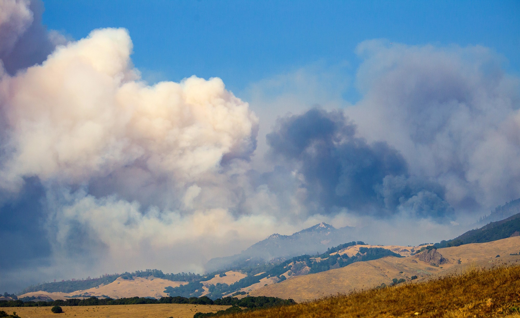
According to the report, smoke from the Soberanes and Chimney wildfires both had "major" impacts on air quality in the county in 2016 and were responsible for many of the instances where the county bypassed federal and state air quality standards. Beginning in July 2016, the Soberanes Fire burned more than 130,000 acres in or near the Los Padres National Forest in Monterey County. It was followed by the Chimney Fire, which raged in August and September 2016, burning more that 46,000 acres around Lake Nacimiento.
"The year's highest ozone concentrations at Paso Robles, Atascadero, Red Hills, and Carrizo Plains ... all occurred during this period," the report stated.
With the embers from the devastating Thomas Fire still smoldering, APCD Officer Gary Willey said the impact of wildfires on air quality would remain a "big ticket" issue for the department, and will likely pop up in its report on 2017.
"We will have a similar narrative," Willey told New Times.
Thus far, the Thomas Fire has burned more than 280,000 acres in Ventura and Santa Barbara counties, making it the largest recorded wildfire the state of California. Despite its massive size, the fire and others that occurred in 2017 might actually have less of an impact on SLO County's air quality than those in 2016.
"My basic instinct is that [2016's] fires impacted us more because of their proximity and the weather conditions," Willey said.
Wildfires will also be a major part of the APCD's mission in 2018. Willey said the department anticipates an increase in the use of controlled burns to mitigate the risk of fires in 2018 and will work with fire officials to strike a balance between the necessity of such burns and their potential impact on local air quality."There's going to be some give and take," Willey said. "This is going to be an issue throughout the entire state."
__._,_.___
Posted by: Kim Noyes <kimnoyes@gmail.com>
Be sure to check out our Links Section at http://groups.yahoo.com/group/californiadisasters/links
Please join our Discussion Group at http://groups.yahoo.com/group/californiadisasters_discussion/ for topical but extended discussions started here or for less topical but nonetheless relevant messages.
__,_._,___