Calderas are some of the most spectacular features on Earth. They are large volcanic craters that form by two different methods: 1) an explosive volcanic eruption; or, 2) collapse of surface rock into an empty magma chamber.
The image at right is a satellite view of one of the most famous calderas - Crater Lake in Oregon. Crater Lake was formed about 7700 years ago when an enormous volcanic eruption of Mount Mazama emptied a large magma chamber below the mountain. The fractured rock above the magma chamber collapsed to produce a massive crater over six miles across. Centuries of rain and snow filled the caldera creating Crater Lake. With a depth of 1932 feet (589 meters), Crater Lake is the deepest lake in the United States and the seventh deepest lake in the world.
Collapse Calderas Collapse calderas form when a large magma chamber is emptied by a volcanic eruption or by subsurface magma movement. The unsupported rock that forms the roof of the magma chamber then collapses to form a large crater. Crater Lake and most other calderas are thought to have formed by this process.
The four-step illustration below explains how the Crater Lake caldera is thought to have formed. The video at right shows a table-top model of caldera formation. This would be an excellent activity for teachers to do with their students or they can simply show the video using computer projection.
| Steps in the formation of Crater Lake Caldera |
 | Eruptions of ash and pumice: The cataclysmic eruption started from a vent on the northeast side of the volcano as a towering column of ash, with pyroclastic flows spreading to the northeast. Caldera collapse: As more magma was erupted, cracks opened up around the summit, which began to collapse. Fountains of pumice and ash surrounded the collapsing summit, and pyroclastic flows raced down all sides of the volcano. Steam explosions: When the dust had settled, the new caldera was 5 miles (8 km) in diameter and 1 mile (1.6 km) deep. Ground water interacted with hot deposits causing explosions of steam and ash. Today: In the first few hundred years after the cataclysmic eruption, renewed eruptions built Wizard Island, Merriam Cone, and the central platform. Water filled the new caldera to form the deepest lake in the United States. Figure modified from diagrams on back of 1988 USGS map "Crater Lake National Park and Vicinity, Oregon." Illustration and caption by the United States Geological Survey. |
Explosive Calderas Explosive calderas are formed when very large magma chambers filled with silica-rich melt and abundant gas move upwards from depth. Silica-rich magmas have a very high viscosity that enables them to hold gas bubbles under very high pressures. As they rise to the surface the reduction of pressure causes the gases to expand and when break-through occurs the result can be an enormous explosion which blasts the caldera. Some of these blasts eject many cubic kilometers of magma and rock.
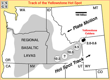
The Yellowstone Supervolcano & Caldera Chain Yellowstone National Park is world-famous for its geysers and hot springs. Those thermal features are easy-to-observe evidence of an active magma system beneath the Park. This magma system has produced some of the largest volcanic eruptions in Earth's history - eruptions so large that they have been called "supervolcanos". One of these eruptions produced a caldera about 50 miles across that underlies most of Yellowstone National Park.
| Yellowstone Caldera Chain |
 | The current caldera at Yellowstone is the most recent in a series of eruptions that span millions of years. The North American Plate is moving west over a stationary hot spot. As the plate moves the hotspot produces an enormous eruption (and a large caldera) every few million years. This has produced regional basaltic lavas and a chain of rhyolitic caldera groups (circles, with ages in millions of years) along the track of the Yellowstone hot spot. |
The Toba Supervolcano About 73,000 years ago the eruption of Toba on the island of Sumatra, Indonesia produced what is believed to be the largest explosive eruption on Earth in at least the past 25 million years.
The Toba blast is believed to have deforested much of central India - about 3000 miles from the eruption site. The blast is thought to have ejected about 800 cubic kilometers of ash into the atmosphere, producing a crater that is 100 kilometers long and 35 kilometers wide. The crater is now the site of the world's largest volcanic lake.
| World's Largest Explosive Eruption |
 | Landsat Geocover image of the caldera formed by the Toba Supervolcano. It is now the world's largest volcanic lake. The image above was produced using Landsat GeoCover data from NASA. |
| Calderas on Other Planets |
 | Complex caldera at the summit of Olympus Mons Volcano - a shield volcano that is the tallest feature on Mars. This caldera is very similar to the caldera complex at the summit of Earth's largest shield volcano - Mauna Loa Volcano on the island of Hawaii. |
| What Causes Explosive Eruptions at Kilauea? |
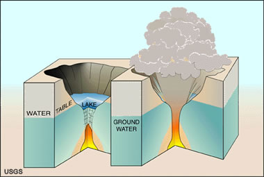
 | Many of Kilauea's pre-1924 explosive eruptions that produced significant ash deposits probably happened when the volcano's summit crater was so deep that its floor was below the water table, letting ground water seep in to form a lake. Whenever magma erupted into the lake water, violent explosions of steam and volcanic gases resulted, fragmenting the magma into tiny ash particles and driving fast-moving, extremely hot ash-laden steam clouds (pyroclastic surges) out of the crater. Image and caption by USGS. |
|  |
 | A satellite view of Crater Lake, one of the world's most famous calderas. Crater Lake formed about 7700 years ago when a massive volcanic eruption of Mount Mazama emptied a large magma chamber below the mountain. The fractured rock above the magma chamber collapsed to produce a massive crater over six miles across. Centuries of rain and snow filled the caldera creating Crater Lake. With a depth of 1932 feet (589 meters), Crater Lake is the deepest lake in the United States and the seventh deepest lake in the world. View a Google Map of Crater Lake. The image above was produced using Landsat GeoCover data from NASA. |
| This video demonstrates a teaching activity that clearly demonstrates how a caldera is formed. It can be difficult to explain or draw how a caldera forms. This table-top model is a great demonstration. Teachers can do this activity with their students or simply show the video in class using computer projection. Venezky Dina, and Wessells, Stephen, 2010, Caldera demonstration model: U.S. Geological Survey Open-File Report 2010-1173. |
| Snow-Covered Calderas - Mona Loa, Hawaii |
 | Snow-covered Moku`aweoweo Caldera atop Mauna Loa shield volcano (Mauna Kea in background). The caldera is 3 x 5 km across, 183 m deep, and is estimated to have collapsed between 600-750 years ago. Several pit craters along the upper southwest rift zone of Mauna Loa (lower right) also formed by collapse of the ground. Image and caption by USGS. |
| Aniakchak Caldera, Alaska |
 | Aniakchak Caldera, located in the Aleutian Range of Alaska, formed during an enormous explosive eruption that expelled more than 50 km3 of magma about 3,450 years ago. The caldera is 10 kilometers in diameter and 500-1,000 meters deep. Subsequent eruptions formed domes, cinder cones, and explosion pits on the caldera floor. |
|


No comments:
Post a Comment