Adore e-mails here JEFF...Keep posting. Tho I have to get though them with my 97 Mom's updates, this what I SIGNED UP for in 2009 after the California fires 2003/2007 NEED updates. I sent off a few to friends here that have second homes there in Northern California.. BTW, they TY so much! Need the Firefighters update. I ask for help. Don't think it is humor, IMHO this is knowledge, awareness and a necessity. Not many seniors know what to do, I am old, but do attempt teach others here TRIM TREES/GET A PACK FOR EMERGENCY etc. I am proud to be here on this site!
Marilyn
Not a problem, humor in these times is always appropriate and appreciated!
On Aug 22, 2020, at 9:34 PM, Thomas Billman <t_billman@hotmail.com> wrote:
just kidding man, the only emails I have gotten in the last 2 days were all you!! lol all 50 emails, but keep them coming!
From: CaliforniaDisasters@groups.io <CaliforniaDisasters@groups.io> on behalf of J Miller <jeffm65@sonic.net>
Sent: Saturday, August 22, 2020 11:29 PM
To: CaliforniaDisasters@groups.io <CaliforniaDisasters@groups.io>
Subject: Re: [CaliforniaDisasters] List of Bay Area Evacuations Due to CZU, LNU, SCU Complex Fires. Updated 38 mins ago
Sent: Saturday, August 22, 2020 11:29 PM
To: CaliforniaDisasters@groups.io <CaliforniaDisasters@groups.io>
Subject: Re: [CaliforniaDisasters] List of Bay Area Evacuations Due to CZU, LNU, SCU Complex Fires. Updated 38 mins ago
will try to Thomas, thanks…
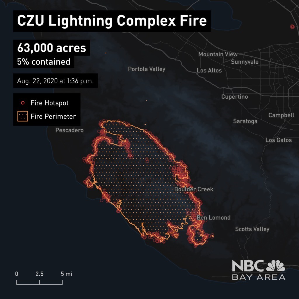 NBC Bay Area
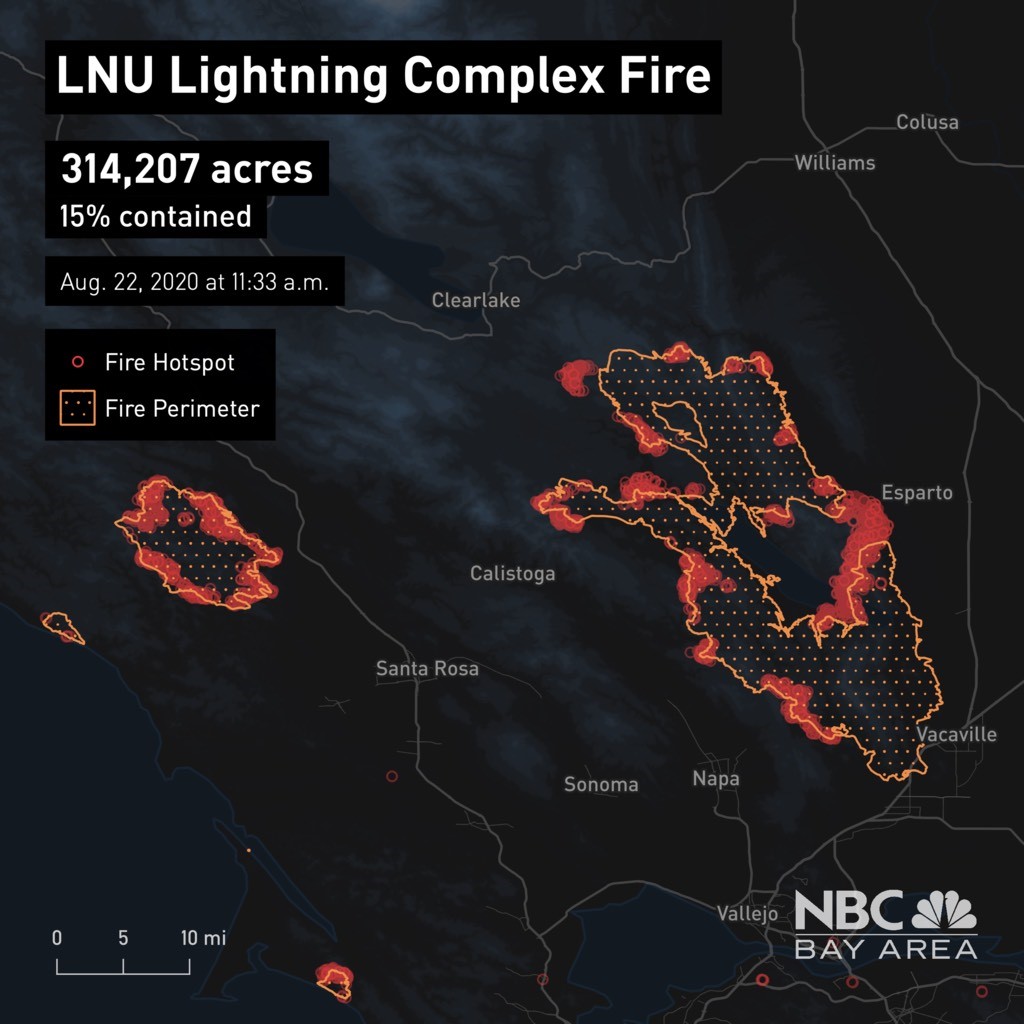 NBC Bay Area
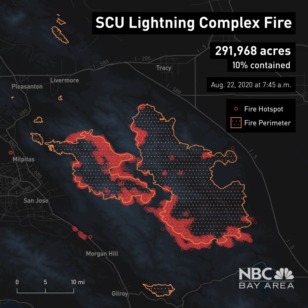 NBC Bay Area
On Aug 22, 2020, at 9:02 PM, Thomas Billman <t_billman@hotmail.com> wrote:
can we limit emails!!! to several topics in 1 email!
From: CaliforniaDisasters@groups.io <CaliforniaDisasters@groups.io> on behalf of J Miller <jeffm65@sonic.net>
Sent: Saturday, August 22, 2020 11:00 PM
To: CaliforniaDisasters@groups.io <CaliforniaDisasters@groups.io>
Subject: [CaliforniaDisasters] List of Bay Area Evacuations Due to CZU, LNU, SCU Complex Fires. Updated 38 mins ago
Sent: Saturday, August 22, 2020 11:00 PM
To: CaliforniaDisasters@groups.io <CaliforniaDisasters@groups.io>
Subject: [CaliforniaDisasters] List of Bay Area Evacuations Due to CZU, LNU, SCU Complex Fires. Updated 38 mins ago
List of Bay Area Evacuations Due to CZU, LNU, SCU Complex Fires
Detailed list of evacuations across the Bay Area, including Marin County, where the Woodward Fire is burning. Surrounding communities are also included.
Dozens of lightning-sparked wildfires have forced tens of thousands of residents to leave their homes. Here's a breakdown of the current evacuation orders and warnings issued by officials.
Most recent alertsEvacuation Warning LNU Lightning Complex Fire - Lake County: East of SR-29, north of Morgan Valley Road, south of SR-20, west of the previous warning evacuation line (Sky High Ridge Road from Morgan Valley Road, extending north to SR-20), excluding the city of Clearlake
Evacuation Order LNU Lightning Complex Fire - Lake County: All residences along and east of Big Canyon Road, Perini Road and Seigler Canyon Road, south of SR-29, west of SR-29 and north of the warning line (Anderson Springs Road, Neft Road and Boggs Mt. Rec Area extending northeast to the intersection of SR-29 and Hofacker Road)
- South of Morgan Valley Road, west of the mandatory evacuation boarder line at Sky High Ridge Road to Highway 29 and Highway 53 in Lower Lake.
- East of Highway 29 at Hofacker Lane to the mandatory evacuation border line.
Evacuation Warning in Anticipation of Weather Event- Alameda County:
- Eastern unincorporated Alameda County:
- East of the Mission Boulevard and Mission Road intersection south to the intersection of Mission Boulevard and Curtner Road
- East of Curtner Road south along I-680 to the Santa Clara County line
- South of I-580 between Greenville Road and the San Joaquin County line to the Alameda and Santa Clara County Line, south of the Livermore city limits (excluding the cities of Livermore and Pleasanton)
- South of Highway 84 between Vineyard Avenue and I-680, south of I-680 to the fire perimeter and the Alameda and Santa Clara County line
- West of the Alameda and San Joaquin County line to the Livermore city limits to Highway 84 to I-680
- North of the fire perimeter and the Alameda and Santa Clara County line to Highway 84 to the Livermore city limits to I-580
CZU Complex: San Mateo, Santa Cruz counties

Santa Cruz County Evacuation Orders
- Waterman Gap Loop, Upper Hwy 236
- Community of Little Basin
- Lowe China Grade
- Upper China Grade, Community of Kings Hwy
- Saratoga Toll Rad
- San Lorenzo Park
- Riverside Grove-Community of Teilh Drive
- Wildwood Road
- Scotts Valley
- University of Santa Cruz campus
- Areas east of Zayante Canyon, west of State Route 17 and south of State Route 35
- Zayante Canyon
- All areas of Felton
- Area of Ben Lomond
- Area of Lompico
- Davenport South to the city limits, including Davenport, Davenport Landing, Coast Road etc.
- Area of Alba Road
- Area of Hubbard Gulch and
- Area of Fanning Grade
- upper San Lorenzo Valley
- Boulder Creek Golf Course
- Waterman Gap Loop
- Heartwood Hill
- Lodge Road
- Community of Kings Highway
- Lower Jamison Creek
- Gallion Heights
- Fallen Leaf Neighborhood
- Foxglove Lane
- Big Basin State Park
- Last Chance Road
- Las Cumbres Road
- Whitehouse Canyon Road
- Everyone on Empire Grade Road
- Felton Empire north
- All of Pine Flat Road
- All of Ice Cream Grade
- Bonny Doon Road, in between Pine Flat Road, Martin Road, and all associated side streets are under an evacuation order.
- Bonny Doon south of Ice Cream Grade, to include Pine Flat Road South
- Areas south of Bear Creek between Hwy. 9 and Hwy. 17 and down to the city limits of Santa Cruz
- Everyone west of Highway 17
- Areas West of Hwy 9 to Empire Grade
- South from Bear Creek Road to Felton, including Ben Lomond
San Mateo County Evacuation Orders
- Bean Hollow Area
- San Gregorio Area
- La Honda Area
- Red Barn Area
- Skylonda Area
- Langley Hill Area
- Pescadero Beach Area
- Butano State Park area, including Barranca Knolls Community
- Butano Creek Drainage
- Loma Mar/Deaborn Park area
- Pescadero Creek County Park area
- Butano Community area
- South Skyline Blvd. area near Hwy 9
- Russian Ridge Open Space Reserve Area
- Middleton Tract Area
- Portola Redwoods State Park
- Portola Heights Community
An evacuation center has been set up at Pescadero High School, which is located at 360 Butano Cutoff in Pescadero.
Another evacuation center has been set up at the Santa Cruz County Fairgrounds at 2601 E Lake Ave. where disaster service workers are on site to assist residents.
Lakeview Middle School in Watsonville is open for shelter with outdoor camping and limited indoor capacity. The address is 2350 E Lake Ave.
LNU Complex: Sonoma, Napa, Solano counties

Sonoma County Evacuations
The following areas of Sonoma County are under evacuation orders:
- East of Dutcher Creek Road and Dry Creek (the actual creek)
- North of Canyon Road
- West of Hwy 101
- South of Canyon Road
- East of Dry Creek (the actual creek)
- North of Lytton Springs Road
- West of Geyserville Avenue
- South of Lytton Springs Road
- North of Westside Road
- West of Healdsburg city limits
- All areas north and east of Westside Rd
- West of Hwy 101
- West of Russian River
- East of Russian River to Windsor Twon limits
- West of Trenton Healdsburg Rd and Eastside Rd
- North of Guerneville Rd
- East of Covey Rd and Hwy 116
- West of Laguna Rd
- South of River Rd
- Residents of Healdsburg West of Hwy 101 off of Chiquita Road. This includes Chateau Real, Matteri Rd, Burgundy Rd, Chablis Rd, Zinfandl Rd and Riesling Rd
- All areas south of River Rd. from Martinelli Rd. to the intersection of River Rd at Trenton Rd.
- West of Covey Rd.
- North of Front St. / Hwy. 116
- East of Martinelli Rd.
- North of Stewarts Point Skaggs Springs Road to the eastern edge of Lake Sonoma
- Everything west of the eastern edge of Lake Sonoma to the western boundary
- that runs north along the ridge line from the intersection of Stewarts Point Skaggs Springs Rd @ Old Stewarts Point Skaggs Springs Road to the interception of Rockpile Road @ Cooley Ranch Road north to the Mendocino County Line All areas south of the Russian River
- East and North of Hwy. 116 (Pocket Canyon)
- West of Martinelli Rd
- Bennett View Drive, Mt. Taylor Drive, Fable Court and Raymonde Way in Santa Rosa
- North of Austin Creek Recreational area
- East of The Cedars
- Mill Creek Road west of the intersection of Puccioni Road
- South of Stewarts Point-Skaggs Springs Road
- West of West Dry Creek Road and Westside Road
- North of Sweetwater Springs Road and McCray Ridge Road
- East of the East Austin Creek (the actual creek)
The following areas of Sonoma County are under evacuation warnings:
- East of Trenton Healdsburd Road
- North of Mark West Station Road
- West of Windsor city limits
- North of River Road
- West of Slusser Road
- South of Mark West Station Road
- North of Dry Creek and norther fork of Lak Sonoma County
- West of Dutcher Creek, city of Coverdale city limits and Hwy 128
- South of Mendocino County line
- South and West of Asti Road
- East of Hwy 101
- North of Hwy 128
- East and North of Green Valley Road
- South and West of Hwy 116
- North of Guerneville Road
- East of Covey Road and Hwy 116
- West of Laguna Rd
- South of River Road
- Meyers Fire - Evacuation Zone 1C1
- All areas east of the Sonoma coast to the south fork of the Gualala River. South of Kruse Ranch Road and Howser Bridge Road to Fort Ross Road.
- Walbridge Fire - Evacuation Zone 4B1 (Northern Forestville)
- All areas south of River Road from Martinelli Road to Trenton Road
- West of Covey Road
- North of Front Street/Highway 116
- East of Martinelli Road
- Walbridge Fire - Evacuation Zone 2K2
- All areas south of Highway 101
- East of the Russian River to the Windsor Town limits
- North of where Windsor River Road dead ends extending west to the Russian River
- Meyers Fire - Evacuation Zone 1E3
- All areas south of the Russian River
- West of Bohemian Highway
- North and east of Coleman Valley Road and Willow Creek Road
- Meyers Fire - Evacuation Zone 1E1
- All areas south and west of Willow Creek Road
- North of Coleman Valley Road and Wright Hill Road
- East of the California Coast National Monument (BLM property)
- Meyers Fire - County Evacuation Zone 1F1
- All areas east of Bohemian Highway
- North of Graton Road and Harrison Grade Road
- West of Harrison Grade Road, Green Valley Road and Highway 116
- South of the Russian River
- Meyers Fire - County Evacuation Zone 1F2
- All areas south of the Russian River
- East and north of Highway 116 (Pocket Canyon)
- West of Martinelli Road
- Walbridge Fire - County Evacuation Zone 4A1
- All areas east of the Russian River
- North of River Road
- West of Trenton Healdsburg Road and Eastside Road
- South of the area between the western dead end of Windsor River Road and the Russian River
- West of Meyers Grade Road to the coast
- South of Fort Ross Road
- North of Russian Gulch State Beach
- North of Austin Creek Recreational area
- East of Cedars
- West of Mill Creek Road
- South of Stewarts Point-Skaggs Springs Road
Napa County Evacuations
Evacuation orders are in place for the following areas of Napa County:
- Highway 29 at the Lake County line to Silverado Trail, Silverado Trail to Highway 128, Highway 128 to Chiles Pope Valley Road, Chiles Pope Valley Road to Pope Valley Road, Pope Valley Road to Butts Canyon Road, and Butts Canyon Road to the county line. This includes the communities of Angwin and Deer Park.
- Pope Valley Road - from Aetna Springs Road to Chiles Pope Valley Road
- Aetna Springs Road - from Pope Valley to the dead end
- Butts Canyon Road - from Aetna Springs Road to the Lake County line
- James Creek Road - from Butts Canyon Road to the dead end
- Highway 128 from Lower Chiles Valley Road to Monticello Road
- Highway 128 from Chiles Pope Valley Road to Lower Chiles Valley Road
- Chiles Pope Valley Road from Highway 128 to Lower Chiles Valley Road
- All of Hennessey Ridge Road
- From Moskowite Corner to Wooden Valley Road, including the community of Circle Oaks
- Atlas Peak from the Bubbling Well Pet Cemetery at 2462 Atlas Peak Rd. to the dead end
- From Loma Vista Road/Soda Canyon Road to the dead end
- All of Steel Canyon Road from Highway 128 to an including the Berryessa Highlands Sub Division
- Wragg Canyon Road from Highway 128 to the end of the road, including Pleasure Cove Resort
- Chiles Pope Valley Road from Lower Chiles Valley Road to Pope Canyon Road
Evacuation warnings are in place for the following areas of Napa County:
- West of Hwy. 29 on top of Oakville Grade for Niebaum Lane, Manley Lane, Beerstecher Road and Bella Oaks Lane
- Monticello Road from Vichy Avenue to Silverado Trail
- Ink Grade - from Pope Valley Road to White Cottage Road
- Howell Mountain Road - from Pope Valley Road to White Cottage Road
Evacuation orders were lifted for the following areas:
- Hwy 121 (Monticello Road) from Vichy Ave to Silverado Trail
An evacuation center has been established at Crosswalk Community Church, which is located at 2590 First St. in Napa. An animal evacuation center is located at the Napa County Animal Shelter at 942 Hartle Court in Napa.
Solano County Evacuations
Evacuation orders are in effect for the following areas of Solano County:
- Paradise Valley neighborhood
- Rolling Hills neighborhood
- Rancho Solano and Sanctuary neighborhoods
- Evacuation notification for residents in northeast Vacaville that includes the following streets: Browns Valley Road from Shelton Lane South to Brown Street on the west side, Vine Street and Vine Street estates, Gibson Canyon Road, Fruitvale Road to N. Orchard Avene
- Shelton Lane and North and West Browns Valley Road in Vacaville; North of Gates Canyon Road to Quail Canyon Road; all of Pleasants Valley Road and connecting streets/roads; all of the English Hills area of Vacaville; and all of the Solar Hills and Gibson Canyon Road areas
- Areas of Rockville Road, Suisun Valley Road, Gordon Valley Road, Wooden Valley Road, Clayton Road and Mankas Corner in Fairfield
Lake County Evacuations
Evacuation orders are in effect for the following areas of Lake County:
- All residences along and east of Big Canyon Road, Perini Road and Seigler Canyon Road, south of SR-29, west of SR-29 and north of the warning line (Anderson Springs Road, Neft Road and Boggs Mt. Rec Area extending northeast to the intersection of SR-29 and Hofacker Road)
- South of Morgan Valley Road, west of the mandatory evacuation boarder line at Sky High Ridge Road to Highway 29 and Highway 53 in Lower Lake.
- East of Highway 29 at Hofacker Lane to the mandatory evacuation border line.
- Areas in and around Hidden Valley Lake and Jerusalem Valley, including north of Butts Canyon Road, south of Hofacker Lane to Morgan Valley Road, east of Highway 29 and west of the Lake/Napa County line
Evacuation warnings are in effect for the following areas of Lake County:
- East of SR-29, north of Morgan Valley Road, south of SR-20, west of the previous warning evacuation line (Sky High Ridge Road from Morgan Valley Road, extending north to SR-20), excluding the city of Clearlake
Evacuation Centers
- Lambrecht Fields - Petersen Road, Suisun City
- Rodriguez High School
- Vacaville Ice Rink, 551 Davis Street, Vacaville
- McBride Senior Center, 91 Town Square Place, Vacaville
- Sierra Vista School- 301 Bel Air Drive Vacaville
- Ulatis Community Center, 1000 Ulatis Drive, Vacaville
- Will C. Wood High School, 998 Marshall Road, Vacaville
- Joseph Nelson Community Center, 611 Village Center Drive, Suisun
- Lambrecht Sports Complex, Lambrecht Drive, Suisun
- Old Walmart Parking Lot, 300 Chadbourne Road, Fairfield Guru Nanak Sikh Temple, 2948 Rockville Road, Fairfield
- Vallejo Fairgrounds, 900 Fairgrounds Drive, Vallejo (Large animals allowed)
- In Sonoma County, the Santa Rosa Fairgrounds is being used as an evacuation point where evacuees may find information on where they can go.
RAW: LNU Complex Fire Spreads to Homes in Solano County
Raw video shows flames from the LNU Complex Fire in the North Bay spreading into Solano County and burning homes there.
SCU Complex: Santa Clara, Alameda, Contra Costa, San Joaquin and Stanislaus counties

Alameda/Stanislaus counties
Evacuation orders have been issued in the following areas in Alameda/Stanislaus counties:
- Frank Raines Park to Mines Road
- Del Puerto Canyon Road 1 mile to Mines Road
Evacuation warnings have been issued in the following areas in Alameda County in anticipation of an upcoming weather event:
- Eastern unincorporated Alameda County:
- East of the Mission Boulevard and Mission Road intersection south to the intersection of Mission Boulevard and Curtner Road
- East of Curtner Road south along I-680 to the Santa Clara County line
- South of I-580 between Greenville Road and the San Joaquin County line to the Alameda and Santa Clara County Line, south of the Livermore city limits (excluding the cities of Livermore and Pleasanton)
- South of Highway 84 between Vineyard Avenue and I-680, south of I-680 to the fire perimeter and the Alameda and Santa Clara County line
- West of the Alameda and San Joaquin County line to the Livermore city limits to Highway 84 to I-680
- North of the fire perimeter and the Alameda and Santa Clara County line to Highway 84 to the Livermore city limits to I-580
Santa Clara County
Evacuation orders are in place for the following areas in Santa Clara County:
- East of San Jose City limits
- South of Mt. Hamilton Rd..
- North of Metcalf Rd. & San Felipe Rd., East to the County Line
- East of San Antonio Valley Rd. to Del Puerto Canyon Rd. to the County Line
- South of Stanislaus County Between Santa Clara County Line and I-5
- West of I-5 North of Stanislaus/Merced County Line
- North of Stanislaus/Merced County Line
- East of Santa Clara County Line, East if Ed Levine County Park, Felter Rd., Sierra Rd.,
- Toyon Ave., and Mt. Hamilton Rd. to Three Springs Rd.
- North of Hwy 130 to Santa Clara County Line
- West of San Antonio Valley Rd.
- West of Mines Rd. to Santa Clara County Line
- East of 3 Springs Rd. and Mt. Hamilton Rd.
- South of Santa Clara County Lin
- North of Mt. Hamilton Rd. to Three Springs Rd.
- South of Santa Clara County Line
- West of the Fire Perimeter
- East of Ferguson Rd. East and North of Hwy 152
- West of Merced County Line
- North of Hwy 152
- South of Metcalf Rd at Shingle Valley Rd.
- East to the Stanislaus County line
- East of Shingle Valley Rd. and everything East of Anderson Lake, East of Coyote Creek,
- East of Coyote Reservoir, East of Roop Rd., East of Leavesley Rd., East of Crews Rd.,
- East of Ferguson Road.
- East and North of Hwy 152
- West of Merced County Line, North of Hwy 152
- South of Metcalf Road at Shingle Valley Road, East to the Stanislaus County Line
Evacuation warnings are in place for the following areas in Santa Clara County:
- South of Metcalf Rd. East of Coyote Creek to the Anderson Lake Shore, East of Chochrane Rd., East of Hill Rd. and South of Main Ave., North of Maple Ave., East of Foothill Ave, North of San Martin Ave, East of New Ave..
- West of Shingle Valley Rd.. and everything West of Anderson Lake, West of Coyote Creek, West of Coyote Reservoir, North and West of Roop Rd. between Coyote Reservoir Rd. and New Ave
- East of Lovers Lane and the Santa Clara County
- South of Hwy 152 to the San Benito County line
- West to the Merced County Line
- North of San Benito County Line to Hwy 152
Alameda County
The city of Berkeley is advising residents of the Berkeley Hills to "be ready to evacuate with or without notice" as wildfires spread quickly. More information, here.
Evacuation orders have been issued in the following areas in Alameda County:
- Frank Raines Park to Mines Road
- Del Puerto Canyon Road 1 mile to Mines Road
- All of Mines Road, south of Mile Marker 10 to the county line
Evacuation warnings have been issued in the following areas in Alameda County:
- City of Fremont - Mill Creek Road
San Joaquin County
Evacuation orders have been issued in the following areas in San Joaquin County:
- South of West Corral Hollow Road to Stanislaus County line
- West of I-580 to Alameda County line
- East of Alameda County line to I-580 and the Stanislaus County line
Evacuation warnings have been issued in the following areas in San Joaquin County:
- All of PAR Estates which are the following streets: W. Vernalis Road, Bernard Drive, Stearman Road, Brichetto Court, Stearman Court, S Chrisman Road south of I-580, and the Tracy Golf & Country Club
- North of West Corral Hollow Road to I-580
- East of the Alameda County line to I-580
Stanislaus County
Evacuation warnings have been issued in the following areas in Stanislaus County:
- South of Diablo Grande Parkway and the Diablo Community
Evacuation Centers:
- Creekside Middle School at 535 Peregrine Dr. in Patterson
- Milpitas Library at 160 N. Main St. in Milpitas
- Ann Sobrato High School - Performing Arts Building at 401 Burnett Ave. in Morgan Hill
For more information, click here.
Woodward Fire: Marin County
Marin County
Evacuation warnings are in place for the following areas in Marin County:
- West of Highway 1 and Sir Francis Drake Blvd (northern intersection) to the Point Reyes Lighthouse. This includes the communities of Olema, Inverness, Inverness Park and Sea Haven.
- Sir Francis Drake to the Bay Area Ridge Trail, continuing to the Bolinas Ridge Fire Road and the McCurdy Trail – all areas west of those intersections
- Point Reyes National Seashore west of Highway 1 is now closed to all visitors
- Coastal sections of West Marin - residents living and visiting west of Shoreline Highway (State Route 1) between Sir Francis Drake Boulevard in Olema south to Bolinas, a stretch of about 11.5 miles
_._,_._,_
Groups.io Links:
You receive all messages sent to this group.
View/Reply Online (#34133) | Reply To Group | Reply To Sender | Mute This Topic | New Topic
Your Subscription | Contact Group Owner | Unsubscribe [paws_sassy@yahoo.com]
_._,_._,_
__._,_.___

No comments:
Post a Comment