Salt Domes
Columns of low-density salt that rise through overlying rock units
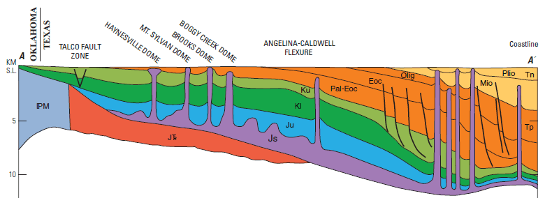
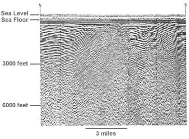
| This cross-section shows rocks of the East Texas Basin between the Oklahoma-Texas border (on the left) and the Gulf of Mexico coastline (on the right). The purple rock unit is the Middle Jurassic salt, a low-density rock that has the ability to flow slowly under pressure. The salt is overlain by higher density rock units, making it buoyant. The salt has erupted up through the overlying rocks like streams of high-viscosity oil moving up through a layer of water above. The salt columns and smaller mounds are called "salt domes." USGS image [1]. |
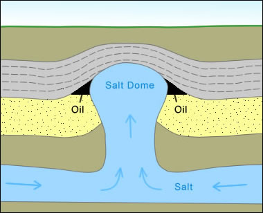
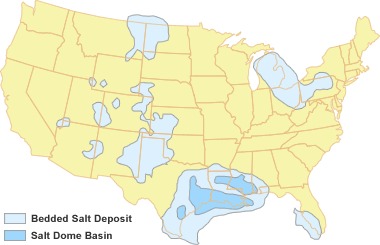
What is a Salt Dome?A salt dome is a mound or column of salt that has risen toward the surface because it has a density that is lower than the rock above it. The salt behaves like a stream of high-viscosity oil ascending in slow motion through a thick layer of water above.In the illustration above, the purple rock unit (Js) was originally a layer of salt. Now you can see several columns of salt penetrating the overlying rock units in their rise to the surface, and several small mounds that might develop into columns over time. Why Do Salt Domes Form?Rock salt (the mineral halite) has two properties that enable it to form salt domes: 1) when salt is buried to depths greater than a few thousand feet, it will have a density that is much lower than most other sedimentary rocks; and, 2) salt has the ability to deform and flow like a high-viscosity fluid when it is under pressure.When a layer of salt is deposited on the floor of an evaporating body of water, it has a specific gravity of about 2.2. Other sedimentary rocks such as shale and limestone have lower specific gravities when they are deposited because the mud that they form from contains a significant amount of water. As the depth of burial increases, the specific gravity of salt remains about the same, but the specific gravity of shale and limestone increases as the water is squeezed from their pore spaces. Eventually they might have a specific gravity of 2.4 to 2.7, which is significantly higher than the salt. That creates an unstable situation where a lower specific gravity material that is capable of behaving like a fluid is overlain by materials with a higher specific gravity. Salt movement can be triggered if the rock sequence is subjected to tectonic forces. Compression will produce folding, and salt domes might erupt through the crests of anticlines. Extension will produce thinning and normal faulting, which might create weaknesses that the salt will exploit. Shear can produce faults or weaknesses that might be exploited by the unstable salt. How Large Are Salt Domes?Salt domes can be very large structures. The salt cores range from ½ mile to 5 miles across. The parent rock units that serve as a source of salt are usually several hundred to a few thousand feet thick. The salt domes ascend from depths of between 500 and 6000 feet (or more) below the surface [2]. They usually do not reach the surface. If they do a salt glacier might form.The First Salt Dome Oil DiscoverySalt domes were almost unknown until an exploratory oil well was drilled on Spindletop Hill near Beaumont, Texas in 1900 and completed in 1901. Spindletop was a low hill with a relief of about 15 feet where a visitor could find sulfur springs and natural gas seeps.At a depth of about 1000 feet, the well penetrated a pressurized oil reservoir that blew the drilling tools out of the well and showered the surrounding land with crude oil until the well could be brought under control. The initial production from the well was over 100,000 barrels of crude oil per day - a greater yield than any previous well had ever produced. The Spindletop discovery ignited a drilling spree on similar structures across the Gulf Coast area. Some of these wells struck oil. Those discoveries motivated geologists to learn about the structures below that held such vast amounts of oil [3]. Careful subsurface mapping of well data, and later the use of seismic surveys, enabled geologists to discover the shape of salt domes, develop hypotheses about how they form, and understand their role in petroleum exploration. Economic Importance of Salt DomesSalt domes serve as oil and natural gas reservoirs, sources of sulfur, sources of salt, underground storage sites for oil and natural gas, and disposal sites for hazardous waste.OIL AND NATURAL GAS RESERVOIRS Salt domes are very important to the petroleum industry. As a salt dome grows, the cap rock above it is arched upwards. This cap rock can serve as an oil or natural gas reservoir. As a dome grows the rocks that it penetrates are arched upwards along the sides of the dome (see both illustrations at the top of this page). This upward arch allows oil and natural gas to migrate toward the salt dome where it can accumulate in a structural trap. The rising salt can also cause faulting. Sometimes these faults allow a permeable rock unit to be sealed against an impermeable rock unit. This structure can also serve as an oil and gas reservoir. A single salt dome can have many associated reservoirs at a variety of depths and locations around the dome. A SOURCE OF SULFUR Salt domes are sometimes overlain by a cap rock that contains significant amounts of elemental sulfur. The sulfur occurs as a crystalline material filling fractures, intergranular pores, and in some cases replacing the cap rock. The sulfur is thought to have formed from anhydrite and gypsum associated with the salt by bacterial activity. Some salt domes have enough sulfur in the cap rock that it can be economically recovered. It is recovered by drilling a well into the sulfur and pumping superheated water and air down the well. The superheated water is hot enough to melt the sulfur. The hot air converts the molten sulfur into a froth that is buoyant enough to rise up a well to the surface. Today most sulfur is produced as a byproduct from crude oil refining and natural gas processing. The production of sulfur from salt domes is generally not cost competitive with sulfur produced from oil and natural gas. SALT PRODUCTION Some salt domes have been exploited by underground mining. These mines produce salt that is used as a raw material by the chemical industry and as salt for treating snow-covered highways. A few salt domes have been mined by solution. Hot water is pumped down a well into the salt. The water dissolves the salt and is brought back to the surface through production wells. At the surface the water is evaporated to recover the salt, or the salty water is used in a chemical process. UNDERGROUND STORAGE RESERVOIRS Some of the mines developed in salt domes have been carefully sealed and then used as storage sites for oil, natural gas, and hydrogen. Salt domes in the United States and Russia also serve as national repositories for government reserves of helium gas. Salt is the only type of rock that has a permeability so low that it can hold the tiny helium atoms. WASTE DISPOSAL Salt is an impermeable rock that has the ability to flow and seal fractures that might develop within it. For this reason salt domes have been used as disposal sites for hazardous waste. Man-made caverns in salt domes have been used as repositories for oil field drilling waste and other types of hazardous waste in the United States and other countries. They have also been considered for high-level nuclear waste disposal, but no site in the United States has received that type of waste. Where Do Salt Domes Occur?Salt domes can occur in sedimentary basins where thick salt deposits have been buried by at least 500 feet of other types of sediment. One of the world's largest salt dome regions is the Gulf of Mexico. Over 500 salt domes have been discovered onshore and under the Gulf of Mexico seafloor. They originate from the Louann Salt, a subsurface rock unit that is laterally persistent throughout the area. A map in the right column of this page shows the location of bedded salt deposits in the United States and three salt dome fields. Large fields of salt domes have also been discovered in Angola, Brazil, Canada, Gabon, Germany, Iran and Iraq.Contributor: Hobart King
http://geology.com/stories/13/salt-domes/
| 
|
--

__._,_.___
No comments:
Post a Comment