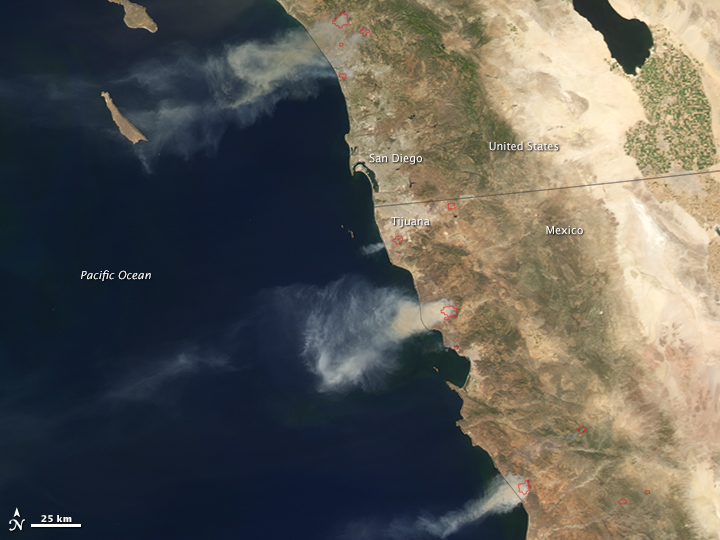
The 2014 wildfire season got off to a ferocious start in southern California and northwestern Mexico when record-breaking temperatures and powerful Santa Ana winds fueled at least nine fires between May 14–16. Cal Fire estimated that by the morning of May 16, more than 19,000 acres (7,700 hectares) had burned, and news reports said that more than 100,000 people were forced to evacuate at various points over the past few days.
The Moderate Resolution Imaging Spectroradiometer (MODIS) on NASA's Aqua satellite detected several fires in San Diego County on May 14, 2014. MODIS also observed large fires burning in the Baja California region of Mexico. Red outlines indicate hot spots where the sensor detected unusually warm surface temperatures associated with fires. Winds blew thick plumes of smoke west over the Pacific Ocean.
According to Cal Fire, the Pulgas fire had charred 8,000 acres and was just 5 percent contained by the morning of May 16. The Cocos/San Marcos Fire had burned 3,018 acres and was 10 percent contained. The Tomahawk fire, which includes part of the U.S. Marines Camp Pendleton, had burned 6,300 acres and was 23 percent contained. More than 1,500 acres were consumed by the Bernardo fire, which was 90 percent contained. At the time of published, Earth Observatory could not find ground-based information on the fires in Mexico.
Drought has plagued the western United States—especially central and southern California—for months, priming vegetation for wildfires. By mid-May, the entire state was classified as being in some level of drought (ranging from severe to exceptional), according to the U.S. Drought Monitor. To break the drought, most of the state would need 9 to 15 inches (23 to 38 centimeters) of precipitation to fall in one month, Weather Underground meteorologist Jeff Masters estimated. That would amount to more than a half-year's worth of precipitation for most of the state.
Aqua MODIS captured a second image of the California fires on May 15.
References
- Cal Fire (2014, May 16) Current Fire Information. Accessed May 16, 2014.
- CNN (2014, May 16) 'Unprecedented' wildfires, fierce winds lead to 'firenadoes' in California. Accessed May 16, 2014.
- The Washington Post's Capital Weather Gang (2014, May 15) Drought, heat, wind spark destructive wildfires in Southern California. Accessed May 16, 2014.
- ESRI (2014, May 16) US Wildfire Activity Public Information Map. Accessed May 16, 2014.
- Jeff Masters WunderBlog, via Weather Underground (2014, May 15) Record May Heat, Drought, and Fires Scorch California. Accessed May 16, 2014.
- The Los Angeles Times (2014, May 16) Wildfires. Accessed May 15, 2014.
- Mashable (2014, May 16) Wildfires Scar the Drought-Ridden Landscape of Southern California. Accessed May 16, 2014.
- Reuters (2014, May 15) Firefighters battle raging San Diego wildfires. Accessed May 16, 2014.
- The Los Angeles Times (2014, May 15) Wildfires. Accessed May 15, 2014.
- The Washington Post Capital Weather Gang (2014, May 15) Drought, heat, wind spark destructive wildfires in Southern California. Accessed May 15, 2014.
NASA Earth Observatory image by Jesse Allen, using data from the Land Atmosphere Near real-time Capability for EOS (LANCE). Caption by Adam Voiland and Mike Carlowicz.
- Instrument(s):
- Aqua - MODIS
--
Read my blog at http://eclecticarcania.blogspot.com/
My Facebook: http://www.facebook.com/derkimster
Linkedin profile: http://www.linkedin.com/pub/kim-noyes/9/3a1/2b8
Follow me on Twitter @CalDisasters
__._,_.___
No comments:
Post a Comment