VOLCANO WATCH: Unraveling Hawaiian Volcano Histories
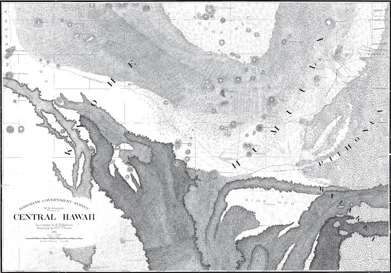 This 1891 map shows much of the saddle between Mauna Kea (at top of map) and Mauna Loa. Lava flows depicted as black irregular shapes in the lower half of the map were erupted from Mauna Loa, with labeled ages ranging from "ancient" to 1881. The Mauna Kea branch of the 1880–1881 lava flow, visible as a small, thumb-shaped flow at the bottom center of the map, sits atop the much larger 1855–1856 lava flow that also threatened Hilo. To see details of this extraordinary map, go to http://ags.hawaii.gov/survey/map-search/,enter "1718" in the "Registered Map No." box, and click "Search" to open the full resolution map. Map courtesy of Hawai'i State Archives.
by Hawaiian Volcano Observatory
USGS Hawaiian Volcano Observatory scientists extract as much insight as possible from historic accounts of eruptions, and then combine that information with current observations of activity to improve our understanding of how Hawaiian volcanoes work. Recent Volcano Watch articles have compared past records for topics such as the Halema'uma'u lava lakes over time, the Mauna Loa lava flow that threatened Hilo in 1881, and the Kilauea lava flow that threatened Pāhoa in 2014-2015.
Further detective work on the Mauna Loa eruption that started on Nov. 5, 1880, reveals that witnesses saw three separate lava flows advance from the volcano's Northeast Rift Zone in the first few days of the eruption. The first flow (the Mauna Kea branch) advanced north into the Saddle area and stalled a few days later. The second flow (the Ka'ū branch) moved toward Kilauea caldera and also stalled several days later. The third and last lava flow from this eruption (the Hilo branch) advanced toward the northeast and, by summer of 1881, threatened Hilo (this flow was the subject of our March 2015 Volcano Watch.)
Until recently, all three branches of the 1880–1881 lava flows were represented on geologic maps of the Island of Hawai'i. But an ongoing remapping effort for Mauna Loa has produced some surprises—one of which is that the flow mapped as the first and northernmost 1880 lava (the Mauna Kea branch) was actually erupted a few years later—in 1899.
The true identity of this flow was determined by matching its chemistry with other lavas that are known with certainty to have been erupted in 1899. It would be hard to challenge such definitive geochemical evidence, but we still don't know what happened to the reported Mauna Kea branch of the 1880–1881 eruption.
Going back to newspapers of the time, one can find clear descriptions of the three flow branches, with the first branch advancing north into the saddle just north of the Mauna Loa 1855 lava flow (right where it was formerly mapped). One of these accounts described a trip by a pair of explorers who traveled from the vent high on the rift zone down into the Saddle along the Mauna Kea branch of the flow.
Of course, GPS didn't exist in the 1880s, so these travelers, at best, might have had a barometer that estimated elevation using variations in air pressure. Some travelers recorded approximate elevations of landmarks that we can recognize today. A few others published sketch maps in the newspaper along with their harrowing accounts of the eruption.
In addition, government surveyors of that era were working hard on mapping the Hawaiian Kingdom using triangulation and chaining distances (literally using a chain of known length and counting how many "chains" it took to replicate the distance). Toward the end of the nineteenth century, many areas were mapped, including the Saddle between Mauna Kea and Mauna Loa. There was a lot of sketching "by eye" that went into mapping the Mauna Loa side of the Saddle, but it was still useful.
Some of these wonderful old maps can be found online at the Hawai'i State Archives. For this particular quest, registered map number 1718 (from the year 1891) shows the first branch of the 1880–1881 lava flows (a dark, thumb-shaped lobe peeking up from the bottom of the map) lying on 1855–1856 lava.
These maps confirm that there was a Mauna Kea branch of the 1880–1881 eruption, but that, in fact, it may have only been about 13 km (8 mi) long instead of 20 km (12 mi) long, as the map showed it until recently.
With further mapping, the Mauna Kea branch may have been found again—under the later 1899 flows or to the side of the 1855–1856 flow. The challenge now is to see whether we can identify the Mauna Kea branch in remaining kipuka within the 1899 flow or nearby areas.
Boots-on-the-ground field work is still the best way to ascertain the geologic record of a volcano. However, geologic questions can sometimes be answered by good old archival research, so we are fortunate that so many archives are now available online.
Kilauea Activity Update
Kilauea's summit lava lake level fluctuated over the past week with changes in summit inflation and deflation, but remained well below the rim of the Overlook crater vent. During the past week, the lake ranged between 40 and 55 m (130–180 ft) below the current floor of Halemaʻumaʻu.
Kilauea's East Rift Zone lava flow continues to feed widespread breakouts northeast of Puʻu ʻŌʻō. Active flows are slowly overplating and widening the flow field, and remain within about 8 km (5 mi) of Puʻu ʻŌʻō.
No felt earthquakes were reported on the Island of Hawaiʻi in the past week.
Volcano Watch is a weekly article and activity update written by scientists at the U.S. Geological Survey`s Hawaiian Volcano Observatory.
--

__._,_.___
No comments:
Post a Comment