Stunning Photos of Alaska's Erupting Veniaminof Volcano

 |
 Photo of Veniaminof volcano taken by plane on Aug. 18, 2013, in the Aleutian Range in Southwest Alaska. This image shows a steam cloud from lava melting snow and ice and an ash cloud billowing from the summit. Photo of Veniaminof volcano taken by plane on Aug. 18, 2013, in the Aleutian Range in Southwest Alaska. This image shows a steam cloud from lava melting snow and ice and an ash cloud billowing from the summit.Credit: Game McGimsey, AVO/USGS |
A recent helicopter ride over an active volcano resulted in spectacular images of steam, lava and ash billowing from Alaska's Veniaminof volcano. The 8,225-foot-tall (2,507 meters) volcano has erupted on-and-off since June 13, melting snow and ice and strewing ash and volcanic debris across the summit.
On Aug. 18, geologists from the Alaska Volcano Observatory (AVO) and Dickinson College in Pennsylvania flew over the summit to survey the ongoing eruption. Photos taken during the flight show a cone built above the active volcanic vent inside Veniaminof's caldera, a giant crater formed during a massive eruption about 3,700 years ago. Steam rises from the foot of the cone, where streaming lava melts snow and ice. Ash rises in bursts from the vent, according to the AVO's Veniaminof report. The cone is about 1,080 feet (330 m) tall, the AVO said.

 Aerial view of the erupting intracaldera cone at Veniaminof, Aug. 18, 2013. This photo shows new lava flows produced since the eruption started on June 13. These flows, roughly 3000 feet (900 meters) long, have descended the southwest flank of the cone and traveled onto the ash-covered snow and icefield. Melting of the snow and ice has created the depressions beneath the young flows.
 Credit: Game McGimsey, AVO/USGS
Dickinson College volcano expert Ben Edwards measured lava flow temperatures at Veniaminof during the helicopter flight. Edwards studies the interactions between lava and ice, and is tracking how fast the lava melts ice at the summit. He also plans to collects lava samples from near the volcanic cone.
Read more: Alaska Volcano Observatory
http://www.livescience.com/39120-veniaminof-volcano-stunning-photos.html
~~~~~~~~~~~~~~~~~~~~~~~~~~~~~~~~~~~~~~~~~~~~~~~~~~~~~~~~~~~~~~~~~~
Friday, August 23, 2013,
Dangerous Glacier Peak volcano minimally monitored
Mount Rainier, by contrast, has nine stations. Mount Hood has five. Mount Baker has two. Newberry volcano in Oregon has nine stations, Crater Lake three.
Because of federal budget cuts due to the sequestration, it likely will be a while longer before scientists are able to add enough stations to fully monitor Glacier Peak, officials say.
Plans were in the works to place five more monitors on or close to the volcano as early as the end of this summer.
Now, that will have to wait at least another year, said John Ewert, scientist-in-charge at the U.S. Geological Survey's Cascades Volcano Observatory in Vancouver, Wash.
"Right now, Glacier Peak is a volcano that we consider to be a very high threat volcano," he said. "It is at the present time the least well-monitored of all the Cascade volcanoes."
Glacier Peak is 10,541 feet high and located southeast of Darrington in the Cascade Mountains, just inside the far eastern edge of Snohomish County. Because it's tucked behind other mountains, it's not as visible or as well-known as other nearby peaks.
Glacier Peak has had some huge eruptions in its history, sending walls of mud, rocks, trees and melted glacier water roaring down the Stillaguamish and Skagit valleys, obliterating everything in their path. Darrington is built on the remnants of several of these lahars, as the flows are called.
Glacier Peak also has exploded fairly frequently compared to other Cascade volcanoes, Ewert said.
The peak last erupted about 240 years ago, just before the Revolutionary War, and its last major eruption was about 1,800 years ago. Several are believed to have occurred before then.
That history makes it the second most explosive mountain in the Cascade Range in terms of both the power and frequency of its eruptions, Ewert said.
The seismic sensors come in different shapes and sizes, with one type consisting of about a 3-by-3 foot box with a pole and antenna sticking up to send the data.
The monitors detect small movements within the mountain -- little tremors that could add up to something big.
It was this type of information that alerted officials, and in turn the public, to the eventual eruption of Mount St. Helens in 1980, Ewert said.
The better the monitoring, the earlier the potential warning before an explosion, he said.
Also, work on completing a geological map of Glacier Peak, detailing its eruptive history, is being delayed as well, officials said.
"I cancelled my Glacier Peak fieldwork last summer and only lately decided there were sufficient funds for a short visit in September this year," said Tom Sisson, scientist in charge at the USGS volcano center in Menlo Park, Calif., who is compiling the historical data.
Ewert had to cut $225,000 from his budget this year off last year's total -- between 30 and 40 percent, he said.
Scientists have to get into the wilderness to scout potential sites for the monitoring stations. Researchers are now doing this work near Glacier Peak and expect to have some of these spots identified by the end of this summer, Ewert said.
Even to do this much, "we kind of scraped our change up from other projects that had to be done."
Once the sites are chosen, the stations must go through an environmental permitting process. Though the stations are small, the time and energy spent gathering data for these permits can cost $10,000 apiece, according to Ewert.
It was hoped that work could be done this year, but it had to be put off at least until next summer, he said.
"That may not happen, it may have to be pushed to 2015 or '16. It makes it a more drawn out process."
Other mountains got in line ahead of Glacier Peak for new monitoring equipment recently. This was either because they were near major cities, such as Mount Hood and Mount Rainier, or were more easily accessible for researchers, such as Newberry Volcano in Oregon, Ewert said. Mount Rainier was another undermonitored volcano, he said.
"Our science budgets haven't budged in a number of years and we've had a number of things we've had to respond to," Ewert said. "We've knocked off some of the low-hanging fruit."
Glacier Peak is remote and USGS researchers have to hike in and camp. "We've got a two-month window every year when Glacier Peak is workable," Ewert said.
Another casualty of the sequestration is a laser-mapping system called lidar, that provides scientists with more detailed information about terrain. "It is expensive, and I basically had to take that off the table this year completely," he saidl.
Cutting lidar accounted for about $100,000 of the reduction for his budget this year, Ewart said.
Much of the other expense for scientists is travel, particularly if they fly, he said.
Attendance at conferences was included in the cutbacks. Critics have said this isn't such a bad thing.
"There is no question that federal employees should have some travel and go to some conferences, but most of it has nothing to do with their jobs," U.S. Sen. Tom Coburn, R-Okla., told the New York Times. "It's a perk."
Ewart disagrees, saying that important exchanges of information take place at such meetings.
A plan is in place for communication between agencies and with the public in the event of an eruption, called the Mount Baker/Glacier Peak Coordination Plan.
Some warnings and protections are in place, said John Pennington, director of the Department of Emergency Management for Snohomish County.
"We could always use more data but I do believe we have enough indicators at least for emergency management in Snohomish County to sufficiently receive warning of volcanic activity in and around the Cascade Range," he said.
~~~~~~~~~~~~~~~~~~~~~~~~~~~~~~~~~~~~~~~~~~~~~~~~~~~~~~~~~~~~~~~~~~~~~~~
Indonesia's submarine Mount Hobalt volcano rumbles to life in brief eruption
Fri, 23 Aug 2013

"Many people, including fishermen, saw the peak of [Mount Hobalt] surface for a few minutes," Peter said on Tuesday. He said that a similar phenomenon took place when the volcano last erupted in May 1999. Tini Thadeus, the head of the NTT Disaster Mitigation Agency, said that the volcano briefly belched a column of smoke and ash that reached between 1,000 and 2,000 meters above sea level at around 7:13 a.m. on Tuesday. Meanwhile, Victor Mado Watun, the island's deputy district chief, said that another volcano, Mount Ile Wereng, which straddles the inland subdistricts of Atadei and Wulandoni, also experienced a brief eruption. Victor said that a three-kilometer radius danger zone around the two mountains has been declared. "The district's disaster mitigation office has sent two teams to the Atadei and Wulandoni. They are monitoring the activity of two volcanoes there and are registering the number of villagers living near them," Victor said. Hobalt is one of the five active submarine volcanoes in Indonesia, a country that sits on three geological fault lines dotted with volcanoes. - Jakarta Times
http://www.sott.net/article/265313-Indonesias-submarine-Mount-Hobalt-volcano-rumbles-to-life-in-brief-eruption
~~~~~~~~~~~~~~~~~~~~~~~~~~~~~~~~~~~~~~~~~~~~~~~~~~~~~~~~~~~~~~~~~~~~~~~~~
Santiaguito volcano (Guatemala): partial dome collapse generates strong explosion and pyroclastic flows
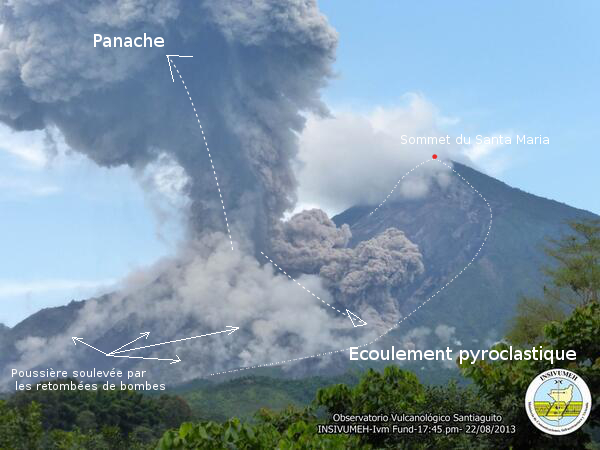
August 23, 2013 – GUATEMALA – A major eruption occurred yesterday evening. Starting at 17:45 (local time), the top part of the Caliente lava dome collapsed and produced a series of relatively large pyroclastic flows and explosions. Ash plumes rose more than 2 km to elevations of 4 km altitude. The cause of the eruption was likely the accumulation of pressurized magma and gas under the dome composed of viscous (solid) lava. The pyroclastic flows affected mainly the south, southeast and NNE sides. Bombs from explosive activity were ejected to distances of 500 m. –Volcano Discovery
Kamchatka: Activity has remained elevated. A series of ash emissions caused by moderately strong vulcanian-type explosions occurred over the past days. This morning, an ash plume rose to 8,000 ft (2.4 km) altitude and drifted east. Meanwhile, Shiveluch: The volcano continues to extrude a new lobe of viscous lava (visible as the dark patch in the webcam image) at the lava dome, as well as produce occasional (usually small) ash explosions –Volcano Discovery
http://theextinctionprotocol.wordpress.com/2013/08/23/santiaguito-volcano-guatemala-partial-dome-collapse-generates-strong-explosion-and-pyroclastic-flows/~~~~~~~~~~~~~~~~~~~~~~~~~~~~~~~~~~~~~~~~~~~~~~~~~~~~~~~~~~~~~~
Two UW volcano studies shed light on future risks

by GLENN FARLEY / KING 5 News
Posted on August 22, 2013
SEATTLE -- Two new studies involving the University of Washington are shedding new light on the internal workings and risks from volcanoes, especially the ones in the Cascade range in Washington, Oregon and Northern California.
In one, just published in the journal Geology, lead author, UW volcanologist and graduate student Sarah Gelman finds through computer modeling that molten pools of magma can sit in a molten or semi-molten state below volcanoes for longer than previously thought. And the longer that rock remains in a molten state, the higher the silica concentration can go.
What's silica? You know it as the main ingredient in commonplace things like beach sand and glass. But in its molten form in magma silica tends to make volcanic eruptions more explosive. In rocks from the Mount St. Helens eruption in 1980, the silica content is as high as 65 percent. The 1980 eruption was explosive -- it blew the top 1,500 feet off the mountain and killed 60 people.
Conversely, the silica content in Hawaiian volcano eruptions is much lower, around 50 percent. The rest of the content being various metals like iron and aluminum. Hawaiian eruptions tend to consist of lava flows and do not explode like Cascade volcanoes do.
Mount St. Helens is one of the most studied volcanoes in the world. In a second study called IMUSH, which stands for Imaging Magma Under St. Helens, scientists from the University of Washington, Oregon State and other institutions plan a massive test to find out just how big the magma chamber is under the mountain.
"Mount St. Helens is kind of the pilot volcano for studies of this kind," said Alicia Hotovec-Ellis, a UW volcano seismologist and grad student taking part in the study.
That study gets underway with field work next summer, with the placement of more than 2,500 seismometers on St. Helens that will pick up seismic waves triggered by small explosions around the mountain over several days. The study will also include longer-term monitoring of the reflection of natural earthquake waves off the magma reservoir below. Hotovec-Ellis says the plan is to model the shape of the system that's feeding Mount St. Helens all the way down to Earth's hot mantle.
Both projects will continue to lay the foundation for more research to come. One of the drivers of these studies is to learn enable so scientists will better be able to predict when eruptions could happen and how big they could be.
"The Holy Grail would be to predict an eruption and get people out so it causes no loss of life," said Gelman.
--

__._,_.___
No comments:
Post a Comment