Bicentenary of the first national geological map
It's good to know that the geosciences have had revolutionising developments to match those of the rest of science. Forget the Battle of Waterloo in 1815, which of course was 'the nearest-run thing you ever saw in your life' when the Brits were saved from defeat by the timely arrival of the Prussians: This year we can celebrate one that literally put geology on the map, kicked-off the systematic exploration for every kind of physical resource, thereby putting a great deal of money in the pockets of coal, petroleum and metal moguls and making geology a career rather than a pastime. In 1815 William Smith published A Delineation of the Strata of England and Wales with part of Scotland, which despite the title was a map showing the basic geology and structure of the whole of England and Wales: the first ever map showing accurately the distribution of rocks for an entire country. The original, at 2.6 by 1.8 m, dominates the main staircase at Burlington House, the home of the Geological Society of London.
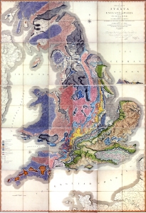
William Smith's A Delineation of the Strata of England and Wales with part of Scotland (1815)
Tom Sharpe has nicely summarized the key facts surrounding Smith's masterpiece (Sharpe, T. 2015. The birth of the geological map. Science, v. 347, p. 230-232). One feature that I certainly did not know was that the colour scheme for the different stratigraphic units was based on the dominant colour of the rocks themselves, such as purples for the abundant slates of the Lower Palaeozoic, brown and red for the Old- and New Red Sandstone, greys and blacks for the Coal Measures and green for the Greensand, which until quite recently remained widely used to signify Cambrian, Ordovician and Silurian; Devonian and Permian; Upper Carboniferous and Cretaceous.
Although celebrated today, Smith's map was panned by the gentlemen geologists of the Geol Soc, who attempted to do a better job, but failed ignominiously. William Smith was not a leisured chap of the Enlightenment, but worked for a living surveying coal mines, navigating canals and draining fens. Despite their antipathy, the Fellows of the Geological Society of London knew a good earner when they saw one and plagiarized Smith's work and undercut his regular price for his map. As a result he ended up in a London debtors' prison. Even on the day of his release in 1819, bailiffs seized his house and its contents. The Geol Soc eventually did honour Smith with its Wollaston Medal in 1831, its then president Adam Sedgwick dubbing him 'the Father of English Geology': by that time geology had become a profession…
--

__._,_.___
No comments:
Post a Comment