Seismic concerns mount at Anderson Dam south of San Jose
By David Jacobson, Temblor

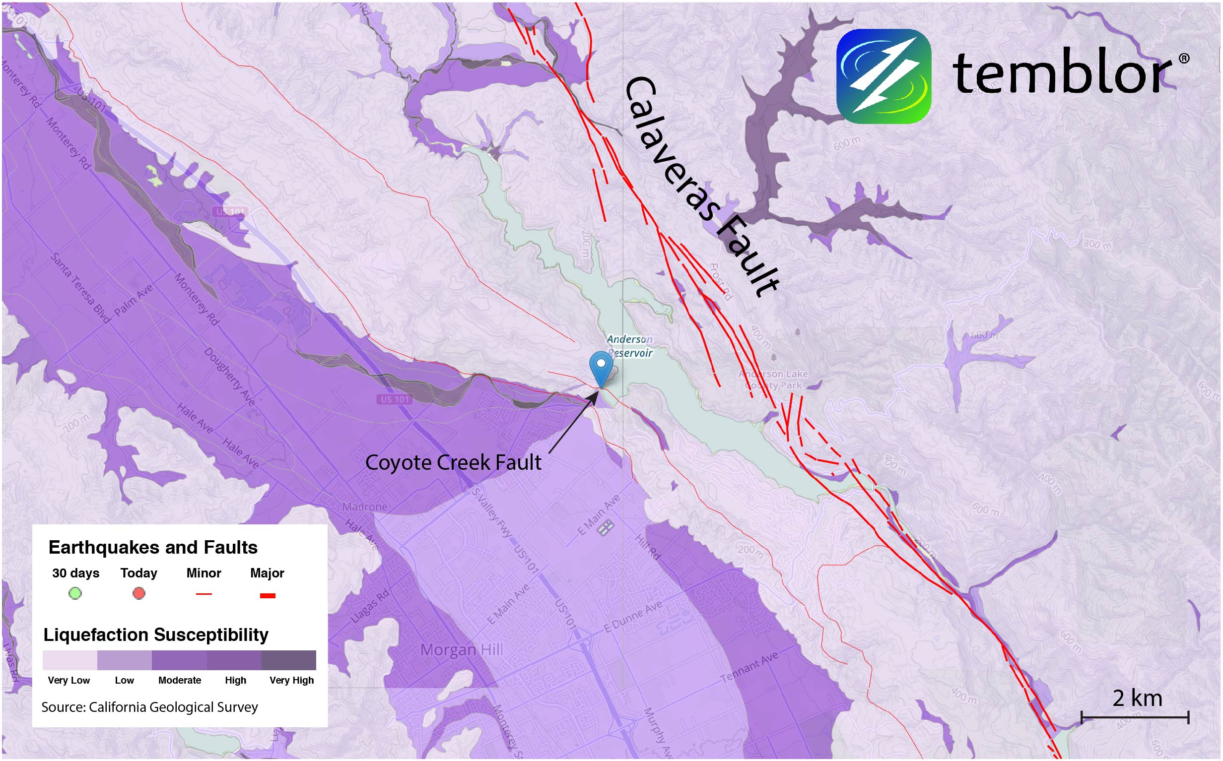
While the Oroville Dam has been at the center of headlines for the last week, there is a dam in Santa Clara County, just south of San Jose, which is also concerning officials. Anderson Dam is the largest dam in Santa Clara County, and Anderson Lake provides drinking water and a recreational area for residents. However, it also sits right next to the Calaveras Fault, which, according to the USGS, has a 26% chance of rupturing in a large earthquake by 2043. Additionally, the Coyote Creek Fault runs right underneath the dam.

Because of this high hazard, the reservoir behind the dam is not permitted to be more than 68% full. This hazard is consistent with Temblor's Hazard Rank of 96. However, due to heavy rainfall in the Bay Area in the last several weeks, as of yesterday (February 15) the dam was 99.3% full. It should be pointed out that while water will likely flow over the spillway due to upcoming storms, the same failure which prompted the evacuation of people near the Oroville Dam is not likely at Anderson Dam, according to the Santa Clara Valley Water District. Nonetheless, some flooding is still possible.

Due to the high hazard at Anderson Dam, officials have been working on a plan to retrofit the dam since 2009. The process began after a 2007 seismic stability evaluation found that embankments both upstream and downstream of the dam could become unstable in a large earthquake. However, while the Anderson Dam Seismic Retrofit Project (ADSRP) officially began in 2012, the earliest construction will begin is 2020, at a cost of approximately $400 million (Up from the originally projected $200 million).
In order to understand what exactly could happen at Anderson Dam, we looked at the 2011 Seismic Stability Evaluation Report done by AMEC Geomatrix, Inc., for the Santa Clara Valley Water District. This report, which at the time of its completion, used updated ground motions, material properties, and procedures, highlighted several dam weaknesses. AMEC Geomatrix determined that due to highly liquefiable soils, following an earthquake, the downstream embankment will likely become unstable, possibly leading to "an uncontrolled release of reservoir water." Additionally, the upstream embankment could undergo 11-25 feet of permanent deformation, which could also lead to an uncontrolled release of water.

This combination of weaknesses led AMEC Geomatrix to say that, "the estimated permanent deformations, both upstream and downstream, are considered unacceptable for dam safety." They recommended that the District attempt to mitigate the effects of a large earthquake as soon as practical.
Based on a December 2016 Anderson Dam Seismic Retrofit Project Update by the Santa Clara Valley Water District, it is clear that addressing these liquefiable soils is the chief objective. Not only will the embankments both upstream and downstream be retrofitted, but the plan is to remove all liquefiable material surrounding the dam. Assuming construction begins in 2020, it is estimated it will be completed by 2024.

It should be pointed out that it is not a guarantee that in the event of a large earthquake, the dam will fail. The 1989 Loma Prieta earthquake, which caused very strong shaking at the dam's location, according to the USGS ShakeMap, did not result in failure. Nonetheless, based on the report by AMEC Geomatrix, the dam's estimated performance is worrying. Therefore, hopefully the retrofit goes as planned.
References
AMEC Geomatrix, Inc. Report (Justin D. Phalen, Faiz I. Makdisi, and Marc J. Ryan, Anderson Dam Seismic Stability Evaluation Report (SSE-1A), June 2011, 313 pages) Link
December 2016 Anderson Dam Seismic Retrofit Project Update (Presented by the Santa Clara Valley Water District) Link to website
Bay Area Regional Climate Change Preparedness Report, Attachment 2, Project Justification, Association of Bay Area Governments, Proposition 84, Integrated Regional Water Management, 2015 Implementation Grant Application. Link
California Department of Water Resources
USGS
California Geological Survey
Keith Knudsen et al (2000), Preliminary maps of Quaternary deposits and liquefaction susceptibility, nine-county San Francisco Bay region, California: a digital database, U.S. Geological Survey Open-File Report
NBC Bay Area
http://temblor.net/earthquake-insights/seismic-stability-concerns-at-anderson-dam-2554/?utm
--
__._,_.___
No comments:
Post a Comment