Wednesday, December 31, 2014

Re: [californiadisasters] Rose Bowl Whirlwind


It doesn't take much to take out those shade structures.  Still, that's impressive & too bad some people got hurt.

I cleaned up a dozen or so palm fronds from my yard this morning.  I don't have any palm trees!

Kate

On Wed, Dec 31, 2014 at 3:47 PM, Kim Noyes kimnoyes@gmail.com [californiadisasters] <californiadisasters@yahoogroups.com> wrote:


Eclectic Arcania regrets not being there to experience it:

http://eclecticarcania.blogspot.com/2014/12/rose-bowl-whirlwind.html


__._,_.___

Posted by: Kate Hutton <katehutton@gmail.com>


Be sure to check out our Links Section at http://groups.yahoo.com/group/californiadisasters/links
Please join our Discussion Group at http://groups.yahoo.com/group/californiadisasters_discussion/ for topical but extended discussions started here or for less topical but nonetheless relevant messages.


__,_._,___

[Geology2] New Paper: Aniakchak Volcano, Alaska Peninsula


Postglacial Eruptive History, Geochemistry, and Recent Seismicity of Aniakchak Volcano, Alaska Peninsula

By Charles R. Bacon, Christina A. Neal, Thomas P. Miller, Robert G. McGimsey, and Christopher J. Nye

http://pubs.usgs.gov/pp/1810/


--


__._,_.___

Posted by: Lin Kerns <linkerns@gmail.com>


__,_._,___

[californiadisasters] Rose Bowl Whirlwind


Eclectic Arcania regrets not being there to experience it:

http://eclecticarcania.blogspot.com/2014/12/rose-bowl-whirlwind.html


__._,_.___

Posted by: Kim Noyes <kimnoyes@gmail.com>


Be sure to check out our Links Section at http://groups.yahoo.com/group/californiadisasters/links
Please join our Discussion Group at http://groups.yahoo.com/group/californiadisasters_discussion/ for topical but extended discussions started here or for less topical but nonetheless relevant messages.


__,_._,___

[californiadisasters] Breaking News: 4 injured at Rose Bowl after freak wind event


Breaking news | ABC7 Los Angeles

Wednesday, December 31, 2014


Four people were injured in a freak wind event at the Rose Bowl in Pasadena that destroyed tents and sent people scrambling to get away.

A wind advisory is in effect for the San Fernando Valley, Santa Clarita Valley, San Gabriel Valley and Ventura County coastal valleys until 9 a.m. Thursday.

Get more details


FACEBOOK Like ABC7TWITTER Follow @abc7


Advertisement


__._,_.___

Posted by: Kim Noyes <kimnoyes@gmail.com>


Be sure to check out our Links Section at http://groups.yahoo.com/group/californiadisasters/links
Please join our Discussion Group at http://groups.yahoo.com/group/californiadisasters_discussion/ for topical but extended discussions started here or for less topical but nonetheless relevant messages.


__,_._,___

[Geology2] Plate Tectonics, Subducting Slabs, and Nature Papers


Plate Tectonics, Subducting Slabs, and Nature Papers

December 28, 2014 / gemmabenevento

I've mentioned before in this blog that the Earth is made up of continental and oceanic plates.  At convergent plate margins, less buoyant oceanic plates are subducted beneath the continental plates, and drawn down into the mantle.  Although the mantle is often depicted as convecting molten lava, it is actually solid rock.  The reason that the solid rock in the mantle is able to convect however, is due to the immense stress that it is subjected to over huge periods of geological time.

The way a slab behaves once it begins its descent into the mantle is poorly understood.  The only evidence we have of the shape of these subducted slabs at depth is from seismic imaging1, where the colder, more rigid slab is visible amid the hot, convecting mantle.  These images, however, are often difficult to interpret.  Moreover, they only offer us a snapshot in time, while tectonic processes span unimaginably long geologic timescales.  For this reason scientists often disagree on the angle of trajectory for the descending oceanic plate.

A Case Study

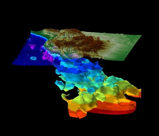
Image 1: Slab wall imaged underneath North America (Credit: Sigloch; http://www.geophysik.uni-muenchen.de/Members/sigloch (see also ref. 2)).

As North America moved westward after the initial breakup of Pangea2 ~200 million years ago, the Panthalassa Ocean to its west began to close.  For many years, geologists believed that the Farallon plate that lay beneath the Panthalassa Ocean, was subducted eastwards into a trench at the western edge of North America.  In an exciting new paper, however, geologists Dr Karin Sigloch and Dr Mitchell Mihalynuk have proposed a new theory for the history of the slab that lies beneath North America.  After analysing high resolution topographic images of the slab (see image 1), they found that its horizontal cross-sectional shape did not match the contours of the western coast of North America.  Moreover, the slab is a massive 400-600km across, 4-6 times thicker than would be expected from a single sheet of subducting lithosphere3 .  The plate appears to have been subducted at a close to vertical angle, and so there became a need to explain its unexpected thickness.  The vertical appearance of the subducted plate further contradicted a westward-moving trench along the west coast of North America.  There also appears to be a second phase of subduction, a younger (shallower) section of slab wall which lays further west, and connects up to present day subduction under North America.

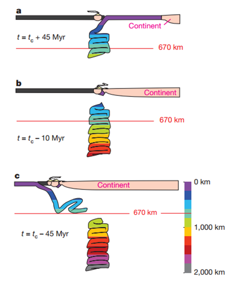
One way in which the geologists were able to explain these phenomena was by the presence of a volcanic arc system within the Panthalassa Ocean (the ocean that existed to the west of North America at this time).  If there had been a string of island arcs, the Farallon slab could have subducted to the west, into a stationary trench along the archipelago (see image 2).  This would explain the discontinuity between the shape of the subducted slab wall and the shape of the west coast of North America.  Once the Panthalassa Ocean that lay to the east of the archipelago-associated trench had closed, North America would have collided with the island arcs, and a 'polarity switch' would have occurred.  Now, the remaining ocean that lay to the west of the arcs would be subducted to the east, underneath North America.

Image 2: (a) Westward subduction and slab pile-up under volcanic arc, (b) collision of North America with the volcanic arc, and closure of the ocean that lay east of the arc system, (c) polarity-shift in subduction, and subduction of the remaining ocean in an easterly direction (Credit: Reference 1).

Image 2: (a) Westward subduction and slab pile-up under volcanic arc, (b) collision of North America with the volcanic arc, and closure of the ocean that lay east of the arc system, (c) polarity-shift in subduction, and subduction of the remaining ocean in an easterly direction (Credit: Reference 1).

An explanation for the huge width of the slab was also proposed in this paper, and has far-reaching implications for future studies of slab dynamics.  As already discussed above, the mantle flows.  At approximately 670 km, there is a viscosity4 jump within the mantle, where the mantle below is much more viscous than above.  The theory here is that the subducting slab moves relatively easily through the less viscous upper mantle, but begins to buckle and fold onto itself as it reaches this boundary.  There may even be a period of time where the slab is not dense enough to continue its descent into the lower mantle, and would therefore have to 'wait' at the boundary until there is enough material to allow the slab to pass through into this higher viscosity environment.

Please follow this link *doi:10.1038/nature12019* to read more about this exciting new theory!

1Seismic imaging distinguishes between the cold rigid slab and the hot convecting mantle by the speed at which the P-waves travel through it.  P-waves are able to travel faster through colder, denser material.

2Pangea was a supercontinent that formed ~300 million years ago during the Late Palaeozoic, and existed for just over 100 million years, before it began to break up during the Mesozoic.

3Lithosphere comprises the Earth's crust, and some of the uppermost mantle.

4Viscosity is the extent to which a substance resists uniform flow.  For example, honey is more viscous than water.

Bibliography

  1. Sigloch, K., & Mihalynuk, M.G., Intra-oceanic subduction shaped the assembly of Cordilleran North America. Nature. 496. 50-57 (2013) (doi:10.1038/nature12019).
  2. Sigloch, K., McQuarrie, N., & Nolet, G. Two-stage subduction history under North America inferred from multiple-frequency tomography, Nature Geoscience, 1, 458 – 462 (2008) (doi:10.1038/ngeo231).
https://gemmabenevento.wordpress.com/2014/12/28/plate-tectonics-subducting-slabs-and-nature-papers/
--


__._,_.___

Posted by: Lin Kerns <linkerns@gmail.com>


__,_._,___

[Geology2] (Wow) 2014-12-30 night time-lapse video of Fuego volcano, Guatemala


__._,_.___

Posted by: Lin Kerns <linkerns@gmail.com>


__,_._,___

Tuesday, December 30, 2014

[Geology2] Cloud of ash belched out by Kamchatka volcano spreading 35 km eastwards


Cloud of ash belched out by Kamchatka volcano spreading 35 km eastwards

Russia
December 30, 8:38 UTC+3
The aviation authorities have assigned the orange level of aviation risks to the eruption
© ITAR-TASS/Institute of Volcanology and Seismology of the Far East Department at the Russian Academy of Sciences/Archive

PETROPAVLOVSK-KAMCHATSKY, December 30. /TASS/. A cloud of ash belched out by the Sheveluch volcano in Kamchatka is spreading 35 kilometers eastwards and volcanic particles are drifting with the wind to the Pacific Ocean in bypass of populated localities, spokespeople for the Kamchatka Volcano Eruptions Reaction Team (KVERT) of the Russian Academy of Sciences told TASS on Tuesday.

Gallery
11 photo
© Arnar Thorisson/Helicopter.is/AP/dapd

Four years since Eyjafjallajokull eruption

"The volcano has ejected cinders to the altitude of 6,000 meters above sea level," the source said.

The aviation authorities have assigned the orange level of aviation risks to the eruption, which means that the volcanic particles ejected from the Sheveluch's crater pose a potential menace for all types of aircraft and can put out the engines of airliners and helicopters our of operation.

The Sheveluch, which is 3,283 meters tall, is the northernmost of Kamchatka's volcanoes. The nearest populated locality, the township of Klyuchi, is located 80 kilometers away from it.

The Sheveluch, which is also spelt as Shiveluch or Sopka Shiveluch sometimes is a hyperactive volcano. The recorded disastrous eruptions occurred in 1854 and 1956.

The current eruption started on August 15, 1999, and continues to this day.

Klyuchi is a compact township and its population can be evacuated rapidly enough in case of a major eruption.

http://itar-tass.com/en/russia/769932
--


__._,_.___

Posted by: Lin Kerns <linkerns@gmail.com>


__,_._,___

Re: [Geology2] Residents below aging B.C. dam warned: in case of major earthquake, get out in 10 minutes or die


They seem to want to have their cake and eat it, too. Getting rid of the damn condemns the residents to natural floods which the dam prevents and if the dam is abandoned it is also a hazard.... basically, the subsidized residents want somebody else to pay for fixing what is allowing them to safely live where they live.

On Tue, Dec 30, 2014 at 6:22 AM, Lin Kerns linkerns@gmail.com [geology2] <geology2@yahoogroups.com> wrote:
 

Residents below aging B.C. dam warned: in case of major earthquake, get out in 10 minutes or die


Tristin Hopper | December 29, 2014

A BC Hydro study determined the Jordan River dam had the highest seismic hazard in B.C., and concluded it was not practical to rebuild it.
BC HydroA BC Hydro study determined the Jordan River dam had the highest seismic hazard in B.C., and concluded it was not practical to rebuild it.

VANCOUVER — After deciding it would be too expensive to rebuild a 103-year-old dam built in one of the most collapse-prone areas of Canada, British Columbia's power utility has settled on a controversial plan: Bracing for a disastrous flood.

JordanRiver_C_JR

"[I]n a magnitude 9 earthquake, the people down below would have 10 or 15 minutes to get out of there, or I guess the bottom line is that they would all die," said Mike Hicks, municipal director for the area.

Since early December, BC Hydro has been busily transforming the area surrounding its Jordan River dam into a flood-ready no-man's-land.

The utility is pushing to stop development in the future "inundation zone" and has successfully obtained a ban on overnight camping at a popular nearby park. It is also looking to install a warning siren to alert day-trippers if they are about to be swamped by several million litres of reservoir water.

Most contentious of all, the provincial utility offered to buy up 11 houses and businesses in the tiny community of Jordan River, a once-thriving resource town that would largely be flattened by a dam collapse.

Locals are uniformly outraged at the offer, even as they see the value of their homes being wiped out by the news.

"For just about everybody around here it's not a money thing; we don't want to move, fix your dam," said Doug Harvey, speaking to local television.

Mr. Hicks noted camping at Jordan River Regional Park was being shut down only four years after the municipal government spent $9.9-million to buy the land.

"If they're going to ask us to have no overnight camping, they should buy our park, simple as that," he said. "They sterilized Jordan River, and they're the ones responsible for this."

News of the looming dam collapse has also scuttled plans to turn the park over to the nearby Pacheedaht First Nation, who were to build a campground and interpretative centre.

Said Mr. Hicks, "That's all gone, too, with BC Hydro's announcement that they'll all be dead."

While the utility claims it cannot fix the dam, it has acknowledged there are ways the structure could be prevented from collapsing in an earthquake.

'I guess the bottom line is that they would all die'

BC Hydro  could simply lower the water in the reservoir, but it said this would cause an electricity shortfall that could cost as much as $200-million to fix.

The dam could also be decommissioned, but this would also be "highly costly" and would risk flooding homes with spillover from an unregulated Jordan River.

The utility's dramatic plans for the area were fuelled by an alarming seismic study released this month showing the Jordan River dam, built in 1911, sits atop one of the most vulnerable parts of British Columbia and possibly the country.

When the Big One hits (an event that is statistically due for coastal B.C.), the dam will shake as much as three times harder than buildings in Downtown Vancouver.

The pressures are virtually guaranteed to rip apart the structure and kick off what has clinically been called an "uncontrolled release of upstream reservoir water." As the utility said in a statement, it was "not aware of any dams in the world" strong enough to straddle the Jordan River without collapsing.


-- http://news.nationalpost.com/2014/12/29/residents-below-aging-b-c-dam-warned-in-case-of-major-earthquake-get-out-in-10-minutes-or-die/


--


__._,_.___

Posted by: Kim Noyes <kimnoyes@gmail.com>


__,_._,___

[Geology2] Residents below aging B.C. dam warned: in case of major earthquake, get out in 10 minutes or die


Residents below aging B.C. dam warned: in case of major earthquake, get out in 10 minutes or die


Tristin Hopper |

A BC Hydro study determined the Jordan River dam had the highest seismic hazard in B.C., and concluded it was not practical to rebuild it.
BC HydroA BC Hydro study determined the Jordan River dam had the highest seismic hazard in B.C., and concluded it was not practical to rebuild it.

VANCOUVER — After deciding it would be too expensive to rebuild a 103-year-old dam built in one of the most collapse-prone areas of Canada, British Columbia's power utility has settled on a controversial plan: Bracing for a disastrous flood.

JordanRiver_C_JR

"[I]n a magnitude 9 earthquake, the people down below would have 10 or 15 minutes to get out of there, or I guess the bottom line is that they would all die," said Mike Hicks, municipal director for the area.

Since early December, BC Hydro has been busily transforming the area surrounding its Jordan River dam into a flood-ready no-man's-land.

The utility is pushing to stop development in the future "inundation zone" and has successfully obtained a ban on overnight camping at a popular nearby park. It is also looking to install a warning siren to alert day-trippers if they are about to be swamped by several million litres of reservoir water.

Most contentious of all, the provincial utility offered to buy up 11 houses and businesses in the tiny community of Jordan River, a once-thriving resource town that would largely be flattened by a dam collapse.

Locals are uniformly outraged at the offer, even as they see the value of their homes being wiped out by the news.

"For just about everybody around here it's not a money thing; we don't want to move, fix your dam," said Doug Harvey, speaking to local television.

Mr. Hicks noted camping at Jordan River Regional Park was being shut down only four years after the municipal government spent $9.9-million to buy the land.

"If they're going to ask us to have no overnight camping, they should buy our park, simple as that," he said. "They sterilized Jordan River, and they're the ones responsible for this."

News of the looming dam collapse has also scuttled plans to turn the park over to the nearby Pacheedaht First Nation, who were to build a campground and interpretative centre.

Said Mr. Hicks, "That's all gone, too, with BC Hydro's announcement that they'll all be dead."

While the utility claims it cannot fix the dam, it has acknowledged there are ways the structure could be prevented from collapsing in an earthquake.

'I guess the bottom line is that they would all die'

BC Hydro  could simply lower the water in the reservoir, but it said this would cause an electricity shortfall that could cost as much as $200-million to fix.

The dam could also be decommissioned, but this would also be "highly costly" and would risk flooding homes with spillover from an unregulated Jordan River.

The utility's dramatic plans for the area were fuelled by an alarming seismic study released this month showing the Jordan River dam, built in 1911, sits atop one of the most vulnerable parts of British Columbia and possibly the country.

When the Big One hits (an event that is statistically due for coastal B.C.), the dam will shake as much as three times harder than buildings in Downtown Vancouver.

The pressures are virtually guaranteed to rip apart the structure and kick off what has clinically been called an "uncontrolled release of upstream reservoir water." As the utility said in a statement, it was "not aware of any dams in the world" strong enough to straddle the Jordan River without collapsing.


-- http://news.nationalpost.com/2014/12/29/residents-below-aging-b-c-dam-warned-in-case-of-major-earthquake-get-out-in-10-minutes-or-die/


__._,_.___

Posted by: Lin Kerns <linkerns@gmail.com>


__,_._,___

Monday, December 29, 2014

[Geology2] Volcano Watch: What does it take to successfully divert a lava flow?


Volcano Watch: What does it take to successfully divert a lava flow?

Posted on December 28, 2014

Kīlauea's East Rift Zone lava flow remains active upslope from the Pahoa Marketplace area, visible at upper left, though activity has waned over the past week. The flow was very close to a firebreak road cut several months ago. The Pahoa Transfer Station is at upper right. The view is to the Southeast. Photo taken Monday, December 22, 2014 courtesy of USGS/HVO

Kīlauea's East Rift Zone lava flow remains active upslope from the Pahoa Marketplace area, visible at upper left, though activity has waned over the past week. The flow was very close to a firebreak road cut several months ago. The Pahoa Transfer Station is at upper right. The view is to the Southeast. Photo taken Monday, December 22, 2014 courtesy of USGS/HVO

(Volcano Watch is a weekly article written by scientists at the U.S. Geological Survey's Hawaiian Volcano Observatory.)

Thirty feet (10 m) thick aa flow approaching the Sapienza barrier at Mount Etna. The flow add a layer about 6 feet (2 m) thick to the top of the barrier but did not go beyond. Photograph by Jack Lockwood, U.S. Geological Survey, May 28, 1983.

Thirty feet (10 m) thick aa flow approaching the Sapienza barrier at Mount Etna. The flow add a layer about 6 feet (2 m) thick to the top of the barrier but did not go beyond. Photograph by Jack Lockwood, U.S. Geological Survey, May 28, 1983.

In discussions about lava diversion, Italy and Iceland are often touted as places where lava flows have been successfully diverted. But what did it take for those efforts to succeed?

With the eruptions in Italy and Iceland, successful slowing or diversion of the lava flows required costly and time-consuming efforts for months at a time. The successes were not the result of building just one barrier, breaching just one lava tube, or spraying water on a lava flow for only a few days. Each required multiple and/or continuous efforts that lasted for as long as the eruptions produced threatening lava flows.

Importantly, none of these eruptions threatened populated areas for more than a few months. Would the outcome have been different had the eruptions produced threatening lava flows for many years? This unanswered question is the source of debate when declaring lava diversion a success.

As with many success stories, the devil is in the details. So, using the 1991-1993 Mount Etna eruption as our first example, we will look at the details of what it took to successfully divert the lava.

Lava diversion was successful during the 1983 eruption. Photograph of the Sapienza barrier by Jack Lockwood, U.S. Geological Survey, May 29, 1983.

Lava diversion was successful during the 1983 eruption. Photograph of the Sapienza barrier by Jack Lockwood, U.S. Geological Survey, May 29, 1983.

On December 14, 1991, Etna began erupting, sending lava toward the town of Zafferana Etnea, located 9 km (6 mi) downslope of the active vents. On January 1, 1992, workers began constructing a 234 m-long (256 yd-long), 21 m-high (69 ft-high) barrier about 2 km (1.2 mi) above the town. But on January 9, the lava flow front stalled and activity became focused upslope. By early March, another lobe of lava passed the original stalled front, reached the barrier on March 14, and overtopped it by April 10.

The barrier had successfully delayed the lava for a month, but flows continued to threaten Zafferana, and the population prepared for evacuation. Three more short barriers were built to slow the lava flow's advance, but they, too, were overtopped.

Meanwhile, plans for a different kind of lava-control project were enacted farther upslope. Per this plan, explosives were used to open up the feeder lava tube in an attempt to slow the flow's advance. After four unsuccessful attempts, the lava was successfully redirected into an artificial channel in late May. Robbed of its supply, the flow advancing toward Zafferana stalled.

By June 1992, the eruption rate had decreased by half and lava flows were only active upslope. Lava was no longer threatening Zafferana and efforts to slow or divert the lava were no longer required. The eruption ended in March 1993, after 16 months of volcanic activity and about 5 months of work to control the flow.

Sandey and Lóðsinn pumping sea water onto the forward margin of the lava at the breakwater (Photograph courtesy of Sigurgeir Jónasson, March 1973).

Sandey and Lóðsinn pumping sea water onto the forward margin of the lava at the breakwater (Photograph courtesy of Sigurgeir Jónasson, March 1973).

Our second example focuses on the 1973 Icelandic eruption. In January 1973, Eldfell volcano on the island of Heimaey erupted an 'a'ā lava flow. Over the next 5 months, billions of gallons of seawater were pumped through an elaborate network of pipes laid out across the lava to cool the flow and slow its advance toward Heimaey's only harbor, the lifeline of the island and a critical economic resource for the entire country. The fragmental nature of the lava flow's surface allowed the seawater to penetrate deep into the flow and cool the lava near its core, and the advance of the flow was slowed as the flow front thickened dramatically.

The eruption ended before the lava flow inundated the harbor, but the diversion effort required round-the-clock maintenance of the pipe and pump network until the eruption stopped in July

Lava diversion in Hawaiʻi is obviously a complex legal, political, technical, and cultural issue. One of the main technical issues is timing, which was so important in Iceland and Italy. Kīlauea's ongoing eruption will enter its 33rd year on January 3, and there are no signs that it will end anytime soon. Any diversion efforts may therefore need to be maintained for, potentially, years to decades—timescales over which diversion has never been attempted anywhere on Earth! And history has taught us that such efforts may only be successful in delaying the inevitable, as was the case in Kapoho in 1960.

Dialogue about how to cope with Kīlauea's July 27th flow is healthy and important, but should be done in full awareness of how lava flows in Hawaiʻi work, and the conditions under which previous lava flow slowing or diversion efforts have been successful (or not). Only with this knowledge can our elected officials, guided by an informed public, make decisions about how to respond to lava flows—hazards that have been a part of life in Hawaiʻi since the first Polynesians settled the islands, and that will continue to be prevalent for centuries to come.
http://www.hawaii247.com/2014/12/28/volcano-watch-what-does-it-take-to-successfully-divert-a-lava-flow/
--


__._,_.___

Posted by: Lin Kerns <linkerns@gmail.com>


__,_._,___

Re: [Geology2] Pinch me; I'm dreaming...


Brilliant! Thanks for posting Lin.

Mark.


On Monday, 29 December 2014, 20:00, "Lin Kerns linkerns@gmail.com [geology2]" <geology2@yahoogroups.com> wrote:


__._,_.___

Posted by: Mark Smith <smithsurf@yahoo.co.uk>


__,_._,___
Newer Posts Older Posts Home