Wednesday, February 28, 2018

[Geology2] An emerging crisis? Valley blocking landslides in PNG


An emerging crisis? Valley blocking landslides in the Papua New Guinea highlands

Posted by Dave Petley | 28 February 2018

An emerging crisis? Valley blocking landslides in the Papua New Guinea highlands

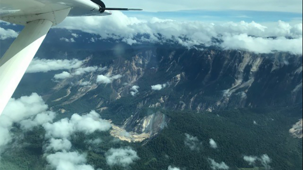
The Mw=7.5 earthquake in Papua New Guinea has generated remarkably little international publicity.  I noted shortly after the earthquake that landslides are likely to be a significant problem given the nature of the earthquake and the topography.  Information is slowly emerging now, and this is increasingly looking like a potential crisis to me.  The best data so far has been posted on the Facebook Page of Bernard James McQueen, who appears to be a helicopter pilot (?) from New Zealand, working in Papua New Guinea.  He has posted a series of images and two videos – check them out, they make deeply alarming viewing.  The videos appear to show very large numbers of very large valley blocking landslides.  This is one of the photographs:-

Papua New Guines landslide crisis

An extremely large planar rockslide in Papua New Guinea. Image posted on Facebook by Bernard James McQueen.

.

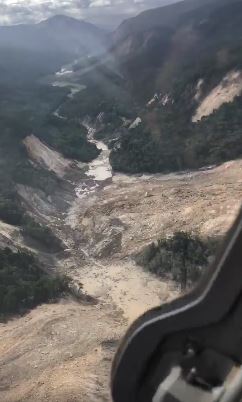
But this is not the only valley blocking landslide – this is a still from one of the videos:-

Papua New Guinea landslide crisis

Papua New Guinea landslide crisis: a still from a video posted on Facebook by Bernard James McQueen.

.

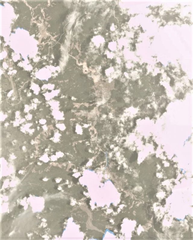
Satellite imagery of this area is quite difficult to obtain due to cloud cover, but the first images have now been captured by Planet Labs.  This covers only a small part of the earthquake affected area, and there is a considerable volume of cloud.  But the picture that is emerging is deeply alarming, with huge numbers of landslides, many of which look to be potentially valley blocking.  This is the area just to the east of Komo Station:-

Papua New Guinea landslide crisis

Planet Labs image of the a part of the area affected by the earthquake in Papua New Guinea.

.

Note the large flow-type landslide in the south of the image, and the multiple rockslides elsewhere.  Some of these slides appear to be very complex.

This is an exceptionally dangerous situation that needs urgent attention.  Papua New Guinea has high rainfall, so quake lakes may develop quickly.  Overtopping is extremely hazardous, especially when there are multiple landslide dams. There is an urgent need to evaluate the number and scale of the landslide dams, and the likely assets downstream that could be affected.

The last event on this scale was the 2008 Wenchuan earthquake.  In that case over 200 landslide dams needed attention; a feat that stretched even the mighty resources of the Chinese military.  The capacity to deal with this in Papua New Guinea is much lower.  This feels like a potential crisis to me.

Reference

Planet Team (2017). Planet Application Program Interface: In Space for Life on Earth. San Francisco, CA. https://api.planet.com

Source: https://blogs.agu.org/landslideblog/2018/02/28/papua-new-guinea-crisis/#.WpdbsngkGuk.twitter


__._,_.___

Posted by: Kim Noyes <kimnoyes@gmail.com>


__,_._,___

Tuesday, February 27, 2018

[Geology2] Update on landslides from Mw=7.5 PNG EQ


An update on landslides from the Mw=7.5 Papua New Guinea earthquake

An update on landslides from the Mw=7.5 Papua New Guinea earthquake

Information is slowly emerging regarding the impacts of landslides from the Mw=7.5 Papua New Guinea earthquake.  Unfortunately the area remains too cloudy to allow useful optical band satellite imagery to be obtained by Planet Labs, but I will keep an eye on this over the coming days.  Meanwhile media reports suggest that landslides may have been a significant factor – that is not a surprise in an upland area.  The most informative report that I have seen today is from the Post Courier, which indicates at least 31 fatalities, a large proportion of which may have been from landslides:-

Sketchy reports indicated that more than 13 people have been reportedly killed in the Southern Highlands capital Mendi, while another 18 people have also been reportedly killed in the most affected areas of Kutubu and Bosave…Unconfirmed reports from Mendi said that the earthquake was so powerful that people did not sleep, while there has been reports of landslides, landslips and sinkholes in several places and deaths.

RNZ has a more detailed report of the impact of the landslides themselves:

A police spokesman said there were also reports of entire hillsides coming down and whole villages being buried by landslides.  Mr Tens told RNZ Pacific from Mendi that rescuers were trying to reach four people buried in a landslide.  He said power and telecommunications were still out in most of the affected areas and the main roads into the region were cut off by landslips … According to police spokesman Dominic Kakas, at least 10 people died in landslips.  Superintendent Kakas said the quake and its after shocks have caused widespread movement of land in the provinces of Southern Highlands, Hela, Enga and Western Province.  He said reports are filtering through of extensive damage.  "To roads, landslips, entire mountains coming down, from reports some villages have been covered. The telephone lines the towers have been damaged, so yeah." … Earlier, Catholic priest Father Pius Hal told the Papua New Guinea Today website two children of a local government leader were among five killed by quake-triggered landslips in Mendi town.

MAF has published this image of the earthquake affected area, which also indicates extensive landslides:-

Papua New Guinea earthquake

MAF image of landslides triggered by the Papua New Guinea earthquake

.

As expected these are mostly disrupted shallow rockslides, but note the large, deeper-seated rock slope failure, with some evidence of flow, towards the bottom of the image.

Clearly the situation in the remote uplands of Papua New Guinea remains extremely uncertain; it is likely that it will be some days before we really understand the impacts of the this earthquake.  There is of course an urgent need to determine as to whether there are any valley-blocking landslides in the hills.

Source: https://blogs.agu.org/landslideblog/2018/02/27/papua-new-guinea-earthquake-2/


__._,_.___

Posted by: Kim Noyes <kimnoyes@gmail.com>


__,_._,___

Sunday, February 25, 2018

[californiadisasters] Emergency Manager’s Weekly Report 2-23-18


Good Afternoon Everyone,


This week's edition is now available on our new website at:

http://www.emergencymanagersweeklyreport.com/


Feel free to following the weekly report on social media at: 


Steve Detwiler

EM Weekly Report Editor


__._,_.___

Posted by: Steve Detwiler <steveorange2011@gmail.com>


Be sure to check out our Links Section at http://groups.yahoo.com/group/californiadisasters/links
Please join our Discussion Group at http://groups.yahoo.com/group/californiadisasters_discussion/ for topical but extended discussions started here or for less topical but nonetheless relevant messages.


__,_._,___

[Geology2] UPDATED: (M7.5) NEW GUINEA, PAPUA NEW GUINEA


M7.5 - NEW GUINEA, PAPUA NEW GUINEA

Preliminary Earthquake Report
Magnitude 7.5
Date-Time
  • 25 Feb 2018 17:44:44 UTC
  • 26 Feb 2018 03:44:44 near epicenter
  • 25 Feb 2018 09:44:44 standard time in your timezone
Location 6.149S 142.766E
Depth 35 km
Distances
  • 151 km (94 miles) ENE (71 degrees) of Lake Murray, New Guinea, PNG
  • 168 km (104 miles) WSW (258 degrees) of Mount Hagen, New Guinea, PNG
  • 273 km (169 miles) E (91 degrees) of Tanahmerah, Irian Jaya, Indonesia
  • 463 km (288 miles) SSE (150 degrees) of Jayapura, Irian Jaya, Indonesia
  • 612 km (380 miles) NW (307 degrees) of PORT MORESBY, Papua New Guinea
Location Uncertainty Horizontal: 7.1 km; Vertical 1.9 km
Parameters Nph = 57; Dmin = 603.0 km; Rmss = 1.16 seconds; Gp = 30°
Version =
Event ID us 2000d7q6

For updates, maps, and technical information
see: Event Page or USGS Earthquake Hazards Program
National Earthquake Information Center
U.S. Geological Survey


Disclaimer


--


__._,_.___

Posted by: Kim Noyes <kimnoyes@gmail.com>


__,_._,___

Thursday, February 22, 2018

[Volcano_Vista_HS] Daily Announcements Thursday, February 22, 2018


Good Morning Hawks


Today is Thursday, February 22, 2018


Please rise for the pledge


THIS WEEK IS SPREAD THE WORD TO END THE WORD.

We are asking people to pledge to stop saying the R-word as a starting point toward creating more accepting attitudes and communities for all people.  Language affects attitudes and attitudes affect actions.  Pledge today in lower E hall during lunch to use respectful, people-first language.


STUDENT SENATE will be collecting signatures in support of Stoneman Douglas High School in Florida. On Thursday during lunch we will have a pledge poster set up in F-hall to be sent to Stoneman Douglas High School.


TALENT SHOW: Auditions for the talent show will be tomorrow and Friday at lunch in the PAC. You must show up at the beginning of lunch. If we call your act and you aren't prepared, you WILL NOT be considered for the Talent Show on Feb. 28. Talent Show Lineup Will be Posted at the end of school Friday.
 

DECA is selling Yuda Bands for $7 at the DECA snack bar during lunch. These bracelets are handmade, super cool and most importantly all proceeds go back to Yuda bands to fund the education of a young boy from Guatemala. The boy directly impacted has aspirations of one day becoming a surgeon. If you buy a band you will help fund his schooling. Please come out and help us make a difference!  

 
COUNSELING:

APS is proud to be hosting the upcoming Hispanic Scholarship Fund (HSF) College 101 night, a free, bilingual (Spanish-English), workshop where students will receive valuable information about how to prepare, plan, and pay for a college education. SEE YOUR COUNSELOR FOR MORE INFORMATION.

 
ATHLETICS:

STAFF: a Pilates fitness class for staff members at 3:40 in the Dance Room. 


GIRLS BASKETBALL: will play at Rio Rancho at 5:30 on Friday.
 
BOYS BASKETBALL: will play on Saturday at 7:30 in The Ring of Fire
 
That's all for your morning announcements Hawks

Have a great day.

And remember

As always

It's Great to be a Hawk


__._,_.___

Posted by: grangergang@ymail.com


For more information, go to our web site: http://www.volcanovistahawks.com


__,_._,___

[ Volcano ] Smithsonian / USGS Weekly Volcanic Activity Report 13-19 December 2017


*******************************************************************************************************
Smithsonian / USGS Weekly Volcanic Activity Report 13-19 December 2017
*******************************************************************************************************


Sally Kuhn Sennert - Weekly Report Editor (kuhns@si.edu)
URL: http://www.volcano.si.edu/reports_weekly.cfm
 
 
New Activity/Unrest: Agung, Bali (Indonesia)  | Bezymianny, Central Kamchatka (Russia)  | Kanlaon, Philippines  | Klyuchevskoy, Central Kamchatka (Russia)  | Pacaya, Guatemala  | Shishaldin, Fox Islands (USA)  | Stromboli, Aeolian Islands (Italy)
 
Ongoing Activity: Aira, Kyushu (Japan)  | Cleveland, Chuginadak Island (USA)  | Dukono, Halmahera (Indonesia)  | Ebeko, Paramushir Island (Russia)  | Fuego, Guatemala  | Karymsky, Eastern Kamchatka (Russia)  | Kilauea, Hawaiian Islands (USA)  | Lopevi, Vanuatu  | Reventador, Ecuador  | Sabancaya, Peru  | Sheveluch, Central Kamchatka (Russia)  | Sinabung, Indonesia
 
 
The Weekly Volcanic Activity Report is a cooperative project between the Smithsonian's Global Volcanism Program and the US Geological Survey's Volcano Hazards Program. Updated by 2300 UTC every Wednesday, notices of volcanic activity posted on these pages are preliminary and subject to change as events are studied in more detail. This is not a comprehensive list of all of Earth's volcanoes erupting during the week, but rather a summary of activity at volcanoes that meet criteria discussed in detail in the "Criteria and Disclaimers" section. Carefully reviewed, detailed reports on various volcanoes are published monthly in the Bulletin of the Global Volcanism Network.
 
Note: Many news agencies do not archive the articles they post on the Internet, and therefore the links to some sources may not be active. To obtain information about the cited articles that are no longer available on the Internet contact the source.


New Activity/Unrest
 
 
Agung  | Bali (Indonesia)  | 8.343°S, 115.508°E  | Summit elev. 2997 m
 
PVMBG reported that during 13-19 December gray-and-white plumes rose as high as 2.5 km above Agung's crater rim and drifted W, N, and E; weather clouds and fog sometimes prevented visual observations. Incandescence from the crater was sometimes observed at night. The Alert Level remained at 4 (on a scale of 1-4), and the exclusion zones continued at a general 8-km radius and 10 km in the NNE, SE, S, and SW directions.
 
BNPB posted two map-view images of Agung, one from 20 October showing pre-eruptive conditions and one from 16 December showing the lava that had erupted onto the crater floor, noting that about 1/3 of the crater had been filled with an estimated 20 million cubic meters of lava.
 
Geologic Summary. Symmetrical Agung stratovolcano, Bali's highest and most sacred mountain, towers over the eastern end of the island. The volcano, whose name means "Paramount," rises above the SE caldera rim of neighboring Batur volcano, and the northern and southern flanks extend to the coast. The summit area extends 1.5 km E-W, with the high point on the W and a steep-walled 800-m-wide crater on the E. The Pawon cone is located low on the SE flank. Only a few eruptions dating back to the early 19th century have been recorded in historical time. The 1963-64 eruption, one of the largest in the 20th century, produced voluminous ashfall along with devastating pyroclastic flows and lahars that caused extensive damage and many fatalities.
 
Sources: Pusat Vulkanologi dan Mitigasi Bencana Geologi (PVMBG, also known as CVGHM) http://vsi.esdm.go.id/;
Badan Nacional Penanggulangan Bencana (BNPB) http://www.bnpb.go.id/
 
 
Bezymianny  | Central Kamchatka (Russia)  | 55.972°N, 160.595°E  | Summit elev. 2882 m
 
On 18 December hot avalanches on the SE flank of Bezymianny's lava dome were recorded by a webcam, prompting KVERT to raise the Aviation Color Code to Orange (the second highest level on a four-color scale). A strong explosion that started at 1555 on 20 December generated ash plumes that rose 10-15 km (32,800-49,200 ft) a.s.l., prompting KVERT to raise the Aviation Color Code to Red. Ash plumes were identified in satellite data drifting 85 km NE. Later that day satellite images indicted decreased activity; the Alert level was lowered back to Orange.
 
Geologic Summary. Prior to its noted 1955-56 eruption, Bezymianny had been considered extinct. The modern volcano, much smaller in size than its massive neighbors Kamen and Kliuchevskoi, was formed about 4700 years ago over a late-Pleistocene lava-dome complex and an ancestral edifice built about 11,000-7000 years ago. Three periods of intensified activity have occurred during the past 3000 years. The latest period, which was preceded by a 1000-year quiescence, began with the dramatic 1955-56 eruption. This eruption, similar to that of St. Helens in 1980, produced a large horseshoe-shaped crater that was formed by collapse of the summit and an associated lateral blast. Subsequent episodic but ongoing lava-dome growth, accompanied by intermittent explosive activity and pyroclastic flows, has largely filled the 1956 crater.
 
Source: Kamchatkan Volcanic Eruption Response Team (KVERT) http://www.kscnet.ru/ivs/kvert/index_eng.php
 
 
Kanlaon  | Philippines  | 10.412°N, 123.132°E  | Summit elev. 2435 m
 
PHIVOLCS reported between 1 and 7 volcanic earthquakes at Kanlaon were recorded each day during 2-8 December, prior to the phreatic eruption on 9 December. Only three events were detected on 10 December, and then the number increased to 155 the next day. The number of daily volcanic earthquakes increased to 578 on 13 December, rising to 1,007 the next day, and peaking at 1,217 on the 15th. The earthquake count dropped to 149 on 16 December before returning to six or less through 19 December. White steam plumes rose 800 and 300 m above the crater on 13 and 14 December, respectively. White plumes were diffuse on 15 December; weather clouds prevented views of the summit area during 16-18 December. Sulfur dioxide emissions were 603-687 tons per day during 13-14 December. The Alert Level remained at 2 (on a scale of 0-5).
 
Geologic Summary. Kanlaon volcano (also spelled Canlaon), the most active of the central Philippines, forms the highest point on the island of Negros. The massive 2435-m-high andesitic stratovolcano is dotted with fissure-controlled pyroclastic cones and craters, many of which are filled by lakes. The largest debris avalanche known in the Philippines traveled 33 km to the SW from Kanlaon. The summit of Kanlaon contains a 2-km-wide, elongated northern caldera with a crater lake and a smaller, but higher, historically active vent, Lugud crater, to the south. Historical eruptions from Kanlaon, recorded since 1866, have typically consisted of phreatic explosions of small-to-moderate size that produce minor ashfalls near the volcano.
 
Source: Philippine Institute of Volcanology and Seismology (PHIVOLCS) http://www.phivolcs.dost.gov.ph/
 
 
Klyuchevskoy  | Central Kamchatka (Russia)  | 56.056°N, 160.642°E  | Summit elev. 4754 m
 
Based on satellite observations KVERT reported that gas-and-steam plumes from Klyuchevskoy contained some ash and drifted about 95 km E and SW on 7 and 13 December, respectively. A weak thermal anomaly was visible on 11 December. The Aviation Color Code remained at Orange.
 
Geologic Summary. Klyuchevskoy (also spelled Kliuchevskoi) is Kamchatka's highest and most active volcano. Since its origin about 6000 years ago, the beautifully symmetrical, 4835-m-high basaltic stratovolcano has produced frequent moderate-volume explosive and effusive eruptions without major periods of inactivity. It rises above a saddle NE of sharp-peaked Kamen volcano and lies SE of the broad Ushkovsky massif. More than 100 flank eruptions have occurred during the past roughly 3000 years, with most lateral craters and cones occurring along radial fissures between the unconfined NE-to-SE flanks of the conical volcano between 500 m and 3600 m elevation. The morphology of the 700-m-wide summit crater has been frequently modified by historical eruptions, which have been recorded since the late-17th century. Historical eruptions have originated primarily from the summit crater, but have also included numerous major explosive and effusive eruptions from flank craters.
 
Source: Kamchatkan Volcanic Eruption Response Team (KVERT) http://www.kscnet.ru/ivs/kvert/index_eng.php
 
 
Pacaya  | Guatemala  | 14.382°N, 90.601°W  | Summit elev. 2569 m
 
INSIVUMEH reported that during 12-19 December Strombolian explosions at Pacaya's Mackenney cone ejected material as high as 100 m above the main cone. A 75-m-long lava flow on the NW flank was visible.
 
Geologic Summary. Eruptions from Pacaya, one of Guatemala's most active volcanoes, are frequently visible from Guatemala City, the nation's capital. This complex basaltic volcano was constructed just outside the southern topographic rim of the 14 x 16 km Pleistocene Amatitlán caldera. A cluster of dacitic lava domes occupies the southern caldera floor. The post-caldera Pacaya massif includes the ancestral Pacaya Viejo and Cerro Grande stratovolcanoes and the currently active Mackenney stratovolcano. Collapse of Pacaya Viejo between 600 and 1500 years ago produced a debris-avalanche deposit that extends 25 km onto the Pacific coastal plain and left an arcuate somma rim inside which the modern Pacaya volcano (Mackenney cone) grew. A subsidiary crater, Cerro Chino, was constructed on the NW somma rim and was last active in the 19th century. During the past several decades, activity has consisted of frequent strombolian eruptions with intermittent lava flow extrusion that has partially filled in the caldera moat and armored the flanks of Mackenney cone, punctuated by occasional larger explosive eruptions that partially destroy the summit of the growing young stratovolcano.
 
Source: Instituto Nacional de Sismologia, Vulcanologia, Meteorologia, e Hidrologia (INSIVUMEH) http://www.insivumeh.gob.gt/
 
 
Shishaldin  | Fox Islands (USA)  | 54.756°N, 163.97°W  | Summit elev. 2857 m
 
AVO reported that seismic and infrasound data from Shishaldin continued to indicate elevated activity during 13-19 December. Robust steaming was recorded by a webcam during 13-14 December; ice and poor weather conditions prevented views during the rest of the period. The Aviation Color Code remained at Yellow and the Volcano Alert Level remained at Advisory.
 
Geologic Summary. The beautifully symmetrical volcano of Shishaldin is the highest and one of the most active volcanoes of the Aleutian Islands. The 2857-m-high, glacier-covered volcano is the westernmost of three large stratovolcanoes along an E-W line in the eastern half of Unimak Island. The Aleuts named the volcano Sisquk, meaning "mountain which points the way when I am lost." A steady steam plume rises from its small summit crater. Constructed atop an older glacially dissected volcano, it is Holocene in age and largely basaltic in composition. Remnants of an older ancestral volcano are exposed on the west and NE sides at 1500-1800 m elevation. There are over two dozen pyroclastic cones on its NW flank, which is blanketed by massive aa lava flows. Frequent explosive activity, primarily consisting of strombolian ash eruptions from the small summit crater, but sometimes producing lava flows, has been recorded since the 18th century.
 
Source: US Geological Survey Alaska Volcano Observatory (AVO) http://www.avo.alaska.edu/
 
 
Stromboli  | Aeolian Islands (Italy)  | 38.789°N, 15.213°E  | Summit elev. 924 m
 
INGV reported after an effusive eruption during August-November 2014, activity at Stromboli remained at modest levels. In recent months however activity was characterized by frequent explosions from different vents on the crater terrace, punctuated by four major explosions (on 26 July, 23 October, 1 November, and 1 December 2017). Activity remained high after the last explosion, prompting authorities to restrict access to the summit areas. In the late morning on 15 December one of the vents began spattering, and by 1400 lava flows from two vents had begun to fill the crater depression. At 1430 the lava spilled onto the N flank of the Sciara del Fuoco. Spattering rapidly stopped later in the afternoon and the lava flows stopped advancing.
 
Geologic Summary. Spectacular incandescent nighttime explosions at this volcano have long attracted visitors to the "Lighthouse of the Mediterranean." Stromboli, the NE-most of the Aeolian Islands, has lent its name to the frequent mild explosive activity that has characterized its eruptions throughout much of historical time. The small, 924-m-high island is the emergent summit of a volcano that grew in two main eruptive cycles, the last of which formed the western portion of the island. The Neostromboli eruptive period from about 13,000 to 5000 years ago was followed by formation of the modern Stromboli edifice. The active summit vents are located at the head of the Sciara del Fuoco, a prominent horseshoe-shaped scarp formed about 5000 years ago as a result of the most recent of a series of slope failures that extend to below sea level. The modern volcano has been constructed within this scarp, which funnels pyroclastic ejecta and lava flows to the NW. Essentially continuous mild strombolian explosions, sometimes accompanied by lava flows, have been recorded for more than a millennium.
 
Source: Sezione di Catania - Osservatorio Etneo (INGV) http://www.ct.ingv.it/
 
 
Ongoing Activity
 
 
Aira  | Kyushu (Japan)  | 31.593°N, 130.657°E  | Summit elev. 1117 m
 
JMA reported that very small events occurred at Minamidake Crater (at Aira Caldera's Sakurajima volcano) on 14 and 18 December, and at Showa Crater on 16 December. The Alert Level remained at 3 (on a 5-level scale).
 
Geologic Summary. The Aira caldera in the northern half of Kagoshima Bay contains the post-caldera Sakurajima volcano, one of Japan's most active. Eruption of the voluminous Ito pyroclastic flow accompanied formation of the 17 x 23 km caldera about 22,000 years ago. The smaller Wakamiko caldera was formed during the early Holocene in the NE corner of the Aira caldera, along with several post-caldera cones. The construction of Sakurajima began about 13,000 years ago on the southern rim of Aira caldera and built an island that was finally joined to the Osumi Peninsula during the major explosive and effusive eruption of 1914. Activity at the Kitadake summit cone ended about 4850 years ago, after which eruptions took place at Minamidake. Frequent historical eruptions, recorded since the 8th century, have deposited ash on Kagoshima, one of Kyushu's largest cities, located across Kagoshima Bay only 8 km from the summit. The largest historical eruption took place during 1471-76.
 
Source: Japan Meteorological Agency (JMA) http://www.jma.go.jp/jma/
 
 
Cleveland  | Chuginadak Island (USA)  | 52.825°N, 169.944°W  | Summit elev. 1730 m
 
AVO reported that a small explosion at Cleveland was detected in seismic and infrasound data at 1817 on 17 December; no eruption plume was visible in satellite observations, though conditions were cloudy. The Aviation Color Code remained at Orange and the Volcano Alert Level remained at Watch.
 
Geologic Summary. Beautifully symmetrical Mount Cleveland stratovolcano is situated at the western end of the uninhabited, dumbbell-shaped Chuginadak Island. It lies SE across Carlisle Pass strait from Carlisle volcano and NE across Chuginadak Pass strait from Herbert volcano. Cleveland is joined to the rest of Chuginadak Island by a low isthmus. The 1730-m-high Mount Cleveland is the highest of the Islands of the Four Mountains group and is one of the most active of the Aleutian Islands. The native name for Mount Cleveland, Chuginadak, refers to the Aleut goddess of fire, who was thought to reside on the volcano. Numerous large lava flows descend the steep-sided flanks. It is possible that some 18th-to-19th century eruptions attributed to Carlisle should be ascribed to Cleveland (Miller et al., 1998). In 1944 Cleveland produced the only known fatality from an Aleutian eruption. Recent eruptions have been characterized by short-lived explosive ash emissions, at times accompanied by lava fountaining and lava flows down the flanks.
 
Source: US Geological Survey Alaska Volcano Observatory (AVO) http://www.avo.alaska.edu/
 
 
Dukono  | Halmahera (Indonesia)  | 1.693°N, 127.894°E  | Summit elev. 1229 m
 
Based on analyses of satellite imagery, wind model data, and notices from PVMBG, the Darwin VAAC reported that during 13-19 December ash plumes from Dukono rose to an altitude of 2.1 km (7,000 ft) a.s.l. and drifted NE, ENE, and E.
 
Geologic Summary. Reports from this remote volcano in northernmost Halmahera are rare, but Dukono has been one of Indonesia's most active volcanoes. More-or-less continuous explosive eruptions, sometimes accompanied by lava flows, occurred from 1933 until at least the mid-1990s, when routine observations were curtailed. During a major eruption in 1550, a lava flow filled in the strait between Halmahera and the north-flank cone of Gunung Mamuya. This complex volcano presents a broad, low profile with multiple summit peaks and overlapping craters. Malupang Wariang, 1 km SW of the summit crater complex, contains a 700 x 570 m crater that has also been active during historical time.
 
Source: Darwin Volcanic Ash Advisory Centre (VAAC) ftp://ftp.bom.gov.au/anon/gen/vaac/
 
 
Ebeko  | Paramushir Island (Russia)  | 50.686°N, 156.014°E  | Summit elev. 1103 m
 
Based on observations by volcanologists in Severo-Kurilsk (Paramushir Island), about 7 km E of Ebeko, explosions during 8-9 and 11 December generated ash plumes that rose as high as 2.3 km (7,500 ft) a.s.l. The Aviation Color Code remained at Orange (the second highest level on a four-color scale).
 
Geologic Summary. The flat-topped summit of the central cone of Ebeko volcano, one of the most active in the Kuril Islands, occupies the northern end of Paramushir Island. Three summit craters located along a SSW-NNE line form Ebeko volcano proper, at the northern end of a complex of five volcanic cones. Blocky lava flows extend west from Ebeko and SE from the neighboring Nezametnyi cone. The eastern part of the southern crater contains strong solfataras and a large boiling spring. The central crater is filled by a lake about 20 m deep whose shores are lined with steaming solfataras; the northern crater lies across a narrow, low barrier from the central crater and contains a small, cold crescentic lake. Historical activity, recorded since the late-18th century, has been restricted to small-to-moderate explosive eruptions from the summit craters. Intense fumarolic activity occurs in the summit craters, on the outer flanks of the cone, and in lateral explosion craters.
 
Source: Kamchatkan Volcanic Eruption Response Team (KVERT) http://www.kscnet.ru/ivs/kvert/index_eng.php
 
 
Fuego  | Guatemala  | 14.473°N, 90.88°W  | Summit elev. 3763 m
 
INSIVUMEH reported that activity at Fuego increased on 14 December. Vulcanian explosions generated ash plumes that rose 1.7 km above the crater and drifted 15 km NW, N, and NE. Ashfall was reported in San Miguel Dueñas, Alotenango (8 km ENE), and Ciudad Vieja (13.5 km NE). Explosions caused rumbling noises and shock waves that rattled nearby structures. The high level of activity continued during 14-15 December with 5-8 explosions per hour causing shock waves and rumbling. Ash plumes rose 1.2 km and drifted 20 km W and SW, and incandescent material was ejected 200-250 m above the crater. Ash fell in Panimaché I (8 km SW), Santa Sofía (12 km SW), Morelia (9 km SW), and El Porvenir. Explosions occurred at a rate of 4-6 per hour during 16-19 December, and weak shock waves were generated. Ash plumes rose as high as 1 km and drifted 12-15 km W and SW, causing ashfall in areas downwind including Panimaché I and II, Morelia, Santa Sofia, Sangre de Cristo, Palo Verde farm, and Yepocapa. Incandescent material was ejected 150-200 m above the crater.
 
Geologic Summary. Volcán Fuego, one of Central America's most active volcanoes, is one of three large stratovolcanoes overlooking Guatemala's former capital, Antigua. The scarp of an older edifice, Meseta, lies between 3763-m-high Fuego and its twin volcano to the north, Acatenango. Construction of Meseta dates back to about 230,000 years and continued until the late Pleistocene or early Holocene. Collapse of Meseta may have produced the massive Escuintla debris-avalanche deposit, which extends about 50 km onto the Pacific coastal plain. Growth of the modern Fuego volcano followed, continuing the southward migration of volcanism that began at Acatenango. In contrast to the mostly andesitic Acatenango, eruptions at Fuego have become more mafic with time, and most historical activity has produced basaltic rocks. Frequent vigorous historical eruptions have been recorded since the onset of the Spanish era in 1524, and have produced major ashfalls, along with occasional pyroclastic flows and lava flows.
 
Source: Instituto Nacional de Sismologia, Vulcanologia, Meteorologia, e Hidrologia (INSIVUMEH) http://www.insivumeh.gob.gt/
 
 
Karymsky  | Eastern Kamchatka (Russia)  | 54.049°N, 159.443°E  | Summit elev. 1513 m
 
KVERT reported that an ash plume from Karymsky was identified in satellite data drifting 50 km E on 14 December. The Aviation Color Code was raised to Orange (the second highest level on a four-color scale).
 
Geologic Summary. Karymsky, the most active volcano of Kamchatka's eastern volcanic zone, is a symmetrical stratovolcano constructed within a 5-km-wide caldera that formed during the early Holocene. The caldera cuts the south side of the Pleistocene Dvor volcano and is located outside the north margin of the large mid-Pleistocene Polovinka caldera, which contains the smaller Akademia Nauk and Odnoboky calderas. Most seismicity preceding Karymsky eruptions originated beneath Akademia Nauk caldera, located immediately south. The caldera enclosing Karymsky formed about 7600-7700 radiocarbon years ago; construction of the stratovolcano began about 2000 years later. The latest eruptive period began about 500 years ago, following a 2300-year quiescence. Much of the cone is mantled by lava flows less than 200 years old. Historical eruptions have been vulcanian or vulcanian-strombolian with moderate explosive activity and occasional lava flows from the summit crater.
 
Source: Kamchatkan Volcanic Eruption Response Team (KVERT) http://www.kscnet.ru/ivs/kvert/index_eng.php
 
 
Kilauea  | Hawaiian Islands (USA)  | 19.421°N, 155.287°W  | Summit elev. 1222 m
 
During 13-19 December HVO reported that the lava lake continued to rise, fall, and spatter in Kilauea's Overlook crater. Webcams recorded incandescence from long-active sources within Pu'u 'O'o Crater and from a small lava pond in a pit on the W side of the crater. Surface lava flows were active above and on the pali, and on the coastal plain.
 
Geologic Summary. Kilauea volcano, which overlaps the east flank of the massive Mauna Loa shield volcano, has been Hawaii's most active volcano during historical time. Eruptions are prominent in Polynesian legends; written documentation extending back to only 1820 records frequent summit and flank lava flow eruptions that were interspersed with periods of long-term lava lake activity that lasted until 1924 at Halemaumau crater, within the summit caldera. The 3 x 5 km caldera was formed in several stages about 1500 years ago and during the 18th century; eruptions have also originated from the lengthy East and SW rift zones, which extend to the sea on both sides of the volcano. About 90% of the surface of the basaltic shield volcano is formed of lava flows less than about 1100 years old; 70% of the volcano's surface is younger than 600 years. A long-term eruption from the East rift zone that began in 1983 has produced lava flows covering more than 100 sq km, destroying nearly 200 houses and adding new coastline to the island.
 
Source: US Geological Survey Hawaiian Volcano Observatory (HVO) http://hvo.wr.usgs.gov/
 
 
Lopevi  | Vanuatu  | 16.507°S, 168.346°E  | Summit elev. 1413 m
 
The Wellington VAAC noted that on 20 December a low-level eruption plume from Lopevi was visible in satellite and webcam images drifting NW at an altitude of 1.5 km (5,000 ft) a.s.l.
 
Geologic Summary. The small 7-km-wide conical island of Lopevi, known locally as Vanei Vollohulu, is one of Vanuatu's most active volcanoes. A small summit crater containing a cinder cone is breached to the NW and tops an older cone that is rimmed by the remnant of a larger crater. The basaltic-to-andesitic volcano has been active during historical time at both summit and flank vents, primarily along a NW-SE-trending fissure that cuts across the island, producing moderate explosive eruptions and lava flows that reached the coast. Historical eruptions at the 1413-m-high volcano date back to the mid-19th century. The island was evacuated following major eruptions in 1939 and 1960. The latter eruption, from a NW-flank fissure vent, produced a pyroclastic flow that swept to the sea and a lava flow that formed a new peninsula on the western coast.
 
Source: Wellington Volcanic Ash Advisory Center (VAAC) http://www.ssd.noaa.gov/VAAC/OTH/NZ/messages.html
 
 
Reventador  | Ecuador  | 0.077°S, 77.656°W  | Summit elev. 3562 m
 
IG reported that on most days during 12-19 December gas, steam, and ash plumes rose 600 m above Reventador's summit vent and drifted in multiple directions; weather clouds sometimes prevented visual observations. Crater incandescence was often visible, and blocks rolled as far as 600 m down the flanks. The Alert Level remained at Orange.
 
Geologic Summary. Reventador is the most frequently active of a chain of Ecuadorian volcanoes in the Cordillera Real, well east of the principal volcanic axis. The forested, dominantly andesitic Volcán El Reventador stratovolcano rises to 3562 m above the jungles of the western Amazon basin. A 4-km-wide caldera widely breached to the east was formed by edifice collapse and is partially filled by a young, unvegetated stratovolcano that rises about 1300 m above the caldera floor to a height comparable to the caldera rim. It has been the source of numerous lava flows as well as explosive eruptions that were visible from Quito in historical time. Frequent lahars in this region of heavy rainfall have constructed a debris plain on the eastern floor of the caldera. The largest historical eruption took place in 2002, producing a 17-km-high eruption column, pyroclastic flows that traveled up to 8 km, and lava flows from summit and flank vents.
 
Source: Instituto Geofísico-Escuela Politécnica Nacional (IG) http://www.igepn.edu.ec/
 
 
Sabancaya  | Peru  | 15.787°S, 71.857°W  | Summit elev. 5960 m
 
Observatorio Vulcanológico del Sur del IGP (OVS-IGP) and Observatorio Vulcanológico del INGEMMET (OVI) reported that explosive activity at Sabancaya decreased compared to the previous week; there was an average of 55 explosions recorded per day during 11-17 December. Seismicity was dominated by long-period events, with signals indicating emissions. Gas-and-ash plumes rose 2.5 km above the crater rim and drifted 50 km NW, W, and SW. The MIROVA system detected six thermal anomalies. The sulfur dioxide flux was high, at 2,200 tons per day on 15 December. The report noted that the public should not approach the crater within a 12-km radius.
 
Geologic Summary. Sabancaya, located in the saddle NE of Ampato and SE of Hualca Hualca volcanoes, is the youngest of these volcanic centers and the only one to have erupted in historical time. The oldest of the three, Nevado Hualca Hualca, is of probable late-Pliocene to early Pleistocene age. The name Sabancaya (meaning "tongue of fire" in the Quechua language) first appeared in records in 1595 CE, suggesting activity prior to that date. Holocene activity has consisted of Plinian eruptions followed by emission of voluminous andesitic and dacitic lava flows, which form an extensive apron around the volcano on all sides but the south. Records of historical eruptions date back to 1750.
 
Sources: Instituto Geológico Minero y Metalúrgico (INGEMMET) http://www.ingemmet.gob.pe/;
Instituto Geofísico del Perú (IGP) http://www.igp.gob.pe/
 
 
Sheveluch  | Central Kamchatka (Russia)  | 56.653°N, 161.36°E  | Summit elev. 3283 m
 
KVERT reported that a thermal anomaly over Sheveluch was identified in satellite images during 8, 11, and 13-14 December. The Aviation Color Code remained at Orange.
 
Geologic Summary. The high, isolated massif of Sheveluch volcano (also spelled Shiveluch) rises above the lowlands NNE of the Kliuchevskaya volcano group. The 1300 cu km volcano is one of Kamchatka's largest and most active volcanic structures. The summit of roughly 65,000-year-old Stary Shiveluch is truncated by a broad 9-km-wide late-Pleistocene caldera breached to the south. Many lava domes dot its outer flanks. The Molodoy Shiveluch lava dome complex was constructed during the Holocene within the large horseshoe-shaped caldera; Holocene lava dome extrusion also took place on the flanks of Stary Shiveluch. At least 60 large eruptions have occurred during the Holocene, making it the most vigorous andesitic volcano of the Kuril-Kamchatka arc. Widespread tephra layers from these eruptions have provided valuable time markers for dating volcanic events in Kamchatka. Frequent collapses of dome complexes, most recently in 1964, have produced debris avalanches whose deposits cover much of the floor of the breached caldera.
 
Source: Kamchatkan Volcanic Eruption Response Team (KVERT) http://www.kscnet.ru/ivs/kvert/index_eng.php
 
 
Sinabung  | Indonesia  | 3.17°N, 98.392°E  | Summit elev. 2460 m
 
Based on observations by PVMBG, satellite and webcam images, and model data, the Darwin VAAC reported that during 13-19 December ash plumes from Sinabung rose 4-5.5 km (13,000-18,000 ft) a.s.l. and drifted ENE, ESE, SE, and S. PVMBG noted that avalanches of hot material traveled as far as 3.5 km S, SE, ESE, and E.
 
Geologic Summary. Gunung Sinabung is a Pleistocene-to-Holocene stratovolcano with many lava flows on its flanks. The migration of summit vents along a N-S line gives the summit crater complex an elongated form. The youngest crater of this conical andesitic-to-dacitic edifice is at the southern end of the four overlapping summit craters. An unconfirmed eruption was noted in 1881, and solfataric activity was seen at the summit and upper flanks in 1912. No confirmed historical eruptions were recorded prior to explosive eruptions during August-September 2010 that produced ash plumes to 5 km above the summit.
 
Sources: Darwin Volcanic Ash Advisory Centre (VAAC) ftp://ftp.bom.gov.au/anon/gen/vaac/;
Pusat Vulkanologi dan Mitigasi Bencana Geologi (PVMBG, also known as CVGHM) http://vsi.esdm.go.id/


__._,_.___

[ Volcano ]


__,_._,___

[ Volcano ] Smithsonian / USGS Weekly Volcanic Activity Report, 20 December-26 December 2017


*******************************************************************************************************

Smithsonian / USGS Weekly Volcanic Activity Report, 20 December-26 December 2017

*******************************************************************************************************


Sally Kuhn Sennert - Weekly Report Editor (kuhns@si.edu
URL: 
http://volcano.si.edu/reports_weekly.cfm

New Activity/Unrest: Agung, Bali (Indonesia)  | Bezymianny, Central Kamchatka (Russia)  | Kanlaon, Philippines  | Klyuchevskoy, Central Kamchatka (Russia)  | Pacaya, Guatemala

Ongoing Activity: Aira, Kyushu (Japan)  | Bagana, Bougainville (Papua New Guinea)  | Dukono, Halmahera (Indonesia)  | Ebeko, Paramushir Island (Russia)  | Karymsky, Eastern Kamchatka (Russia)  | Kilauea, Hawaiian Islands (USA)  | Nevados de Chillan, Chile  | Oraefajokull, Iceland  | Sheveluch, Central Kamchatka (Russia)  | Sinabung, Indonesia

The Weekly Volcanic Activity Report is a cooperative project between the Smithsonian's Global Volcanism Program and the US Geological Survey's Volcano Hazards Program. Updated by 2300 UTC every Wednesday, notices of volcanic activity posted on these pages are preliminary and subject to change as events are studied in more detail. This is not a comprehensive list of all of Earth's volcanoes erupting during the week, but rather a summary of activity at volcanoes that meet criteria discussed in detail in the "Criteria and Disclaimers" section. Carefully reviewed, detailed reports on various volcanoes are published monthly in the Bulletin of the Global Volcanism Network.

Note: Many news agencies do not archive the articles they post on the Internet, and therefore the links to some sources may not be active. To obtain information about the cited articles that are no longer available on the Internet contact the source.


New Activity/Unrest

Agung  | Bali (Indonesia)  | 8.343°S, 115.508°E  | Summit elev. 2997 m

PVMBG reported that during 20-26 December gray-and-white plumes rose as high as 2 km above Agung's crater rim and drifted W and E; weather clouds and fog sometimes prevented visual observations. Incandescence from the crater was sometimes observed at night. BNPB reported that during 22-23 December events generated dense gray ash plumes that rose as high as 2.5 km above the crater rim and drifted NE. Ash fell on the flanks and in Tulamben, Kubu. As of 25 December there were 71,045 evacuees spread out in 239 shelters. The Alert Level remained at 4 (on a scale of 1-4), and the exclusion zones continued at a general 8-km radius and 10 km in the NNE, SE, S, and SW directions.

Geologic Summary. Symmetrical Agung stratovolcano, Bali's highest and most sacred mountain, towers over the eastern end of the island. The volcano, whose name means "Paramount," rises above the SE caldera rim of neighboring Batur volcano, and the northern and southern flanks extend to the coast. The summit area extends 1.5 km E-W, with the high point on the W and a steep-walled 800-m-wide crater on the E. The Pawon cone is located low on the SE flank. Only a few eruptions dating back to the early 19th century have been recorded in historical time. The 1963-64 eruption, one of the largest in the 20th century, produced voluminous ashfall along with devastating pyroclastic flows and lahars that caused extensive damage and many fatalities.

Sources: Pusat Vulkanologi dan Mitigasi Bencana Geologi (PVMBG, also known as CVGHM) http://vsi.esdm.go.id/Badan Nacional Penanggulangan Bencana (BNPB) http://www.bnpb.go.id/


Bezymianny  | Central Kamchatka (Russia)  | 55.972°N, 160.595°E  | Summit elev. 2882 m

KVERT reported that ash plumes from the 20 December explosive eruption at Bezymianny rose as high as 15 km (49,200 ft) a.s.l. and drifted 320 km NE. A thermal anomaly over the volcano was identified in satellite images during 21-22 December. The Aviation Color Code remained at Orange.

Geologic Summary. Prior to its noted 1955-56 eruption, Bezymianny had been considered extinct. The modern volcano, much smaller in size than its massive neighbors Kamen and Kliuchevskoi, was formed about 4700 years ago over a late-Pleistocene lava-dome complex and an ancestral edifice built about 11,000-7000 years ago. Three periods of intensified activity have occurred during the past 3000 years. The latest period, which was preceded by a 1000-year quiescence, began with the dramatic 1955-56 eruption. This eruption, similar to that of St. Helens in 1980, produced a large horseshoe-shaped crater that was formed by collapse of the summit and an associated lateral blast. Subsequent episodic but ongoing lava-dome growth, accompanied by intermittent explosive activity and pyroclastic flows, has largely filled the 1956 crater.

Source: Kamchatkan Volcanic Eruption Response Team (KVERT) http://www.kscnet.ru/ivs/kvert/index_eng.php


Kanlaon  | Philippines  | 10.412°N, 123.132°E  | Summit elev. 2435 m

PHIVOLCS reported that during 19-20 December there were 412 volcanic earthquakes detected at Kanlaon. A low-energy, explosion-type earthquake was detected at 0233 on 21 December associated with gas emissions from the summit area. Later in the day steam plumes rose 400 m and drifted NE. The number of daily volcanic earthquakes increased to 957 the next day and then decreased to less than 20 per day during 22-23 December; the daily count increased to 382 and 776 events on 24 and 25 December, respectively, and then decreased to 82 on 26 December. White plumes rose 300 m and drifted NE, NW, and SW on 21 December, and 700 m on 26 December; weather clouds prevented views on the other days. The Alert Level remained at 2 (on a scale of 0-5).

Geologic Summary. Kanlaon volcano (also spelled Canlaon), the most active of the central Philippines, forms the highest point on the island of Negros. The massive 2435-m-high andesitic stratovolcano is dotted with fissure-controlled pyroclastic cones and craters, many of which are filled by lakes. The largest debris avalanche known in the Philippines traveled 33 km to the SW from Kanlaon. The summit of Kanlaon contains a 2-km-wide, elongated northern caldera with a crater lake and a smaller, but higher, historically active vent, Lugud crater, to the south. Historical eruptions from Kanlaon, recorded since 1866, have typically consisted of phreatic explosions of small-to-moderate size that produce minor ashfalls near the volcano.

Source: Philippine Institute of Volcanology and Seismology (PHIVOLCS) http://www.phivolcs.dost.gov.ph/


Klyuchevskoy  | Central Kamchatka (Russia)  | 56.056°N, 160.642°E  | Summit elev. 4754 m

Based on satellite observations KVERT reported that gas-and-steam plumes from Klyuchevskoy contained some ash and drifted about 140 km E during 16-19 December. A weak thermal anomaly was visible on 16 December. The Aviation Color Code remained at Orange.

Geologic Summary. Klyuchevskoy (also spelled Kliuchevskoi) is Kamchatka's highest and most active volcano. Since its origin about 6000 years ago, the beautifully symmetrical, 4835-m-high basaltic stratovolcano has produced frequent moderate-volume explosive and effusive eruptions without major periods of inactivity. It rises above a saddle NE of sharp-peaked Kamen volcano and lies SE of the broad Ushkovsky massif. More than 100 flank eruptions have occurred during the past roughly 3000 years, with most lateral craters and cones occurring along radial fissures between the unconfined NE-to-SE flanks of the conical volcano between 500 m and 3600 m elevation. The morphology of the 700-m-wide summit crater has been frequently modified by historical eruptions, which have been recorded since the late-17th century. Historical eruptions have originated primarily from the summit crater, but have also included numerous major explosive and effusive eruptions from flank craters.

Source: Kamchatkan Volcanic Eruption Response Team (KVERT) http://www.kscnet.ru/ivs/kvert/index_eng.php


Pacaya  | Guatemala  | 14.382°N, 90.601°W  | Summit elev. 2569 m

INSIVUMEH reported that during 24-26 December Strombolian explosions at Pacaya's Mackenney cone ejected material as high as 50 m above the main cone. A 100-m-long lava flow on the W flank was visible.

Geologic Summary. Eruptions from Pacaya, one of Guatemala's most active volcanoes, are frequently visible from Guatemala City, the nation's capital. This complex basaltic volcano was constructed just outside the southern topographic rim of the 14 x 16 km Pleistocene Amatitlán caldera. A cluster of dacitic lava domes occupies the southern caldera floor. The post-caldera Pacaya massif includes the ancestral Pacaya Viejo and Cerro Grande stratovolcanoes and the currently active Mackenney stratovolcano. Collapse of Pacaya Viejo between 600 and 1500 years ago produced a debris-avalanche deposit that extends 25 km onto the Pacific coastal plain and left an arcuate somma rim inside which the modern Pacaya volcano (Mackenney cone) grew. A subsidiary crater, Cerro Chino, was constructed on the NW somma rim and was last active in the 19th century. During the past several decades, activity has consisted of frequent strombolian eruptions with intermittent lava flow extrusion that has partially filled in the caldera moat and armored the flanks of Mackenney cone, punctuated by occasional larger explosive eruptions that partially destroy the summit of the growing young stratovolcano.

Source: Instituto Nacional de Sismologia, Vulcanologia, Meteorologia, e Hidrologia (INSIVUMEH) http://www.insivumeh.gob.gt/


Ongoing Activity

Aira  | Kyushu (Japan)  | 31.593°N, 130.657°E  | Summit elev. 1117 m

JMA reported that very small events occurred at Minamidake Crater (at Aira Caldera's Sakurajima volcano) during 18-25 December. An event at 0514 on 25 December ejected material as far as 500 m from the crater. The Alert Level remained at 3 (on a 5-level scale).

Geologic Summary. The Aira caldera in the northern half of Kagoshima Bay contains the post-caldera Sakurajima volcano, one of Japan's most active. Eruption of the voluminous Ito pyroclastic flow accompanied formation of the 17 x 23 km caldera about 22,000 years ago. The smaller Wakamiko caldera was formed during the early Holocene in the NE corner of the Aira caldera, along with several post-caldera cones. The construction of Sakurajima began about 13,000 years ago on the southern rim of Aira caldera and built an island that was finally joined to the Osumi Peninsula during the major explosive and effusive eruption of 1914. Activity at the Kitadake summit cone ended about 4850 years ago, after which eruptions took place at Minamidake. Frequent historical eruptions, recorded since the 8th century, have deposited ash on Kagoshima, one of Kyushu's largest cities, located across Kagoshima Bay only 8 km from the summit. The largest historical eruption took place during 1471-76.

Source: Japan Meteorological Agency (JMA) http://www.jma.go.jp/jma/


Bagana  | Bougainville (Papua New Guinea)  | 6.137°S, 155.196°E  | Summit elev. 1855 m

Based on analyses of satellite imagery and model data, the Darwin VAAC reported that during 25-26 December ash plumes from Bagana rose to an altitude of 2.4 km (8,000 ft) a.s.l. and drifted NE.

Geologic Summary. Bagana volcano, occupying a remote portion of central Bougainville Island, is one of Melanesia's youngest and most active volcanoes. This massive symmetrical cone was largely constructed by an accumulation of viscous andesitic lava flows. The entire edifice could have been constructed in about 300 years at its present rate of lava production. Eruptive activity is frequent and characterized by non-explosive effusion of viscous lava that maintains a small lava dome in the summit crater, although explosive activity occasionally producing pyroclastic flows also occurs. Lava flows form dramatic, freshly preserved tongue-shaped lobes up to 50 m thick with prominent levees that descend the flanks on all sides.

Source: Darwin Volcanic Ash Advisory Centre (VAAC) http://www.bom.gov.au/info/vaac/advisories.shtml


Dukono  | Halmahera (Indonesia)  | 1.693°N, 127.894°E  | Summit elev. 1229 m

Based on analyses of satellite imagery, wind model data, and notices from PVMBG, the Darwin VAAC reported that during 20-25 December ash plumes from Dukono rose to an altitude of 2.1 km (7,000 ft) a.s.l. and drifted NE, E, SE, and S.

Geologic Summary. Reports from this remote volcano in northernmost Halmahera are rare, but Dukono has been one of Indonesia's most active volcanoes. More-or-less continuous explosive eruptions, sometimes accompanied by lava flows, occurred from 1933 until at least the mid-1990s, when routine observations were curtailed. During a major eruption in 1550, a lava flow filled in the strait between Halmahera and the north-flank cone of Gunung Mamuya. This complex volcano presents a broad, low profile with multiple summit peaks and overlapping craters. Malupang Wariang, 1 km SW of the summit crater complex, contains a 700 x 570 m crater that has also been active during historical time.

Source: Darwin Volcanic Ash Advisory Centre (VAAC) http://www.bom.gov.au/info/vaac/advisories.shtml


Ebeko  | Paramushir Island (Russia)  | 50.686°N, 156.014°E  | Summit elev. 1103 m

KVERT reported that on 16 December an ash plume from Ebeko was identified in satellite images drifting about 15 km SSW. A thermal anomaly was also visible. Volcanologists in Severo-Kurilsk (Paramushir Island), about 7 km E, observed ash plumes from explosions rising as high as 3.5 km (7,500 ft) a.s.l. during 18-19 and 21-22 December. The Aviation Color Code remained at Orange (the second highest level on a four-color scale).

Geologic Summary. The flat-topped summit of the central cone of Ebeko volcano, one of the most active in the Kuril Islands, occupies the northern end of Paramushir Island. Three summit craters located along a SSW-NNE line form Ebeko volcano proper, at the northern end of a complex of five volcanic cones. Blocky lava flows extend west from Ebeko and SE from the neighboring Nezametnyi cone. The eastern part of the southern crater contains strong solfataras and a large boiling spring. The central crater is filled by a lake about 20 m deep whose shores are lined with steaming solfataras; the northern crater lies across a narrow, low barrier from the central crater and contains a small, cold crescentic lake. Historical activity, recorded since the late-18th century, has been restricted to small-to-moderate explosive eruptions from the summit craters. Intense fumarolic activity occurs in the summit craters, on the outer flanks of the cone, and in lateral explosion craters.

Source: Kamchatkan Volcanic Eruption Response Team (KVERT) http://www.kscnet.ru/ivs/kvert/index_eng.php


Karymsky  | Eastern Kamchatka (Russia)  | 54.049°N, 159.443°E  | Summit elev. 1513 m

KVERT reported that an ash plume from Karymsky was identified in satellite data drifting 114 km ENE on 14 December. No further ash emissions were noted afterwards; the Aviation Color Code was lowered to Yellow (the second lowest level on a four-color scale) on 24 December.

Geologic Summary. Karymsky, the most active volcano of Kamchatka's eastern volcanic zone, is a symmetrical stratovolcano constructed within a 5-km-wide caldera that formed during the early Holocene. The caldera cuts the south side of the Pleistocene Dvor volcano and is located outside the north margin of the large mid-Pleistocene Polovinka caldera, which contains the smaller Akademia Nauk and Odnoboky calderas. Most seismicity preceding Karymsky eruptions originated beneath Akademia Nauk caldera, located immediately south. The caldera enclosing Karymsky formed about 7600-7700 radiocarbon years ago; construction of the stratovolcano began about 2000 years later. The latest eruptive period began about 500 years ago, following a 2300-year quiescence. Much of the cone is mantled by lava flows less than 200 years old. Historical eruptions have been vulcanian or vulcanian-strombolian with moderate explosive activity and occasional lava flows from the summit crater.

Source: Kamchatkan Volcanic Eruption Response Team (KVERT) http://www.kscnet.ru/ivs/kvert/index_eng.php


Kilauea  | Hawaiian Islands (USA)  | 19.421°N, 155.287°W  | Summit elev. 1222 m

During 20-26 December HVO reported that the lava lake continued to rise, fall, and spatter in Kilauea's Overlook crater. Webcams recorded incandescence from long-active sources within Pu'u 'O'o Crater and from a small lava pond in a pit on the W side of the crater. Surface lava flows were active above and on the pali, and on the coastal plain.

Geologic Summary. Kilauea volcano, which overlaps the east flank of the massive Mauna Loa shield volcano, has been Hawaii's most active volcano during historical time. Eruptions are prominent in Polynesian legends; written documentation extending back to only 1820 records frequent summit and flank lava flow eruptions that were interspersed with periods of long-term lava lake activity that lasted until 1924 at Halemaumau crater, within the summit caldera. The 3 x 5 km caldera was formed in several stages about 1500 years ago and during the 18th century; eruptions have also originated from the lengthy East and SW rift zones, which extend to the sea on both sides of the volcano. About 90% of the surface of the basaltic shield volcano is formed of lava flows less than about 1100 years old; 70% of the volcano's surface is younger than 600 years. A long-term eruption from the East rift zone that began in 1983 has produced lava flows covering more than 100 sq km, destroying nearly 200 houses and adding new coastline to the island.

Source: US Geological Survey Hawaiian Volcano Observatory (HVO) https://volcanoes.usgs.gov/observatories/hvo/


Nevados de Chillan  | Chile  | 36.868°S, 71.378°W  | Summit elev. 3180 m

On 19 December Servicio Nacional de Geología and Minería (SERNAGEOMIN) Observatorio Volcanológico de Los Andes del Sur (OVDAS) reported an increase in activity at Nevados de Chillán's Volcán Arrau dome complex during the previous three days. The activity was characterized by minor explosions occurring at a rate of four events per hour. Gas-and-tephra plumes rose 1 km above the crater rim. POVI reported that on 20 December explosions ejected incandescent material above the crater rim. The Alert Level remained at Yellow, the middle level on a three-color scale, and the public was reminded not to approach the craters within a 3-km radius.

Geologic Summary. The compound volcano of Nevados de Chillán is one of the most active of the Central Andes. Three late-Pleistocene to Holocene stratovolcanoes were constructed along a NNW-SSE line within three nested Pleistocene calderas, which produced ignimbrite sheets extending more than 100 km into the Central Depression of Chile. The largest stratovolcano, dominantly andesitic, Cerro Blanco (Volcán Nevado), is located at the NW end of the group. Volcán Viejo (Volcán Chillán), which was the main active vent during the 17th-19th centuries, occupies the SE end. The new Volcán Nuevo lava-dome complex formed between 1906 and 1945 between the two volcanoes and grew to exceed Volcán Viejo in elevation. The Volcán Arrau dome complex was constructed SE of Volcán Nuevo between 1973 and 1986 and eventually exceeded its height.

Sources: Proyecto Observación Villarrica Internet (POVI) http://www.povi.cl/Servicio Nacional de Geología y Minería (SERNAGEOMIN) http://www.sernageomin.cl/


Oraefajokull  | Iceland  | 64.05°N, 16.633°W  | Summit elev. 2010 m

On 22 December IMO reported that activity at Öræfajökull had been fairly stable during the previous weeks, though still above background levels; the Aviation Color Code remained at Yellow. In December the largest earthquake detected was a M2.5, but most events were smaller than M1. Earthquakes were located close to the caldera at depths between 2 and 10 km.

Geologic Summary. Öraefajökull, Iceland's highest peak, is a broad glacier-clad central volcano at the SE end of the Vatnajökull icecap. A 4 x 5 km subglacial caldera truncates the summit of the dominantly basaltic and rhyolitic volcano. The extensive summit icecap is drained through deep glacial valleys dissecting the SW-to-SE flanks. The largest-volume volcano in Iceland, 2119-m-high Öraefajökull was mostly constructed during Pleistocene glacial and interglacial periods. Holocene activity has been dominated by explosive summit eruptions, although flank lava effusions have also occurred. A major silicic eruption in 1362 CE was Iceland's largest historical explosive eruption. It and another eruption during 1727-28 were accompanied by major jökulhlaups (glacier outburst floods) that caused property damage and fatalities.

Source: Icelandic Met Office (IMO) http://en.vedur.is/


Sheveluch  | Central Kamchatka (Russia)  | 56.653°N, 161.36°E  | Summit elev. 3283 m

KVERT reported that a thermal anomaly over Sheveluch was identified in satellite images during 19-21 December. The Aviation Color Code remained at Orange.

Geologic Summary. The high, isolated massif of Sheveluch volcano (also spelled Shiveluch) rises above the lowlands NNE of the Kliuchevskaya volcano group. The 1300 cu km volcano is one of Kamchatka's largest and most active volcanic structures. The summit of roughly 65,000-year-old Stary Shiveluch is truncated by a broad 9-km-wide late-Pleistocene caldera breached to the south. Many lava domes dot its outer flanks. The Molodoy Shiveluch lava dome complex was constructed during the Holocene within the large horseshoe-shaped caldera; Holocene lava dome extrusion also took place on the flanks of Stary Shiveluch. At least 60 large eruptions have occurred during the Holocene, making it the most vigorous andesitic volcano of the Kuril-Kamchatka arc. Widespread tephra layers from these eruptions have provided valuable time markers for dating volcanic events in Kamchatka. Frequent collapses of dome complexes, most recently in 1964, have produced debris avalanches whose deposits cover much of the floor of the breached caldera.

Source: Kamchatkan Volcanic Eruption Response Team (KVERT) http://www.kscnet.ru/ivs/kvert/index_eng.php


Sinabung  | Indonesia  | 3.17°N, 98.392°E  | Summit elev. 2460 m

Based on observations by PVMBG, satellite images, and model data, the Darwin VAAC reported ash plumes from Sinabung during 20-23 December. The plumes rose 3.7-4.9 km (12,000-16,000 ft) a.s.l. during 20-21 December and drifted E and SW; weather clouds prevented estimates of plume altitudes on the other days.

Geologic Summary. Gunung Sinabung is a Pleistocene-to-Holocene stratovolcano with many lava flows on its flanks. The migration of summit vents along a N-S line gives the summit crater complex an elongated form. The youngest crater of this conical andesitic-to-dacitic edifice is at the southern end of the four overlapping summit craters. An unconfirmed eruption was noted in 1881, and solfataric activity was seen at the summit and upper flanks in 1912. No confirmed historical eruptions were recorded prior to explosive eruptions during August-September 2010 that produced ash plumes to 5 km above the summit.

Source: Pusat Vulkanologi dan Mitigasi Bencana Geologi (PVMBG, also known as CVGHM) http://vsi.esdm.go.id/


__._,_.___

[ Volcano ]


__,_._,___
Newer Posts Older Posts Home