Monday, September 30, 2019

[CaliforniaDisasters] South Ops News & Notes Update (9/30/2019-5:25PM)

Date
Time
News and Notes
09/30/2019 1725

Federal

Schaeffer, Vegetation Fire, Tulare County, Update
20 miles north of Kernville
Federal DPA, FRA Sequoia National Forest

  • 290 acres (+60 acres), grass and brush, 50% contained (+15% containment)
  • Incident submitting 1 ICS-209 daily at 1800

Taboose, Vegetation Fire, Inyo County, Update
9 miles south of Big Pine
Federal/State DPA, FRA/SRA, Inyo National Forest

  • 10,296 acres (+0 acres), grass and brush, 75% contained (+0% containment)
  • Area closures remain in effect
  • Incident submitting 1 ICS -209 weekly on Thursdays at 1800


09/30/2019 0702

Federal

Taboose, Vegetation Fire, Inyo County, Update
9 miles south of Big Pine
Federal/State DPA, FRA/SRA, Inyo National Forest

  • 10,296 acres (+0 acres), grass and brush, 75% contained (+0% containment)
  • Area closures remain in effect
  • Incident submitting 1 ICS -209 weekly on Thursdays at 1800

Schaeffer, Vegetation Fire, Tulare County, Update
20 miles north of Kernville
Federal DPA, FRA Sequoia National Forest

  • 230 acres (+0 acres), grass and brush, 35% contained (+0% containment)
  • Incident submitting 1 ICS-209 daily at 1800
Source: https://gacc.nifc.gov/oscc/news.php
_._,_._,_

Groups.io Links:

You receive all messages sent to this group.

View/Reply Online (#32407) | Reply To Group | Reply To Sender | Mute This Topic | New Topic

Your Subscription | Contact Group Owner | Unsubscribe [volcanomadness1@gmail.com]

_._,_._,_

[CaliforniaDisasters] North Ops News & Notes Update (9/30/2019-6:05PM)

     
Dates
Time
News and Notes
09/30/2019 1805 CA-SHF South Fire: 5,330 acres, 62% contained. Fire behavior remained minimal due to to high humidity and moisture over the fire area from previous days. The decrease in acres is due to better mapping. Road and trail closures remain in effect for the fire area. There is a threat to prehistoric trails, historic sites, and endangered Salmon. Fire may impact a Class 1 Airshed within the Yolla Bolla Wilderness.
Source: https://gacc.nifc.gov/oncc/news.php
_._,_._,_

Groups.io Links:

You receive all messages sent to this group.

View/Reply Online (#32406) | Reply To Group | Reply To Sender | Mute This Topic | New Topic

Your Subscription | Contact Group Owner | Unsubscribe [volcanomadness1@gmail.com]

_._,_._,_

[CaliforniaDisasters] Sundowner Wind Advisory (9/30/2019-AM)

URGENT - WEATHER MESSAGE  National Weather Service Los Angeles/Oxnard CA  1006 AM PDT Mon Sep 30 2019    CAZ039-052-010400-  /O.NEW.KLOX.WI.Y.0069.190930T2300Z-191001T1000Z/  Santa Barbara County South Coast-Santa Barbara County Mountains-  Including the cities of Santa Barbara, Montecito, Carpinteria,  San Marcos Pass, San Rafael Wilderness Area,  and Dick Smith Wilderness Area  1006 AM PDT Mon Sep 30 2019    ...WIND ADVISORY IN EFFECT FROM 4 PM THIS AFTERNOON TO 3 AM PDT  TUESDAY...    * WHAT...North winds 20 to 30 mph with gusts up to 45 mph    expected.    * WHERE...The Santa Ynez Range and the south coast of Santa    Barbara County, strongest from Montecito west. This includes    highways 101, 154, and 192.    * WHEN...From 4 PM this afternoon to 3 AM PDT Tuesday.    * IMPACTS...Gusty winds will make driving difficult and could    blow around unsecured objects. Tree limbs could be blown down    and a few power outages may result.    PRECAUTIONARY/PREPAREDNESS ACTIONS...    Use extra caution when driving, especially if operating a high  profile vehicle. Secure outdoor objects.


--
_._,_._,_

Groups.io Links:

You receive all messages sent to this group.

View/Reply Online (#32405) | Reply To Group | Reply To Sender | Mute This Topic | New Topic

Your Subscription | Contact Group Owner | Unsubscribe [volcanomadness1@gmail.com]

_._,_._,_

[CaliforniaDisasters] On This Date In California Weather History (September 30)

2018: Remnant moisture from Tropical Storm Rosa advanced into Southern California, bringing rain and widespread thunderstorms to the region, particularly the mountains and deserts.
In the Coachella Valley, a strong thunderstorm accumulated up to 3.5" of rain in 2 hours near Mecca.
One fatality resulted from the storm near Mecca.
An individual was swept away on Box Canyon road.

2010: Fresno set a record high of 101° F beating the old record of 99° F set back in 1991.
This old record was the only record high maximum temperature that was below 100° F degrees for September.
All of the record high maximum temperatures for Fresno for the month of September are now in the triple digits.

2001: Tropical Depression Juliette ignited thunderstorms in the inland valleys, mountains and deserts on this day and on 10/1. 
Flooding was reported in Beaumont.
One was killed by lightning at Cuyamaca Rancho State Park.
In the Coachella Valley, strong downburst  winds downed trees and produced a dust storm that reduced visibility to near zero.

1988: Fresno set a high of 99° F, making it the only day during the month of September the city has never seen a triple digit high temperature.

1983: Low pressure off the coast ignited thunderstorms over the L.A. Basin. The storms produced two tornadoes, one in Walnut Park and a second in Hawthorne.
The Hawthorne tornado was on the ground for 1.4 miles, during which time it unroofed 8 homes and damaged 60 others.
Winds were estimated at 100 mph (ranking F2on the Fujita scale).

1982: It was 49° F in Borrego Springs, the lowest temperature on record for September.
This also occurred on 9.27.1986 and 9.30.1971.

1971: Caribbean Sea Hurricane Irene crossed Nicaragua and reformed in the eastern Pacific as Hurricane Olivia.
Olivia recurved to the northeast and made landfall in central Baja California with rainfall of up to 1" in the southern deserts on this day and on 10.1.
This occurred during the La Niña of 1970-71.

1971:  4" of snow fell at Donner Memorial State Park near Truckee.

1970: Drought in Southern California climaxed and hot Santa Ana winds blew starting on 9/25 and ending on this day.
Winds peaked at 60 mph at Cuyamaca.
The winds downed powerlines, which sparked the Laguna Fire, one of the largest wildfires in California history.
8 people were killed, 382 homes were destroyed, and 175,425 acres were burned.
The fire consumed whole communities of interior San Diego County.
500,000 acres were burned and caused fifty million dollars in damage.

1950: Livermore had a low temperature of 35
° F.

1950: Fresno reached a chilly 37° F for a low temperature, establishing a record low for the month.
This is also the earliest low temperature in the season below 40° F on record in Fresno.
Frost was reported in the Fresno area as well for the earliest time ever.

1950: The morning low temperature at Reno, NV was 21° F.

1946: Woodfords (Alpine Co.) recorded 1.27" of precipitation.

1946: A tropical storm moved northward into northern Baja California and dissipated with rainfall of up to 4" in the mountains on this day and exceeding 4" in the mountains on 10.1.
This occurred during the El Niño of 1946-47.

1932: Flash flood at Woodfords (Alpine Co. near Markleeville) generated a 45-foot wall of water which killed 15 people and destroyed several locomotives.
Flash flooding also occurred in the Tehachapi Mountains.

1932: Remnants from a tropical system helped to produce 1.1" of rain in Las Vegas, NV, causing several roads to become flooded and impassable.

1932: Heavy rains starting on 9.28 and ending on 10.1 came from a dying tropical cyclone.
It brought flooding to parts of the mountains and deserts of Southern California.
4.38" of rain fell at Tehachapi in 7 hours on this day.
Floods in Tehachapi resulted in 15 deaths.

1930: It was 46° in Palm Springs, the lowest temperature on record for September.

1921: 1.23" of rain fell in San Diego, the greatest daily amount on record for September.
1.5" fell on this day and on 10.1, the greatest 24-hour total on record for September.

1921: A tropical storm crossed the Baja peninsula southwest of Yuma, AZ, and moved up the Colorado River Valley.
Several stations along the Colorado River reported in excess of 3" of rain, including 3.65" at Yuma.
Other amounts included 1.50" at Flagstaff, 1.24" at Prescott, 0.68" at Tucson, and 0.56" at Phoenix, AZ.

1894: Fresno had its' coldest maximum on record for the month of September – the high this day reached only 56° F.

Source: NWS San Francisco/Monterey, Hanford, Reno, Las Vegas, Phoenix, & San Diego

--
_._,_._,_

Groups.io Links:

You receive all messages sent to this group.

View/Reply Online (#32404) | Reply To Group | Reply To Sender | Mute This Topic | New Topic

Your Subscription | Contact Group Owner | Unsubscribe [volcanomadness1@gmail.com]

_._,_._,_

[CaliforniaDisasters] Outages Meant to Deter Wildfires Burden Rural California Counties

SAN FRANCISCO - When California's largest utility warned it would cut power to thousands to prevent its equipment from starting wildfires during warm, windy weather, officials in the wealthy wine region of Sonoma County sprang into action.

They declared a state of emergency and called up additional first responders who could direct traffic or take vulnerable residents to places with electricity.

Nearly 200 miles (275 kilometers) north, officials in rural Butte County simply posted Pacific Gas & Electric information online about which neighborhoods would be affected and what to do with perishable food.

Rich county, poor county

Both counties had communities decimated in wildfires ignited by power lines in recent years. They face the long-term prospect of frequent power shutoffs during fire season as PG&E and other utilities try to prevent their equipment from sparking blazes like the one last year that killed 85 people and nearly destroyed the Butte County town of Paradise.

More populated, wealthier counties have adapted their emergency plans to respond to the new reality of thousands of residents losing power for an undetermined amount of time. But the preventive outages are proving to be a burden to smaller, poorer counties without resources to set up places for people to cool off or mobilize staff to deal with emergencies if outages stretch past two days.

"The outages are to avoid an emergency and a fire disaster, but there are no resources that counties can access to make sure that people are at a cooling station or get the transportation they need to get there," said Darby Thomas, deputy executive director of the California State Association of Counties.

Millions yet to be doled out

California lawmakers this year set aside $75 million to prepare local governments for the outages, but officials have yet to decide how to distribute the money.

The outages are new for PG&E and Southern California Edison, which together provide power in 55 of California's 58 counties. The utilities and county officials are working together to figure out their roles, but a lack of standards has led to disparate responses.

This week, PG&E shut off power to more than 48,000 customers in seven

counties in wine country and the Sierra Nevada foothills as the humidity plunged, temperatures rose and winds kicked up — a combination that has fueled some of the most destructive blazes in California history.

The outages lasted less than a day, and no major problems were reported.

Wine country prepares

In Sonoma County, PG&E cut power to 700 people in the Santa Rosa area, where a massive blaze in October 2017 killed 22 people and destroyed more than 5,000 homes.

The county started planning for power outages shortly after regulators approved them in May, emergency management director Chris Godley said.

"Just like we prepare for an earthquake, or fire season, or flood season, we also prepared for the de-energization because if the power will be out for more than 48 hours, it's really an emergency for the community," he said.

The county's outage plan calls for opening facilities with air conditioning, adding more police patrols to direct traffic after streetlights go out and sending workers to check on those who are sick or immobile.

"Our response philosophy is to ensure maximum and full response immediately because we don't know the level and scope of what's going to happen," Godley said.

Elsewhere, residents on their own

In Butte County, where 24,000 customers lost power twice this week, authorities ensured backup generators worked, had staffers ready in case they needed to check on vulnerable people and shared PG&E updates on social media. They planned to rely on two PG&E cooling centers.

"Our role is to make sure the information gets out there because it's really PG&E's thing," county spokeswoman Miranda Bowersox said.

Lake County, home to 60,000 people in the Sierra foothills where wildfires in recent years killed four people and burned hundreds of buildings, emergency officials have spent $500,000 buying and installing generators that can power police, fire, water and sewage services.

It doesn't have the resources to do much more than ensure government buildings are operating during an outage, said Dale Carnathan, county emergency services manager.

As in Butte County, Carnathan said Lake County's focus has been on telling people the location of outages, advising them to buy nonperishable food and generators, and urging them to charge their phones.

"What people need to understand is that local government is not going to be able to come to their rescue," he said. "We need them to take responsibility for their own safety and security, at least for the short term, because we're going to be in the same boat they are in."

Long outages a problem

Though the outages were brief this week, those longer than two days can strain communities, said Thomas of the counties association. Even after the weather improves, there can be delays as utilities inspect every line before restoring power.

A lot still needs to be done to help counties prepare, including drawing up plans to help people with medical issues or disabilities, she said.

"Most of these counties haven't had to deal with this before," Thomas said. "We're hoping that some of the funds go toward not only buying generators but also helping them plan for these emergencies so they are able to respond."


--
_._,_._,_

Groups.io Links:

You receive all messages sent to this group.

View/Reply Online (#32403) | Reply To Group | Reply To Sender | Mute This Topic | New Topic

Your Subscription | Contact Group Owner | Unsubscribe [volcanomadness1@gmail.com]

_._,_._,_

[CaliforniaDisasters] Missouri man charged with setting 13 fires in California

Missouri man charged with setting 13 fires in California

| Posted on September 27, 2019

Freddie Graham
A Missouri man has been charged with 13 felony counts of wildland fire arson and two additional counts of arson committed during a state of emergency. In March, Gov. Gavin Newsom, declared an emergency status in California for the year's wildfire season.

According to Santa Clara County prosecutors, Freddie Owen Graham of Lone Jack, Missouri flew to San Jose, California, rented a car, and over a period of two days set 13 fires in the Milpitas area. The largest one, the Reservoir Fire, burned 128 acres.

Investigators allege Mr. Graham used a lighter to set napkins from fast food restaurants on fire and threw them into the vegetation. A good citizen saw him up on a hill, took photos and reported his license plate number to CAL FIRE officials who traced the car to the Hertz outlet at the San Jose Airport. Mr. Graham was arrested while turning in the car.

There is a report by Fox4KC that when the investigators arrived at the airport they discovered that the car seen at the fire had been turned in, but the same person, Mr. Graham, came back and rented another.

Mr. Graham is also facing an arson charge in Lone Jack for setting fire to bales of hay on a tractor trailer August 12, 2018.


--
_._,_._,_

Groups.io Links:

You receive all messages sent to this group.

View/Reply Online (#32402) | Reply To Group | Reply To Sender | Mute This Topic | New Topic

Your Subscription | Contact Group Owner | Unsubscribe [volcanomadness1@gmail.com]

_._,_._,_

[CaliforniaDisasters] How to protect yourself from nuclear radiation

Duck and cover? More like: Go inside and stay inside.

a nuclear explosion from a nuclear weapons testSure, nuclear explosions are terrifying, but you're more likely to be exposed to radiation through more mundane means.U.S. Federal Emergency Management Agency

On Aug. 8, residents of Severodvinsk, Russia, witnessed a tremendous explosion. Experts across the world are still trying to piece together exactly what happened—and Russian media outlets are demanding answers from the Kremlin—but it seems clear the explosion came from somewhere close to the Russian Navy's nearby missile-testing range.

The current theory is that the blast, which killed five scientists and blanketed the immediate region with a still-unknown amount of radiation, most likely involved a missile equipped with a miniature nuclear reactor.

Though the incident doesn't seem to have involved a live nuclear warhead, submarines armed with such weapons are a key component of Russia's nuclear deterrence strategy—same as in the United States. And following the collapse earlier this year of the Intermediate-Range Nuclear Forces treaty that limited weapons-testing, the world may see more and more nuclear weapons tests. With them comes the increased likelihood of accidents and exposure to radiation.

As anyone who watched HBO's Chernobyl miniseries this spring can tell you, massive releases of radiation are also possible in entirely peaceful scenarios. Maybe the next catastrophe will be the result of engineering mistakes and human error, like Chernobyl was. Or perhaps a natural disaster will lead to a nuclear accident, like the earthquake that triggered reactor meltdowns at Japan's Fukushima Daiichi Nuclear Power Plant in 2011.

Know your risk

Maybe the likelihood of being affected by a nuclear event seems too low for you to even consider worrying, but know that the most likely scenario involves exposure to radiation from a nearby source. So ascertain if there's one nearby. If you live in Pennsylvania, for example, you probably already know if your home is one of the 40 percent of Keystone State residences exposed to radon gas. Those who live near an old uranium mine, a disused weapons-testing or weapons-assembly plant, or any of the nearly 100 radioactive locations on the Department of Energy's "legacy management" list are probably equally well-informed.

The same is true with commercial nuclear power plants. If you're one of the roughly 3 million Americans living within 10 miles of an energy-generating reactor, you're inside an "emergency planning zone" designated by the Nuclear Regulatory Commission.

But if there is actually a mishap at a reactor, the effects will be much more widespread, says Edwin Lyman, a physicist and nuclear power safety and security expert at the Union of Concerned Scientists. Some experts say anyone within 50 miles of a nuclear power plant or research facility should be prepared to take immediate action. That means 65 percent of Americans, including nearly every resident of New York City, could be at risk.

"You can't count on the industry or the Nuclear Regulatory Commission to fully evaluate the potential consequences, because they put a lid on the events they actually worry about," Lyman says. "That also puts people at risk." The NRC—who's had a long history of friction with the UCS—challenges Lyman's claims and says it has strict guidelines to let people know in less than an hour when a significant event takes place in nuclear power plants or research facilities accross the country. "The idea that the NRC prevents the public from learning about events at nuclear power plants, is incorrect," says Scott Burnell, public affairs officer at the commission.

In either case, it's easy to figure out by yourself if you live closer than 50 miles from a nuclear reactor. It may be a little more challenging to determine if there's a weapons or enrichment facility nearby, but it can be done. Most weapons-assembly and research facilities, like the Idaho National Laboratory, are in relatively isolated areas and are not exactly open to the public. Though exactly what they do is a matter of national security, their existence isn't a state secret.

Knowing whether you're in an area likely to be targeted by a nuclear weapon is much easier: If you live somewhere populated, or with important military installations, you are.

And while understanding your risk doesn't mean we should all be rushing to construct fallout shelters and stock up on Geiger counters, it's still important to know how to react. The chance of a nuclear disaster may be low, but the cost is profound.

"They are events that may never happen, but if they do happen, the extent of the damage—in human, economic, and social terms—may be extraordinary," says Alex Wellerstein, a professor at the Stevens Institute of Technology and an expert on the history of nuclear weapons.

a ferris wheel in Pripyat, Ukraine, near ChernobylFifty thousand people used to live in this city. Now, it's a ghost town.Ilja Nedilko via Unsplash

In most natural disasters, the first rule is to stay informed and follow instructions from local authorities. But in the event of a nuclear threat, government officials may not be the best source for accurate information and appropriate measures, experts say. As the Russians are currently demonstrating, secrecy and obfuscation characterize every nuclear weapons program (including the United States'), and, according to experts contacted for this article, there remains an imperative to downplay the severity of commercial accidents—officials simultaneously want to avoid panic and preserve the industry's reputation.

That means it's largely up to you to protect yourself. Preparedness and awareness are key, but even if you've just moved and have barely unpacked, there are measures you can take to reduce your risk of radiation exposure and (hopefully) your likelihood of suffering radiation sickness or developing cancer.

Understand radiation

First, try to pierce through the confusion. Know the difference between radioactive material and radiation itself. Many natural things are radioactive—the granite at Grand Central Station in New York City, for example, has minute traces of uranium—but you'll only be in danger if you are exposed to a constant level of radiation over a long period of time, or if the radioactive material emanates a significant amount of radiation.

Radiation is energy: the waves and particles cast into the environment by a radioactive object or nuclear event. Anything more than 50,000 millirem—a massive dose compared to the 620 millirem absorbed annually by the average American—tends to start to kill cells.

In short: Nuclear events are short-lived, but incredibly dangerous; radioactive objects are more common, but far less threatening.

a damaged nuclear radiation hazard warning sign in Pripyat, UkraineEvents like Chernobyl don't last long, but their devastating effects can continue for decades.Ilja Nedilko via Unsplash

One direct countermeasure you can take when exposed to radiation is to pop a tablet of pop a tablet of potassium iodide—the FDA has specific guidelines to do so. If you live near a reactor, your state might already stockpile the stuff, but not every state does. You can also buy your own. Taking a potassium iodide pill in the first few hours after an event may protect your thyroid gland from absorbing too much radioactive iodine, but it won't be much help in protecting the rest of your internal organs.

Knowing how radiation works is also helpful. It's invisible—you can't see, smell, or taste it—but you can learn how it moves. Radioactive contamination travels by water—as in rain or streams—or air, so think of it like snow or ash and treat it the same way, Wellerstein says.

Which means…

Get inside and stay there

Even if you live in a major population center that's hit with a relatively low-yield nuclear weapon of about 10 kilotons—smaller than the bombs dropped on Hiroshima and Nagasaki, and a tiny fraction of the nine-megaton Cold War-era bombs designed to destroy Soviet cities—you can survive if you take prudent action.

"And if you are very, very lucky," says Ferenc Dalnoki-Veress, a professor at the James Martin Center for Nonproliferation Studies at the Middlebury Institute of International Studies.

If you're not already dead, on fire, or in a building that is—very likely outcomes of a nearby nuclear explosion—you've got work to do.

As quickly as you can, get inside and stay there. For days, if necessary.

a dark, creepy basement with some coolers in itNormally, you probably wouldn't want to hang out in a place like this. But during a nuclear event, it might feel like a five-star hotel.Isaac Jarnagin via Unsplash

Places like schools or government buildings are the best places to shelter. These are more likely to be built of concrete, masonry, and steel, which makes them better at keeping ionizing radiation away than, say, a wood-framed house. Even small American towns and cities have post offices or libraries made of stone. The more insulation between you and the outdoors, the better—a basement is preferable to a top floor, and a room away from windows or doors is superior to a balcony.

The good news is that the half-life of a nuclear event's most dangerous particles is a few days—maybe a week. That means staying indoors for up to three days may be enough to significantly reduce your risk of absorbing a damaging or fatal dose, but it also means you ought to have stockpiled enough canned food and water for a long weekend's worth of living-room camping.

Just in case, you should be doing that anyway: Experts say you should be prepared to survive on your own for up to 72 hours after a disaster—about the time it takes authorities to muster an "official" response.

Get clean

If you were outside when the event occured, you can reduce your radiation exposure by doing basic chores, like laundering your clothes and taking a shower. Radioactive material that beams damaging alpha, beta, and gamma particles into your body clings to clothing and skin, but it can be washed off, reducing your exposure. If you're already the type who removes your shoes before entering your house and tracking dirt around, you're a step ahead.

Improve your shelter

a boarded up house on open landAesthetics really don't matter when you're trying to hide from nuclear radiation.Dan Meyers via Unsplash

Sure, a wood-framed house with drafty windows and cracks in the walls isn't great shelter, but you can make it slightly better shelter by staying away from anything that's letting air (and radiation) in, or closing them. Something as simple as hanging a sheet over a window or placing plywood over a door can still make a difference.

"Any space you can put in between yourself and the event, anything—even just air, or a few feet of wood—is going to absorb a little bit more of the radiation, and so what you'll get is a much smaller dose," Wellerstein says. Even if radiation levels are seriously high, you may reduce them by a factor of 10—so instead of increased risk of both cancer and radiation sickness, you may just slightly increase your cancer risk. Better!

Be prepared to leave and decide if you should

Now that you're inside, in fresh clothes, and away from windows, you need to decide how long to stay and whether it's a safe place to be.

If you receive an evacuation order from local authorities, you should pay attention to it, but know that such orders are sometimes issued prematurely, not at all, or too late. Since nuclear events are both rare and potentially catastrophic, as well as opaque and confusing, an incorrect response that triggers a mass panic could be worse than the actual event. "It's really tricky for a government to figure out what to do," Wellerstein says.

That leaves you with the responsibility of deciding whether to stay put or seek shelter elsewhere. Whether you choose to wait for an official evacuation order, or decide against it, remember you will still likely want to wait at least 72 hours after an event before you go outside again. That said, if you have reliable information that a radioactive plume is headed your way, you may wisely choose to grab your things and go.

Go shopping

Once the radioactive plume has passed, you should abandon that year's garden. Don't eat stuff that's been outside, and if you had clothes drying on a clothesline at the time of the event, don't wear them. It's all likely to have been contaminated with radioactive material, so eating or wearing any of it would probably put a source of radiation directly on or in your body, raising the chance that you absorb a dangerous dose.

These are all viable options to protect yourself if the nuclear event is not too big and not a full-scale exchange of nuclear weapons. If the latter happens and you manage to survive the blast, society will most likely collapse and you'll need a lifetime's worth of DIY guides to rebuild civilization and survive in a post-apocalyptic hellscape.


--
_._,_._,_

Groups.io Links:

You receive all messages sent to this group.

View/Reply Online (#32401) | Reply To Group | Reply To Sender | Mute This Topic | New Topic

Your Subscription | Contact Group Owner | Unsubscribe [volcanomadness1@gmail.com]

_._,_._,_

[CaliforniaDisasters] As Seen on TV: Could a Hollywood-Sized Tsunami Hit Santa Monica?

As Seen on TV: Could a Hollywood-Sized Tsunami Hit Santa Monica?


On Monday night, the Fox Television show "9-1-1" was based around a 50-foot tsunami hitting the Southern California coast near Santa Monica.  The show employed the giant water tanks that were used to create the effects in the movie "Titanic." The episode ended (to be continued!) with a cresting wave about to engulf the pier.

Entertaining stuff, to be sure. But reality? Could a tsunami this size really happen in Southern California?

Unless it's caused by an asteroid plunging into the ocean, probably not.

The California Geological Survey has worked with other experts in the tsunami field for over a decade to determine the maximum tsunami threats which could impact each section of the California coast.  There are earthquake and landslide sources offshore of Southern California which could generate a tsunami that hits the coast in 10 minutes. However, there are no tsunami sources capable of creating the giant "tidal wave" portrayed in the TV show.

The largest locally-sourced tsunami which could hit Santa Monica would be about 8 feet tall, which could flood the beach and injure people if they do not immediately evacuate to higher ground.

The maximum tsunami possible in Santa Monica is about 15 feet high. Such a tsunami would be generated by a massive earthquake off the coast of Alaska, so people in Southern California would get 5-6 hours of warning — plenty of time to get to a higher, safe location.

The reality of tsunami hazards is not always represented correctly by Hollywood. But that doesn't mean they're not dangerous or that folks who live near or visit the beach shouldn't learn about and prepare for future tsunamis.

ARE YOU PREPARED FOR A TSUNAMI?

If you really want to see how much flooding could occur along the California coast from the largest tsunamis, visit www.tsunami.ca.gov and take a look at our tsunami inundation maps for evacuation planning for your area of interest.

So, we hoped you enjoyed the TV show – the next episode, "Sink or Swim" – airs at 8 p.m. Monday, but make sure you understand the realistic tsunami hazards you could face and be prepared for them.


--
_._,_._,_

Groups.io Links:

You receive all messages sent to this group.

View/Reply Online (#32400) | Reply To Group | Reply To Sender | Mute This Topic | New Topic

Your Subscription | Contact Group Owner | Unsubscribe [volcanomadness1@gmail.com]

_._,_._,_

[CaliforniaDisasters] Fighting Fires with Social Media

Wildfires spread quickly, but so do tweets. Alumnus and Cal Fire Chief Jonathan Cox explains why he uses social media to communicate in a crisis.

By Robyn Kontra Tanner

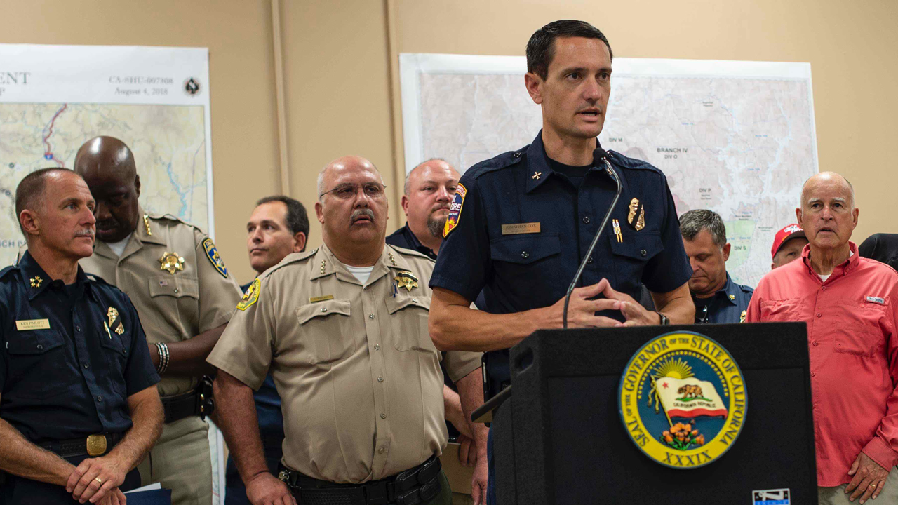
Fire Chief Jonathan Cox speaking at a press conference with Governor Brown regarding the Carr Fire in July 2018
Fire Chief Jonathan Cox speaks at a press conference with Governor Brown regarding the Carr Fire in July 2018. Image Courtesy of Cal Fire.

It's more than just a hunch that West Coast wildfires feel more intense these days. The California Department of Forestry and Fire Protection (or Cal Fire) reports that nine of the state's 20 most destructive wildfires in recorded history have happened since 2015. Almost all of those recent blazes raged in Northern California.

"This trajectory we're on in California is not sustainable," says alumnus Jonathan Cox (Agricultural Business '03). He has been on the front lines of many of those disasters as a firefighter, battalion chief and public information officer for Cal Fire in the Bay Area.

Cox got his start as a volunteer at Cal Fire's San Luis Obispo station just off Highland Drive near campus. The former Poly Rep would fight fires in the summer and on weekends, giving him a valuable "reality check" on what the real world is like outside of classes.

After nearly two decades with Cal Fire, Cox now serves as division chief, leading operations for San Mateo County Fire, where he is a trusted source for media from the containment lines. He has seen firsthand how the onslaught of major wildfires has converged with another seminal shift — how information flows through the digital landscape.

In years past, Cal Fire depended on traditional media to filter and distribute news from formal press conferences or statements to the community. Now Cox and many public information officers have embraced social media as a way to inform the public and the media simultaneously about rapidly changing conditions, evacuation orders and life-saving instructions.

A glance at Cox's Twitter account shows how his approach works. The feed serves as a hub for fire updates from around California. He shares insights from his post as command staff member for one of the state's six incident management teams, which take over once a major fire has overwhelmed local resources. He also acts as a spokesperson for Cal Fire when blazes ignite, providing context for media outlets locally and nationally.

With the power to inform thousands of residents with the click of a button, Cox doesn't take the responsibility lightly. He aims to be the public's advocate within Cal Fire while feeling the demands of accuracy and timeliness.

"You can't be callous with the information," says Cox. "It's just as important as putting the fire out. The way you present it and when you present it is paramount. If we don't keep the public up to date or informed or engaged, the trust can be lost very quickly."

The right information — like a red flag warning or road closures — can be the difference between life and death, Cox says. Take this example: the 1964 Hanley Fire burned from Calistoga to Santa Rosa in just over four days, charring fewer than 100 cabins in the process. In 2017, the Tubbs Fire burned the same area in three and a half hours, eventually destroying 5,500 homes and killing 22 people.

"I have two young daughters. On the Tubbs fire, it was about a week in, and I remember a father standing with his two daughters in front of their house that had been destroyed," recalls Cox. "I felt like I kept it together pretty well up until that point … and that [moment] kind of brought it all home."

While tracking the acceleration of these fires, Cox says Cal Fire has measured increased nighttime temperature and decreased degrees of moisture present in fuel like brush and trees. "Those indicators have both been going in the wrong direction," he notes. "For us it's undeniable that the changing climate is having an effect on how fires are behaving." Those conditions, paired with development sprawl in hard-to-defend geography, mean hundreds of communities stand face-to-face with possible disaster during a now year-round fire season.

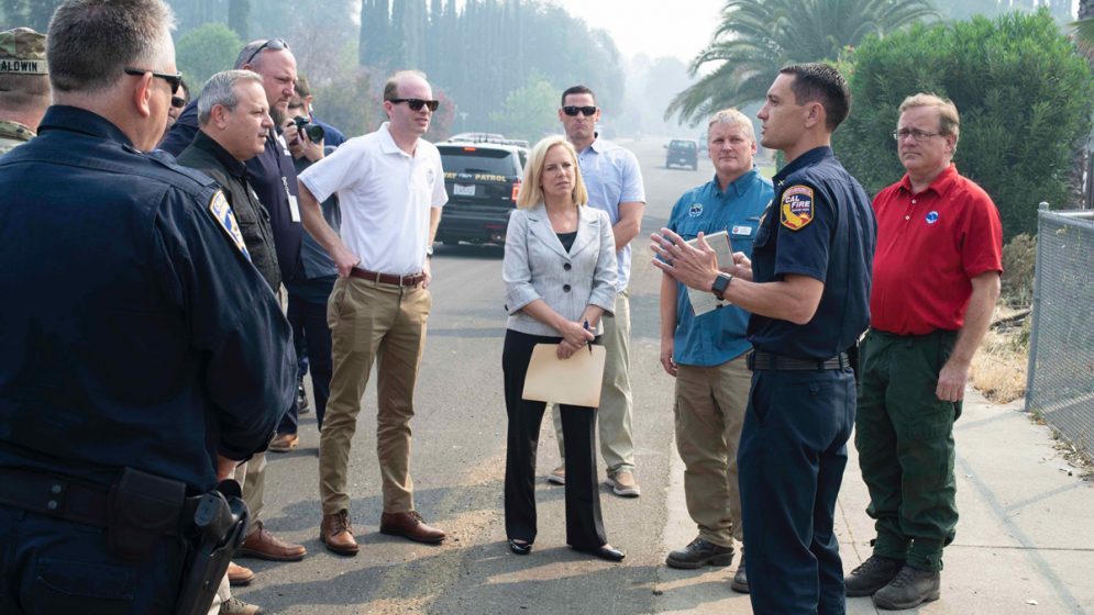
Fire Chief Jonathan Cox addresses leaders, including Homeland Security Secretary Kijrsten Nielsen, in Redding, CA, during the Carr Fire

Fire Chief Jonathan Cox addresses leaders, including former Homeland Security Secretary Kirstjen Nielsen, in Redding, CA, during the Carr Fire. Image courtesy of Cal Fire.

As blaze after blaze exhausts Californians, Cox knows his job is also to be a calm, steady force in moments of chaos. That's why he imagined himself as a firefighter even as a kid: to be an agent for good in his neighborhood.

"Early on in the North Bay fires, I had a reporter give me a huge hug and ask, 'Are we going to survive?' and I said 'Of course we're going to survive. Don't worry.'"

Cox has some reason to hope. He's excited by new technology — including sensors and cameras — that detect new blazes quickly. That information, along with more strategic evacuation management, will make a big difference in lives saved and damage prevented, Cox says.

In his own career, Cox still considers his alma mater the source of his success. "Cal Poly is the single biggest reason that so many good firefighters come out of San Luis Obispo County," he says, referring to experience he gained while still a student. "It was a launching pad for my life and my career in both friends and my profession."


--
_._,_._,_

Groups.io Links:

You receive all messages sent to this group.

View/Reply Online (#32399) | Reply To Group | Reply To Sender | Mute This Topic | New Topic

Your Subscription | Contact Group Owner | Unsubscribe [volcanomadness1@gmail.com]

_._,_._,_

[CaliforniaDisasters] A History Of California Wildfires [INTERACTIVE MAP]

See the perimeters of more than 100 years of California wildfires recorded by Cal Fire and the U.S. Geological Survey.

_._,_._,_

Groups.io Links:

You receive all messages sent to this group.
View/Reply Online (#32398) | Reply To Group | Reply To Sender | Mute This Topic | New Topic

Your Subscription | Contact Group Owner | Unsubscribe [volcanomadness1@gmail.com]

_._,_._,_