This Is Not A Crater, So What Is It?
Mika McKinnon
Circular landforms are intriguing. This is a naturally occurring feature, but was formed neither by a volcano nor a meteor. What is it?
Top image: Satellite image draped over a topographic model of Kondyor Massif, Russia. Credit: NASA/GSFC/METI/ERSDAC/JAROS, and U.S./Japan ASTER Science Team
This landform is just about as perfectly circular as a naturally-occurring landform can be, with a diameter just under 10 kilometres and a ridge about 600 meters tall. A river has cut through the lip, draining rainwater and runoff out of the center. The ridge is bare rock, with vegetation growing both inside and outside the ring. The image is a bit of a cheat: it's a satellite image draped over a topographical model to enhance dimensionality.
Crystals found at Kondyor Massif.
It's in northeastern Russia, and contains a truly impressive concentration of economically-interesting minerals. The minerals mix gold, silver, copper and lead with all sorts of trace elements. The aqueous solutions have distinct tinge of bismuth, tin, antimony, and tellurium, and the whole deposit is loaded with an abnormal proportion of noble metals like osmium. But the strangest component is large platinum-iron alloys with a golden crust. The crystals can get up to 1.5 centimeters in diameter.
Last chance to guess! The explanation is below the photo.
 Expand2
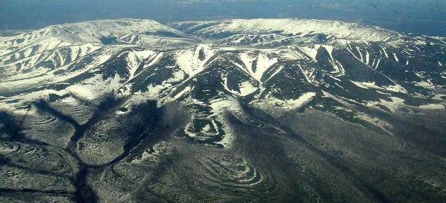
Oblique view of Kondyor Massif from a helicopter. Image credit: Mcvld
Kondyor Massif is an igneous intrusion, volcanic rock piercing the surrounding sedimentary rock without ever forming a volcano or erupting from a crater. A column originally topped by a dome when it formed, the structure has undergone differential erosion so the softer material weathered and eroded first, leaving the harder ring behind with the rest of the column hidden below the surface.
 Expand
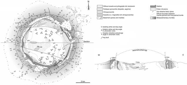
Geologic plan view and cross section of Kondyor Massif. Image credit: adapted from Burg et al (2008)
From gravity and magnetic surveys peering underground, the geophysics indicates this is a vertical column extending at least 10 kilometers deep into the crust. The geochemistry of the rock is ultramafic, which means the mineral makeup of the rock is low in silica, with a relatively high proportion of magnesium oxides and iron oxides. To add to the confusion, it's also likely that the column melted the surrounding rock while intruding, mixing in more minerals to mess with geologists interpreting its origin.
Now it's solidified, the column isn't the same throughout — it cooled more rapidly on the outside, producing smaller-grained crystals, and slower on the inside so crystals had the opportunity to grow larger. The feature also underwent fractional crystallization, with different minerals precipitating out first so that the outer ring is loaded with hornfels and pyroxenes while the center is more heavy in olivine and chromite. Just to prove that geology is really the dirtiest of sciences, one set of geoscientists describe the structure as an irregular 100 to 750 meter-wide aureole surrounding a 5.5 kilometer diameter dunite core, like some massive rocky inverted nipple.
The story of how a column of rock pushed through the crust is deceptively controversal. It all started as a reservoir of melt down in the lithosphere, heated by and mixed into a deep mantle plume which added in more exotic geochemical components. Some perturbation set off an instability, sending the volatile-rich melt rising up through the crust, melting and mixing in yet more minerals as it forced itself to the surface without forming a volcano or erupting through a crater.
 Expand3
If that sounds a little hand-wavy, that's about where the state of the science is: in their paper on the formation of Kondyor Massif, Burg and coauthors admit, "The mechanism that generated a vertical column of dense ultramafic rocks within the lithosphere nearly to the surface remains, however, enigmatic."
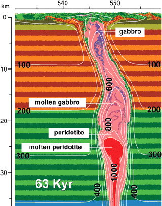
Cross section of numerical model of temperature distribution 63,000 years into teh formation of Kondyor Massif. Image credit: Burg et al (2008)
Their numerical models of the event suggest that the most likely mechanism is translithospheric diapirism: the ductile, deformable magma rose through a more solid, brittle crust after some perturbation started things off. That's the same concept that could explain why continents rift, or magmatic arcs split. However, that idea is contrary to how we think ultramafic materials move: it's weird for something so dense and gooey to start rising through overlaying material, even if it is experiencing geochemcial instability. An alternate mechanism is a relatively skinny feeder-dyke snaking up through the crust, bulging out into shallow disc below the surface. The problem with that is it doesn't align with the geophysical data that indicates a thicker subsurface column.
Kondyor Massif isn't a crater from an impact or a volcano: it's the top edge of a column of rock extending deep into the crust, and the remnants of partially-eroded dome. It's a source of valuable minerals, but most importantly of all, it's a beautiful glimpse of geomorphology drawing us into exploring and expanding our understanding of this mysterious planet and its places.
Ready for another non-crater circle of geologic awesome? Check out the Eye of the Saharahttp://space.io9.com/this-is-not-a-crater-so-what-is-it-1677228983
--
__._,_.___


No comments:
Post a Comment