Volcanic activity worldwide 14 Apr 2015: Kliuchevskoi volcano, Hekla
Hekla (Iceland): Small earthquake swarms occurred at shallow depths during the past days near the volcano. The quakes were located approx. 6-10 km south of Hekla volcano and at shallow depths around 5 km.
The largest quakes were two magnitude 2.6 events at 4 km depth on Thursday (9 April). It is impossible to say whether the earthquakes are linked to volcanic activity and thus might be precursors of a new eruption, but Hekla is probably the most likely candidate volcano for the next eruption to occur on Iceland.
One of the country's most active, and the most frequently erupting volcano, Hekla has been believed to be "due" and have its magma chamber filled for several years now. Known for not giving much precursory signals (and only few earthquakes), an eruption would not be a surprise at all.
Kliuchevskoi (Kamchatka): After less than two weeks pause, the volcano started to erupt again - mild strombolian explosions at the summit crater and small ash emissions.
KVERT raised the alert level again to yellow and noted that seismic activity has also shown an increase recently.
http://www.volcanodiscovery.com/volcano-activity/news/52536/Volcanic-activity-worldwide-14-Apr-2015-Kliuchevskoi-volcano-Hekla.html
__________________________________________________________________
 The crater of Mount Zao, which straddles Yamagata and Miyagi prefectures, is seen Monday after the Meteorological Agency warned of a possible eruption. Seismic activity has been growing on the peak since April 7. | KYODO
 Mount Zao may blow its top: agency
by Atsushi Kodera
Staff Writer
- Apr 14, 2015
Areas near Mount Zao rumbled with heightened seismic activity Tuesday after warnings that a potential eruption could threaten a popular Tohoku ski resort in the area were issued the previous day.
The volcano sits on the border of Miyagi and Yamagata prefectures, where 12 volcanic earthquakes had occurred by 11 a.m. Tuesday. The Meteorological Agency issued a volcanic warning the same day for areas around the crater — its first for the Zao area.
The agency warned the public to be on the lookout for falling rocks in areas within 1.2 km of the crater. The warning follows last year's deadly eruption of Mount Ontake, on the border of Gifu and Nagano prefectures. Ontake, which erupted without warning, ejected rocks, boulders and other debris over a wide area and was the worst volcanic disaster in the postwar era.
Ash and pebbles could reach even farther if carried by the wind, the agency warned.
Following the warning, issued at 1:30 p.m. Monday, notices warning of other potential hazards were set up at key points in the agency's area of responsibility, according to the Yamagata Prefectural Government. These included entrances to mountain trails, an observatory and a restaurant.
The agency advised nearby municipalities, including the towns of Zao, Shichikashuku and Kawasaki, all in Miyagi, and the cities of Yamagata and Kaminoyama in Yamagata, to raise alert levels in areas near the volcano.
With Ontake's eruption still fresh in people's minds, the latest warning quickly stoked fear in visitors, said a tourism association spokesman for the Zao ski and onsen resort.
"Okama is one of the key tourist spots in Zao," he said, referring to the color-changing lake in Zao's crater, "but people think the resort is already dangerous to enter, just because it has the same name as the volcano."
The association has been fielding calls since the warning was issued, presumably from people who plan to visit the area, which also attracts many hikers, the spokesman said.
According to the Meteorological Agency, seismic activity has been growing since April 7, leading it to the belief that a small eruption might be near. This prompted it to raise the warning level from "normal" to "dangers in areas around the crater."
As of Monday, volcanic quakes, or shallow seismic activity limited to the mountain and thought to originate from around the lake, continued to occur at a high frequency.
The quake tally this month had hit 182 as of 2 p.m. Monday, the agency said.
Japan has a total 110 active volcanoes.
The Coordinating Committee for the Prediction of Volcanic Eruptions, a panel administered by the agency, has identified 47 of these as requiring stepped-up monitoring for disaster prevention purposes.
Mount Zao is among them because it fits the pattern of having had periods of increased volcanic activity over the past 100 years.
The agency has four observation posts around the volcano. Cameras are set up at three of them, including the crater, while a seismograph and other measuring instruments have been installed at the fourth.
Mount Ontake erupted without warning on Sept. 27, shooting gas, rocks and ash into the air that killed 57 hikers. Six are still missing.
Ontake was also designated as a volcano requiring stepped-up monitoring because it has repeatedly erupted in the past few decades. Nevertheless, scientists failed to predict September's eruption.
____________________________________________________________________
All Quiet at Holuhraun
April 10, 2015


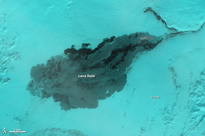
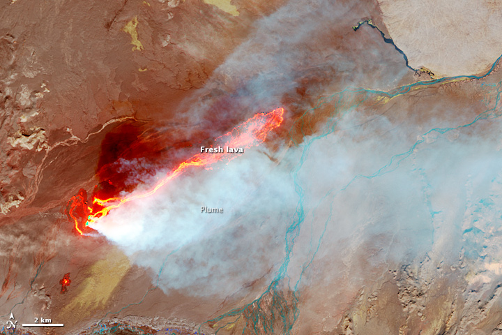
The Operational Land Imager (OLI) on Landsat 8 captured this pair of false-color images of the Holuhraun lava field. The images combine shortwave infrared, near infrared, and red light (OLI bands 6-5-4) to better show variations in the temperature of the lava. This particular band combination also makes it easier to see through the plume of steam and gas rising from the fissure.
In the image from April 2, 2015 (top), snow blanketed the surrounding landscape but the lava field (black) remained warm enough to prevent significant accumulation. For comparison, the second image shows Holuhraun on September 6, 2014, in the early days of the eruption. Newly-formed basaltic rock is black. Fresh lava is bright orange.
On February 28, 2015, Icelandic authorities declared the eruption over. Since August 2014, the eruption has produced a lava field that covers 85 square kilometers (33 square miles). The average thickness of the field is 10 to 14 meters (33 to 46 feet), and nearly 1.4 cubic kilometers (0.3 cubic miles) of lava (by volume) extruded from the Earth.
The eruption created a number of features—the lava field and several craters—that local authorities are now in the process of naming. A new lake will likely form when summer melt water runs off of nearby Vatnajökull glacier.
While fresh lava has stopped flowing from Holuhraun, it is possible that activity could resume. One volcanologist monitoring the area has noted that Bardarbunga's caldera, which fed the Holuhraun eruption, has started rising, a sign that magma may be accumulating in the magma chamber again.
Further Reading
- Icelandic Met Office (2015, March 15) The eruption has come to an end. Accessed April 8, 2015.
- Iceland Review (2015, March 10) Holuhraun. Accessed April 8, 2015.
- Wired (2015, March 9) Inside the Holuhraun Crater in Iceland. Accessed April 8, 2015.
NASA Earth Observatory image by Jesse Allen, using Landsat data from the U.S. Geological Survey. Caption by Adam Voiland.
- Instrument(s):
- Landsat 8 - OLI
______________________________________________________________________
Volcano Island of Taal
April 9, 2015

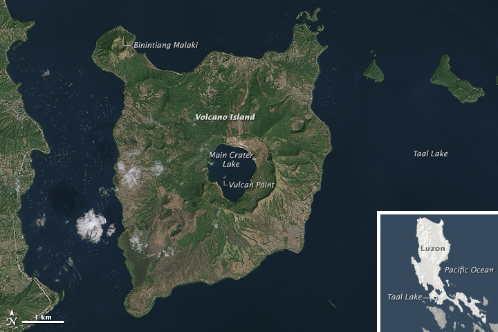
Taal volcano is complex. Instead of rising from the ground as a distinct, singular dome like its neighbor, Mayon, Taal consists of multiple stratovolcanoes, conical hills, and craters of all shapes and sizes. These features have grown together to form the 5-kilometer (3 mile) wide Volcano Island, one of the Philippines' most volcanically active areas.
The Operational Land Imager (OLI) on Landsat 8 acquired this image of Volcano Island on February 7, 2014. The island rises from the north-central side of Taal Lake, which in turn fills the much broader Taal caldera. (Click on the downloadable large image to see this wider context.)
All recorded eruptions from Taal have stemmed from Volcano Island. The southwest side of the island was the site of a violent two-day eruption in September 1965. The eruption was a 4 on the volcanic explosivity index (VEI), which ranges from 0 (small) to 8 (one million times more explosive than a VEI of 2). Early reports noted that as much as 4 meters (13 feet) of volcanic material fell at the southwest shoreline of the island. Smaller explosions in the 1970s formed cones and craters that have since reshaped the elongated 1965 crater.
Binintiang Malaki, the largest flank cone, is visible on the northwest side of the island at the end of an isthmus. This 263-meter-tall cone was formed during an eruption in 1707 that had a VEI of 2.
In the center of Volcano Island, Main Crater Lake fills the old crater floor. But one rocky remnant of that floor still emerges: Vulcan Point, which has the distinction of being among the world's largest islands in a lake on an island in a lake on an island. (The largest is actually a nameless isle within Victoria Island in Canada's Nunavut Territory.)
According to the Philippine Institute of Volcanology and Seismology (PHIVOLCS), activity at Taal was reported in 2008, 2010, and 2011. Increasing seismicity, followed by a rise in temperature of Main Crater Lake, led the alert level to be raised to 2 (on a scale of 0-5) in April 2011, but was lowered again that July.
Further Reading
- Geology.com (2015) Volcanic Explosivity Index. Accessed April 8, 2015.
- Moore, J. G. et al. (1966, February 25) The 1965 Eruption of Taal Volcano. Science, 151 (3713), 955-960.
- National Geographic Education, Ring of Fire.
- Smithsonian Institution Global Volcanism Program (2011) Taal. Accessed April 8, 2015.
NASA Earth Observatory images by Joshua Stevens, using Landsat data from the U.S. Geological Survey. Caption by Kathryn Hansen.
- Instrument(s):
- Landsat 8 - OLI
__._,_.___


No comments:
Post a Comment