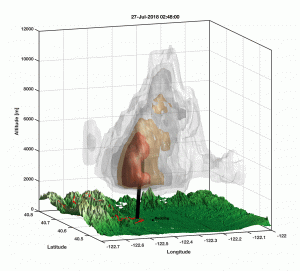
Scientists find causes of firenado in deadly Carr Fire
Posted by Sandra Ortellado
Climate, weather set the stage for uncontrollable inferno in Redding, California
By Mike Wolterbeek
A destructive fire-generated vortex – a massive stream of rising, spinning, smoke, ash and fire – that topped out at 17,000 feet above the earth, accelerated the Carr Fire that killed eight people and devastated a widespread area in the Redding, California region in July 2018. The vortex, a little-observed atmospheric phenomena, was spinning with the power of a class three tornado, which earned it the name of Firenado.
Atmospheric scientist in the Department of Physics Neil Lareau has authored a paper in Geophysical Research Letters, a journal of the American Geophysical Union, documenting the rare firenado, finding a number of factors that combined at just the right time and place to catalyze the deadly fire. These observations may help forecasters and scientists identify – and potentially warn – for future destructive fire-generated vortices.
"This paints a clear picture of the sequence of events leading to the vortex development and intensification," Lareau said. "This sequence suggests the Carr Fire vortex may qualify as pyro-genetic tornado, and not merely a tornado-strength fire-generated vortex."
In his study, satellite and radar observations document the evolution of the vortex revealing similarities to tornado dynamics. A key factor in the vortex formation was the development of a fire-generated ice-topped cloud (known as a pyro-cumulonimbus) which reached as high as 39,000 ft. The development of the cloud helped stretch the underlying column of air, concentrating the rotation near the surface and causing the tornado strength winds, estimated at 143 mph, the strength of an EF-3 tornado.
Radar data show that the vortex formed along the fire perimeter and within a pre-existing region of wind shear immediately following rapid vertical development of the convective plume, which grew from four to eight miles high in just 15 minutes. The plume development was fueled by the onset of the pyro-cumulonimbus cloud, a process similar to the development of an ordinary thunderstorm. It is this link to the cloud aloft that distinguishes the Carr fire vortex from more frequently observed fire-thirls, which tend to be smaller and less intense. The only other documented case of a "firenado" is during the Canberra Firestorm of 2003 in New South Wales, Australia.
The data in the study came from National Weather Service NEXRAD radars located at Beale Air Force Base, in northern California, Eureka, California and Medford, Oregon. While radar data has been used to study many other wildfires with pyro-cumulonimbus clouds, this is the first instance of NEXRAD radars observing the structure and evolution of a tornadic fire-generated vortex itself.
Other factors contributing to the firenado include:
• Exceptionally low fuel moisture due to unusual warmth throughout July.
• Climate impacts of a five-year drought followed by a near record wet season that produced an abundance of vegetation, then another exceptionally dry winter
• A near-surface cyclonic wind shear zone that developed in the hour prior to vortex formation
• The release of moist instability in the fire-generated cloud aloft
• Weather factors including very low humidity, record high temperatures, and terrain-channeled winds due to low atmospheric pressure.
The Carr Fire, which burned in Shasta and Trinity Counties, started July 23 after a tire blew out on a trailer and the rim made sparks on the pavement. It went on to burn 230,000 acres – 359 square miles – making it the seventh largest fire in California history. It was 100 percent contained by August 30.
The fire resulted in eight fatalities and destroyed 1,079 residences. Following ignition, the fire was initially terrain driven, spreading uphill from July 23 to July 25. Then, on July 26, the fire became wind-driven, advancing rapidly eastward and downhill into the western suburbs of Redding. The fire jumped the Sacramento River, and on the evening of July 26 the large fire-generated vortex formed along the northeastern flank of the fire. The fire-generated vortex was directly related to four deaths, numerous injuries and substantive loss of property.
"With the impacts from this fire, a discussion and studies are warranted about the potential to warn for future tornado-strength vortices," Lareau, an assistant professor in the Physics Department of the College of Science, said. "In this case, the availability of high resolution radar and satellite observations provide advance indications for vortex formation such that watches, or even warnings, may have been possible."
Forecasting Firenados
In the future, Lareau said, the operational meteorological and fire-fighting communities might develop routines to carefully inspect radar data for evidence of shear or rotation in wildfire plumes, and satellite data for indications of fire-cloud formations and storms.
Lareau's research specializes in mountain weather and wildfire plume dynamics and examines atmospheric dynamics across a range of scales. Other specific research topics includes, boundary-layer and cloud interactions, mountain valley cold air pools and synoptic-scale storm tracks.
Co-authors of the article are Nicholas Nausler of the NOAA/NWS/NCEP Storm Prediction Center in Norman, Oklahoma and John Abatzoglou from the Department of Geography at University of Idaho in Moscow, Idaho.
Funding for this work was provided, in part, by the National Science Foundation and the University of Nevada, Reno Research and Innovation Office.
The research article, "The Carr Fire Vortex: A Case of Pyrotornadogenesis?" was published in the American Geophysical Union's scientific journal Geophysical Research Letters.
Groups.io Links:
You receive all messages sent to this group.
View/Reply Online (#31974) | Reply To Group | Reply To Sender | Mute This Topic | New Topic
Your Subscription | Contact Group Owner | Unsubscribe [volcanomadness1@gmail.com]


No comments:
Post a Comment