California Disasters Upcoming Events
2002 Williams Fire Anniversary
When:
Sunday, 22 September 2019
Where:
San Gabriel Mountains - Los Angeles County
Organizer: Kim Patrick Noyes
Details:
The Williams Fire began its rampage near Williams Camp in the East Fork San Gabriel River above Glendora. By the time that fire was contained, it had charred 38,094 acres and destroyed 63 residences and 14 outbuildings. The Williams Fire burned into the remnants of the Curve Fire and became known as the Curve-Williams Complex, burning more than 58,951 combined acres.
Source: https://en.wikipedia.org/wiki/2002_California_wildfires and
https://danshikingblog.blogspot.com/2012/09/curve-fire-remembered-ten-years-later.html
2009 Guiberson Fire Anniversary
When:
Sunday, 22 September 2019
Where:
Santa Susana Mountains - Ventura County
Organizer: Kim Patrick Noyes
Details:
The Guiberson Fire was a wildfire that burned from September 22 until September 27, 2009 in Guiberson Canyon of the western Santa Susana Mountains, between Fillmore and Moorpark in Ventura County, California.
The Guiberson Fire, which started between Fillmore and Moorpark, caused the evacuation of almost 600 homes in Meridian Hills and Bardsdale with about 1,000 structures threatened, in addition to oil pipelines in the area. The cause of the fire is still unknown.
The fire destroyed an estimated 17,500 acres (71 km2), destroying an outbuilding and injuring 10 firefighters. On day two of the fire Governor Schwarzenegger declared a state of emergency.Source: https://en.wikipedia.org/wiki/Guiberson_Fire
1889 Santiago Canyon Fire Anniversary
When:
Tuesday, 24 September 2019
Where:
Peninsular Ranges - Orange, Riverside, & San Diego Counties
Organizer: Kim Patrick Noyes
Details:
The Santiago Canyon Fire of 1889 (previously called the Great Fire of 1889) was a massive wildfire in California, which burned large parts of Orange County, Riverside County, and San Diego County during the last week of September 1889. Until 2018, it was possibly the single largest wildfire in the recorded history of California, with at least 300,000 acres (1,200 km2) of land burned.[3] In mid-August 2018, the Ranch Fire in the Mendocino Complex Fire surpassed the Santiago Canyon Fire in size.
Assistant Regional Forester (USFS) L.A. Barrett, who wrote a 1935 report on California wildfires, said of it: "I was living in Orange County at the time and well remember the great fire reported herein from September 24 to 26. Nothing like it occurred in California since the National Forests have been administered. In fact in my 33 years in the Service I have never seen a forest or brush fire to equal it. This one covered an enormous scope of country and burned very rapidly."
Conditions leading up to the 1889 fire included a much longer and more severe annual drought than usual, with rains largely ceasing in March and less than 0.4 inches (1 cm) of precipitation being recorded for the 5½ months prior (records from the National Archives). This was coupled with multiple katabatic wind events (known as “northers” or Santa Anas) that month, one of which occurred about 10 days prior and likely added to the dryness of fuels. Temperatures during the week prior remained high and were coupled with several severe fires in San Diego County in which “at least 10,000 acres [40 km2] have burned over, a dwelling house consumed and other property destroyed”In addition to the Santiago Canyon Fire, there were several other significant fires fanned by the same gale force Santa Ana winds in San Diego and San Bernardino counties. The Santiago Canyon Fire was the largest and has been estimated as being greater than 308,000 acres (1,250 km2). Another wildfire in San Diego County at the time has been estimated to have been greater than 60,000 acres (240 km2). The Orange County fire burned through areas of chaparral and coastal sage scrub, as well as a number of farm fields in the Santa Ana Valley, where farmers attempted to control the fire by plowing ahead of it.[8] A detailed analysis of the fire can be found in an article by Keeley and Zedler.
Source: https://en.wikipedia.org/wiki/Santiago_Canyon_Fire
1978 PSA 182 Crash Anniversary
When:
Wednesday, 25 September 2019
Where:
San Diego - San Diego County
Organizer: Kim Patrick Noyes
Details:
Pacific Southwest Airlines (PSA) Flight 182 was a Boeing 727-214 commercial airliner, registration, N533PS that collided with a private Cessna 172 light aircraft, registration, N7711G over San Diego, California, at 9:01 am on Monday, September 25, 1978. It was Pacific Southwest Airlines' first fatal accident.
Both aircraft crashed into North Park, a San Diego neighborhood. Flight 182 impacted just north of the intersection of Dwight and Nile, killing all 135 people aboard the aircraft and seven people on the ground in houses, including two children. The Cessna impacted on Polk Ave. between 32nd St. and Iowa St. killing the two on board. Nine others on the ground were injured and 22 homes were destroyed or damaged by the impact and debris.
 PSA182 seconds after the collision with Cessna 172. | |
| Accident | |
|---|---|
| Date | 25 September 1978 |
| Summary | Mid-air collision resulting from pilot error and ATC error |
| Site | San Diego, California, United States |
| Total fatalities | 144 |
| Total injuries | 9 |
Source: https://en.wikipedia.org/wiki/PSA_Flight_182
1970 Clampitt Fire Anniversary
When:
Wednesday, 25 September 2019
Where:
Santa Susana Mountains - Los Angeles & Ventura Counties
Organizer: Kim Patrick Noyes
Details:
The Clampitt fire broke out around 8 a.m. Friday, Sept. 25, near Clampitt Road in the Newhall Pass as a result of downed power lines. In Santa Ana winds clocked at 80 mph, it took less than a day for the fire to make a 20-mile run to the coast, tearing through Porter Ranch, the Simi Hills at Chatsworth, south to the 101 Freeway and on to Malibu Canyon. News reports initially called it the Chatsworth-Malibu Canyon fire because much of the destruction occurred there.
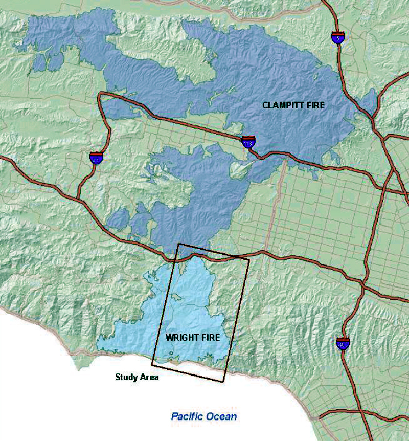 Burn area of the Clampitt (dark blue) and Wright (light blue) fires. Source: Master's thesis by Anthony D. Shafer, CSUN, May 2012. Click to enlarge. |
By the time the smoke cleared, the Clampitt Fire had scorched 107,103 acres of brush and forest, destroyed 80 structures killed four civilians (source: University of California Division of Agriculture and Natural Resources). It still stands as L.A. County's deadliest wildfire in modern history and was the largest until 2009 when the Station Fire, which claimed the lives of two firemen, passed it in acreage. (Giant fires of indeterminate size in the San Gabriel Mountains in 1896 and 1919 may have been bigger; see Robinson 1977.)
The Clampitt Fire encroached on the historic buildings of Mentryville in Pico Canyon where an inmate camp crew and a single fire engine were on hand to save the barns and corrals while the resident Lagasse family helped keep the flames away from Alex Mentry's 1890s mansion and various outbuildings. Most of the structures made similarly narrow escapes in August 1962 and October 2003 (the Wolcott barn was lost in the 1962 fire).
Meanwhile in Chatsworth, the fire leveled the old movie-set buildings of the Spahn Ranch, where Charles Manson and his "family" had been living in 1968 and 1969.
Source: https://scvhistory.com/gif/galleries/fire092570/
1993 Marre Fire Anniversary
When:
Wednesday, 25 September 2019
Where:
San Rafael Mountains - Santa Barbara County
Organizer: Kim Patrick Noyes
Details:
The Marre Fire started at approximately 3:30 pm on Saturday, September 25, 1993, on the Marre Ranch in the Los Padres National Forest. A hunter smoking a victory cigarette started the fire and was later charged with starting the fire and had to pay restitution.
Heavy fuels and high winds, coupled with low humidity, generated highly erratic fire behavior during the ensuing days. By September 27, the fire had burned 10,000+ acres of private and National Forest land. A Type 1 Incident Management Team, under the direction of Incident Commander Mike Dougherty, assumed command of the fire in a Unified Command structure with Santa Barbara County Fire Department. The Incident Commander for SBC was Division Chief Dan Gaither.
By September 30, the Marre Fire had burned approximately 32,500 acres, including a small portion of the San Rafael Wilderness. There were about 3,300 firefighters and support personnel assigned to the incident at this point. The west and south flanks of the fire appeared to be holding and the threat to private residences (including Michael Jackson's Neverland Ranch) was lessening. Early on the morning of Saturday, October 2, the fire jumped containment lines on the west flank, trapping several pieces of firefighting equipment and personnel in the process. From this point on, the northwest side of the fire, including Birabent Canyon and the Zaca drainage, became the area of greatest concern.
By Day 12, Thursday, October 7, 1993, the Marre Fire had burned approximately 42,700 acres, but the fire was 90% contained and heavy demobilization of firefighting resources was underway. On Friday, October 8, a Type 2 Incident Management Team took over command of the fire. Full containment was declared at 6 pm on that date.
Source: https://www.wildfirelessons.net/HigherLogic/System/DownloadDocumentFile.ashx?DocumentFileKey=4f339ee5-4eb4-485c-9916-a88c60e2b964
1970 Wright Fire Anniversary
When:
Wednesday, 25 September 2019
Where:
Santa Monica Mountains - Los Angeles County
Organizer: Kim Patrick Noyes
Details:
The Wright (Malibu) Fire began on Sept. 25, 1970, in the Santa Monica Mountains along the Hwy 101 corridor and burned over the Santa Monica Mountains to the coast. The Wright Fire charred 27,925 acres and destroyed 103 homes (source: UCANR).
Source: https://scvhistory.com/gif/galleries/fire092570/
1970 Laguna Fire Anniversary
When:
Thursday, 26 September 2019
Where:
Peninsular Ranges - San Diego County
Organizer: Kim Patrick Noyes
Details:
The Laguna Fire, previously known as the Kitchen Creek Fire and the Boulder Oaks Fire, occurred in 1970 in the Laguna Mountains and East County region of San Diego County in Southern California, United States.
The Laguna fire was started by downed power lines during Santa Ana winds in the Kitchen Creek area of the Laguna Mountains on the morning of September 26, 1970. In only 24 hours, it burned westward about 30 miles (48 km) to the outskirts of El Cajon and Spring Valley. The fire devastated the communities of Harbison Canyon and Crest. In the end, the fire burned 175,425 acres (709.92 km2) and 382 homes, killing 16 people.
The Laguna Fire was surpassed as the third-largest fire in California history by the 280,278-acre (1,134.24 km2) Cedar Fire in October 2003. It was surpassed as the fourth-largest by the 197,990-acre (801.2 km2) Witch Creek Fire in October 2007.
Source: https://en.wikipedia.org/wiki/Laguna_Fire1997 Williams Fire Anniversary
When:
Friday, 27 September 2019
Where:
Sierra Nevada Foothills - Yuba County
Organizer: Kim Patrick Noyes
Details:
The Williams Fire, a 5,743 acre fire started at approximately 3:04 pm on Saturday, September 27, 1997. The cause of the fire was determined to be an electrical short in a motor home. Operational resources fighting the fire were supplied by Cal Fire, USFS, and numerous Fire Districts and municipalities. Foresters from CHY Timber and Soper Wheeler were contacted to provide maps, air photos, and to help with contingency planning. Timber landowners used their own equipment to open old roads along the north side of the fire. Before the fire was contained 186 engines, 45 hand crews, 27 dozers, 21 water tenders, 6 helicopters, 7 air tankers and 201 overhead personnel were assigned to the incident. The impact to the residents and communities was immeasurable with 91 housing structures, 136 out buildings and 184 vehicles destroyed. A mass evacuation was begun Saturday with traffic control and check points in place on the 27th, 28th and 29th. At 10:00 am Monday affected residents were allowed re-entry.
Source: http://dohfd.com/Dobbins%20OH%20History2.html
2004 Parkfield Quake Anniversary
When:
Saturday, 28 September 2019
Where:
Cholame Valley - Monterey/San Luis Obispo Counties
Organizer: Kim Patrick Noyes
Details:
The 6.0 magnitude primary shock in 2004 was the result of a fault movement of about 18 inches (.5 meter). There have been no indications found that could have been used to predict this earthquake. Although well overdue, the probability of this quake occurring in 2004 has been estimated at about ten percent. The magnitude of the event was consistent with previous earthquakes in this region.
Substantial aftershocks continued for more than a week after the initial event, moving in a northwesterly progression. In early October, there was a cluster of small earthquakes near Paso Robles near a parallel fault to the west. These may be in response to the transfer of stress to these faults after the release of stress at Parkfield. Past earthquakes have also occurred to the east of Parkfield at about the same distance from the San Andreas fault near Coalinga and Avenal.
Source: https://en.wikipedia.org/wiki/Parkfield_earthquake#2004_event
Groups.io Links:
You receive all messages sent to this group.
View/Reply Online (#32338) | Reply To Group | Reply To Sender | Mute This Topic | New Topic
Mute #cal-summary
Your Subscription | Contact Group Owner | Unsubscribe [volcanomadness1@gmail.com]
No comments:
Post a Comment