California Disasters Upcoming Events
1997 Williams Fire Anniversary
When:
Friday, 27 September 2019
Where:
Sierra Nevada Foothills - Yuba County
Organizer: Kim Patrick Noyes
Details:
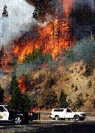
The Williams Fire, a 5,743 acre fire started at approximately 3:04 pm on Saturday, September 27, 1997. The cause of the fire was determined to be an electrical short in a motor home. Operational resources fighting the fire were supplied by Cal Fire, USFS, and numerous Fire Districts and municipalities. Foresters from CHY Timber and Soper Wheeler were contacted to provide maps, air photos, and to help with contingency planning. Timber landowners used their own equipment to open old roads along the north side of the fire. Before the fire was contained 186 engines, 45 hand crews, 27 dozers, 21 water tenders, 6 helicopters, 7 air tankers and 201 overhead personnel were assigned to the incident. The impact to the residents and communities was immeasurable with 91 housing structures, 136 out buildings and 184 vehicles destroyed. A mass evacuation was begun Saturday with traffic control and check points in place on the 27th, 28th and 29th. At 10:00 am Monday affected residents were allowed re-entry.
Source: http://dohfd.com/Dobbins%20OH%20History2.html
2004 Parkfield Quake Anniversary
When:
Saturday, 28 September 2019
Where:
Cholame Valley - Monterey/San Luis Obispo Counties
Organizer: Kim Patrick Noyes
Details:
The 6.0 magnitude primary shock in 2004 was the result of a fault movement of about 18 inches (.5 meter). There have been no indications found that could have been used to predict this earthquake. Although well overdue, the probability of this quake occurring in 2004 has been estimated at about ten percent. The magnitude of the event was consistent with previous earthquakes in this region.
Substantial aftershocks continued for more than a week after the initial event, moving in a northwesterly progression. In early October, there was a cluster of small earthquakes near Paso Robles near a parallel fault to the west. These may be in response to the transfer of stress to these faults after the release of stress at Parkfield. Past earthquakes have also occurred to the east of Parkfield at about the same distance from the San Andreas fault near Coalinga and Avenal.
Source: https://en.wikipedia.org/wiki/Parkfield_earthquake#2004_event
1999 Gun 2 Fire Anniversary
When:
Saturday, 28 September 2019
Where:
Cascade Mountains - Shasta County
Organizer: Kim Patrick Noyes
Details:
The Gun 2 Fire began on September 28, 1999, in Shasta County east of Redding and over the following week charred 60,390 acres of forest land.
2005 Topanga Fire Anniversary
When:
Saturday, 28 September 2019
Where:
Santa Susana Mountains to Conejo Valley - Ventura County
Organizer: Kim Patrick Noyes
Details:
The Topanga Fire was a wildfire that ignited on September 28, 2005 in the Santa Susana Mountains, to the northwest of Chatsworth and the San Fernando Valley in Southern California.
The Topanga Fire burned a total of 24,175 acres (97.8 km2), injured 31 people, and cost $15.8 million to fight. The wildfire grew to more than 16,000 acres (65 km²) in 2 days, threatening homes, natural resources, power lines, and communications equipment in the Simi Hills, in eastern Ventura County, as well as the Conejo Valley region north of the Santa Monica Mountains.
Experts foresaw the problem as Southern California entered the hottest part of the fire season, with the land covered in brush that grew after the heaviest rains in over 100 years. Although the wind, dry conditions, and steep terrain made the work of firefighters difficult, the loss of property had been low (as of early October); according to news reports from Friday, September 30, one home and handful of outbuildings had been lost. Mandatory evacuations were in place, involving at least 1,500 residents of the area.
On October 2, 2005, over 17,000 acres (69 km²) were burned. Furthermore, only 5% of the blaze was estimated to have been contained by the approximately 3,000 firefighters battling it. On October 6, the Topanga Fire was 100% contained, after it had expanded to 24,175 acres (97.8 km2).
Source: https://en.wikipedia.org/wiki/Topanga_Fire
1992 Cleveland Fire Anniversary
When:
Sunday, 29 September 2019
Where:
Sierra Nevada - El Dorado County
Organizer: Kim Patrick Noyes
Details:
The Cleveland Fire began on a hot and breezy Fall afternoon. A small five-foot diameter fire was reported at noon on September 29 in the vicinity of the Cleveland Corral Visitor Information Station, eight miles east of Pollock Pines.
|
The Cleveland fire burned aggressively for the first three days, burning 4,500 acres the first day and almost 14,000 acres the second day. On the third day, tragedy struck and a fire retardant tanker plane crashed. Two pilots gave their lives that day while trying to stop the aggressively moving fire. Fortunately, after burning another 3,500 acres that day, it began to lightly rain in the evening. It was another 13 days before the fire was declared controlled, on October 14, 1992 at a total size of 22,485 acres. Half of the burned area was public land and the majority of the rest was private commercial timberland.
In all, some 5,300 firefighters and support personnel from over 130 different cooperating agencies and groups worked on the fire. The fire was terribly costly. Besides the two lives lost and the millions of dollars of timber resources consumed in the fire, 41 dwellings and several outbuildings, and several pieces of logging and construction equipment were burned. In addition, the El Dorado Canal, supplying water to the local communities of Pollock Pines and Camino, was severely damaged. Highway 50, the main travel route to South Lake Tahoe, was closed for several weeks resulting in losses in regional economic revenue. The environmental costs were also tremendous. The fire killed almost all trees over most of the fire area, immediately removing wildlife habitat for forest dwelling animals and increasing the stress on fragile watersheds.
Source: http://eldoradocounty.net/clevelandfire.html
1987 Whittier Narrows Quake Anniversary
When:
Tuesday, 1 October 2019
Where:
San Gabriel Valley - Los Angeles County
Organizer: Kim Patrick Noyes
Details:
The 1987 Whittier Narrows earthquake occurred in the southern San Gabriel Valley and surrounding communities of southern California at 7:42 a.m. PDT on October 1. The moderate 5.9 magnitude blind thrust earthquake was centered several miles north of Whittier in the town of Rosemead, had a relatively shallow depth, and was felt throughout southern California and southern Nevada. A large number of homes and businesses were impacted, along with roadway disruptions, mainly in Los Angeles and Orange counties. Damage estimates ranged from $213–358 million, with 200 injuries, three directly-related deaths, and five additional fatalities that were associated with the event.
Source: https://en.wikipedia.org/wiki/1987_Whittier_Narrows_earthquake
1943 Hauser Fire Anniversary
When:
Wednesday, 2 October 2019
Where:
Peninsular Ranges - San Diego County
Organizer: Kim Patrick Noyes
Details:
The Hauser Fire was started by tracer rounds fired in a military training exercise. 77 Marines from the Pine Valley training camp and the 10th Army Buffalo Soldiers Cavalry Regiment from Camp Lockett fought the fire on 10/2/43, building indirect handline in a steep drainage. When the strong Santa Anas (E winds) diminished, the normal canyon SW winds increased, reversing the direction of the fire and pushing the marines up into Hauser Canyon. Their retreat to a safe area was cut off. Almost all were caught and injured; 4 outran the fire. 9 Marines and 1 Army soldier (and possibly 1 civilian) were overrun and died. The remaining troops were injured to various degrees. 16,000 acres were scorched and San Diego's water supply was threatened.
Source: https://wlfalwaysremember.org/incident-lists/169-hauser-creek.html
1995 Mt. Vision Fire Anniversary
When:
Thursday, 3 October 2019
Where:
Point Reyes Peninsula - Marin County
Organizer: Kim Patrick Noyes
Details:
The Mount Vision Fire was a wildfire that burned 12,354 acres (50 km2) of land on the Point Reyes National Seashore peninsula in northern California during October 1995. The fire, which was started by an incompletely extinguished campfire, destroyed 45 homes in Inverness Park.
Source: https://en.wikipedia.org/wiki/Mount_Vision_Fire
1933 Griffith Park Fire Anniversary
When:
Thursday, 3 October 2019
Where:
Hollywood Hills - Los Angeles County
Organizer: Kim Patrick Noyes
Details:
The 1933 Griffith Park Fire was a brush fire that occurred on 3 October 1933 in Griffith Park in Los Angeles, resulting in the deaths of at least 29 civilians who were trying to fight the fire. It was one of the deadliest firefighter disasters in United States history.
During the dry summer and fall of 1933, thousands of workers financed by the Reconstruction Finance Corporation were hired to clear dry brush and to build trails and roads in Griffith Park. On October 3, 1933, an estimated 3,780 men were working in the park, for a pay of 40 cents an hour. More than 100 squads of 50 to 80 men were at work in the park, each supervised by a foreman or "straw boss".
A little after 2 p.m., a small fire started in a pile of debris in Mineral Wells Canyon. Many of the workers volunteered or were ordered to fight the fire, but it spread up the canyon. Because there was no piped water in the area, the men tried to beat out the fire with shovels. Foremen with no knowledge of firefighting initially directed the effort, setting inappropriate back fires and sending hundreds of workers into a steep canyon. The fire department arrived at 2:26 p.m. but found it hard to fight the fire because of the presence of thousands of untrained people. When the wind changed direction at about 3 p.m., the fire rushed up Dam Canyon, jumped a hastily constructed firebreak, and advanced on the workers, killing dozens and injuring more than 100. By nightfall the fire was under control, after burning about 47 acres (19 ha) of the park's 4,200 acres.
Because of the disorganized nature of the deployment and the often inaccurate recordkeeping of the work project, it took weeks to establish the exact death toll and identify the bodies. A month after the fire, the District Attorney's office put the official death toll at 29, with 27 dead at the scene and two dead in hospitals afterwards. The Griffith Park fire remained the single-deadliest fire in California history for 85 years until being surpassed by the Camp Fire in 2018, which killed at least 83 people. The cause of the fire was never fully determined.
To commemorate the dead workers, a deodar tree was planted at the entrance to the park along with a memorial plaque. The plaque can no longer be found.Source: https://en.wikipedia.org/wiki/1933_Griffith_Park_Fire
2017 Redwood Valley Complex Anniversary
When:
Tuesday, 8 October 2019
Where:
Potter Valley & Redwood Valley - Mendocino County
Organizer: Kim Patrick Noyes
Details:
The Redwood Complex Fire, which started on October 8, 2017, was the result of two fires merging — the Potter Valley and Redwood Valley fires. The Potter Valley fire started at approximately 10:35 p.m. in northwest Mendocino County and joined a second fire that ignited at approximately 1:30 a.m. on October 9. Because of the steep terrain, fuel moistures, and northwest winds the fire blazed for 21 days and was not fully contained until October 28, 2017.
Unfortunately, the consequences of the fire have been devastating for Mendocino County neighborhoods and business districts.
- 36,523 acres burned
- 545 structures were destroyed
- 43 structures were badly damaged
- 8,000 people were forced to evacuate the area
- Hundreds of animals were relocated, including dozens of dogs and cats, and 50 horses
- Schools in the Ukiah Unified, Potter Valley and Willits Unified districts were closed
Most tragic, the fire has caused the loss of life and serious injuries. To date, nine deaths have been reported, ranging in age from 14 to 88. Additionally, more than 20 individuals have been hospitalized with severe burns.
Below is a map showing the far-reaching scope of the fire and communities is has impacted.

Groups.io Links:
You receive all messages sent to this group.
View/Reply Online (#32384) | Reply To Group | Reply To Sender | Mute This Topic | New Topic
Mute #cal-summary
Your Subscription | Contact Group Owner | Unsubscribe [volcanomadness1@gmail.com]
No comments:
Post a Comment