Debris flow on Boulder Glacier

June 2016. The gray streak down the center is a flow of ice and rock on the Boulder Glacier on the east slope of Mount Baker. Can't determine from the photo how much further the debris flow extends. Sherman Peak is the pointed summit at left. Photo taken from Boulder Ridge around 4600′ elevation. Thanks to Corey Vannoy for this view. Click to enlarge images.
Reader Corey Vannoy reports a recent debris flow that swept down Mount Baker's Boulder Glacier. He climbed this route over the weekend (June 4-5, 2016) and sent two photos. There have been no other reports of this event. If anyone else has descriptions or photos, either from the ground or aerial, please send to MBVRC. This may be the first Boulder Glacier debris flow since October 2013.

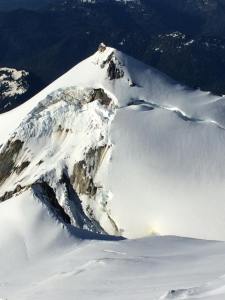
June 2016. Release zone on the north flank of Sherman Peak on Mount Baker. Periodic ice avalanches extend to rock below, which is incorporated into a debris flow that sweeps down the Boulder Glacier to the east (left). Compare with photos from other years in the link in the text. Photo courtesy Corey Vannoy.
Debris flows initiate every few years in the same place on the north slope of Sherman Peak. Go here to read a report on this website about these hazardous events.
--
__._,_.___

No comments:
Post a Comment