California Disasters Upcoming Events
2014 King Fire Anniversary
When:
Friday, 13 September 2019
Where:
Sierra Nevada - El Dorado County
Organizer: Kim Patrick Noyes
Details:
The King Fire was a wildfire that scorched over 97,000 acres (390 km2) of land in El Dorado County, California in the fall of 2014. The fire, which was named because it started off King of the Mountain Road in Pollock Pines, started on September 13, 2014 near Pollock Pines, California, to the east of Sacramento.
On September 16, three days after starting, the fire had spread to 11,520 acres (46.6 km2) forcing the evacuation of over five hundred homes A handcrew of 10 inmates and a Fire Captain were saved from being overrun when they were led to safety by a helicopter that was staged at the nearby Swansboro Country Airport. By September 18, the fire had expanded to 73,184 acres (296.17 km2), becoming the second largest wildfire of the 2014 California wildfire season. As a result of this growth, the mandatory evacuation order was expanded to 20,000 homes.
By the start of October the fire had grown to 97,099 acres (392.95 km2) with containment increasing to 94%. On October 9, the perimeter of the King Fire was reported to be 100% contained, with a final acreage of 97,717 acres (395.45 km2). During the following days, pockets of fire continued burning deep inside the containment lines.
On October 10, the closure area was reduced, as additional progress was made. During the next several days, the wildfire was diminished further, as the weather in the region entered a cooling trend. The King Fire injured a total of twelve people and caused the evacuation of nearly 3,000 people in the area.
The King Fire has destroyed 12 singles residences and 68 other residential structures, but the amount of damage caused by the wildfire is currently unknown.Source: https://en.wikipedia.org/wiki/King_Fire
2000 Harris Fire Anniversary
When:
Friday, 13 September 2019
Where:
Vandenberg Air Force Base - Santa Barbara County
Organizer: Kim Patrick Noyes
Details:
The Harris Fire began on September 13, 2000, off Harris Grade Road in the Lompoc Oilfield as a result of an electrical fire involving inadequate brush clearance and pushed by unusual southeast winds drove the fire onto the post of Vandenberg Air Force Base and down into Santa Antonio Valley and fatefully into Barka Slough which features a peat bog. This bog feature proceeded to catch fire and burn for the next year and frantic efforts failed to quench the malodorous smoky bog fire for several months. Large monitors/water cannons were brought in and over additional months finally quenched the fire. 9,700 acres were charred.
2014 Boles Fire Anniversary
When:
Sunday, 15 September 2019
Where:
Weed - Siskiyou County
Organizer: Kim Patrick Noyes
Details:
The Boles Fire was a wildfire that burned in Siskiyou County during mid-September 2014. On September 15, at 1:38 PM PDT, the Boles Fire ignited near Weed, California. At 10:30 PM PDT, later on the same day, the Boles Fire was reported at 350 acres and 15% containment. Over 100 structures were reported damaged or destroyed on that day. Later that day, the wildfire was reported at nearly 100% containment; however, this report turned out to be erroneous. On September 16, the Boles Fire had burned 375 acres (152 ha) and was only 20% contained. It also destroyed 150 residences and forced the evacuation of 1,500 people in Weed and Siskiyou County.
During the next couple of days, the Boles Fire increased to 479 acres (194 ha), before finally being fully contained on September 20. The wildfire also caused 1 injury. The Boles Fire destroyed a total of 150 residential structures and 8 nonresidential commercial properties, while damaging 4 single residences and 3 nonresidential commercial properties. The damage caused by the Boles Fire is currently unknown. The cause of the wildfire was reported as "under investigation."
Ronald Beau Marshall was charged with arson in the Boles Fire case. As of December 5, 2014, Marshall was subject to a preliminary hearing in the matter. In 2015, Ronald Beau Marshall received 3 years for starting the fire. In 2016, Marshall was released from prison.Source: https://en.wikipedia.org/wiki/Boles_Fire
2016 Canyon Fire Anniversary
When:
Tuesday, 17 September 2019
Where:
Vandenberg Air Force Base - Santa Barbara County
Organizer: Kim Patrick Noyes
Details:
The Canyon Fire was a wildfire that burned on Vandenberg Air Force Base in Santa Barbara County, California during September 2016. By the time the fire was contained on September 24, it had burned 12,742 acres (51.6 km2) of land. Due to the nature of the activities that take place on the Base, there were a number of unique challenges posed during the fire including the presence of potentially hazardous materials.
The fire broke out September 17 and quickly grew to over 500 acres (2.0 km2). Due to the location of the fire, burning in a remote canyon on the southern half of the base, access was difficult for fire crews. On September 18 the fire jumped to over 2,200 acres (8.9 km2) prompting evacuation warnings for homes on San Miguelito Canyon south of Lompoc and east of the base. By mid-afternoon on September 19 the fire had grown to over 4,528 acres (18.3 km2) and with no containment was continuing to burn with a moderate rate of spread.
As the fire continued to spread, firefighters were faced with a number of unique challenges. Base officials warned that there was possibly unexploded ordnance that was left over from the days when the base was used during World War II and the Korean War.[3] By the morning of September 20, the fire had been estimated at 10,542 acres (42.7 km2) in size with only 18% of the fire contained.
On September 21, a Ventura County OES water tender assigned to the fire crashed on Highway 246 just outside Lompoc. The crash killed one firefighter and sent the second to the hospital with minor injuries. The individual was identified as engineer Ryan Osler.
The fire was fully contained on September 24 after burning 12,742 acres (51.6 km2).Source: https://en.wikipedia.org/wiki/Canyon_Fire_(2016)
1923 Berkeley Fire Anniversary
When:
Tuesday, 17 September 2019
Where:
Berkeley Hills - Alameda County
Organizer: Kim Patrick Noyes
Details:
The 1923 Berkeley Fire was a conflagration that consumed some 640 structures, including 584 homes in the densely-built neighborhoods north of the campus of the University of California in Berkeley, California on September 17, 1923.
Although the exact cause was never determined, the fire began in the undeveloped chaparral and grasslands of Wildcat Canyon, just east of the ridgeline of the Berkeley Hills, and was propelled over the ridge and southwestward just south of Codornices Creek by a strong, gusty, and intensely dry northeasterly wind. The fire quickly blew up as it swept through the La Loma Park and Northside neighborhoods of Berkeley, overwhelming the capabilities of the Berkeley Fire Department to stop it. A number of UC students fought the advance of the fire as it approached the north edge of the University of California campus, at Hearst Avenue. The other edge of the fire was fought by firefighters as it advanced on downtown Berkeley along the east side of Shattuck Avenue north of University Avenue. Firefighters were rushed in from neighboring Oakland, and San Francisco sent firefighters by ferry across the bay.
Firefighting efforts were hampered by the inadequacy of water mains in northern Berkeley, where rapid development after the 1906 San Francisco earthquake had outgrown the water supply in the fire area. Firefighters trying to fight the fire connected to hydrants in the area that hissed dry and were hampered also by the predominance of cedar shake roofs. The strong and dry wind lifted burning shakes off burning houses and quickly spread the fire. The fire was halted only when the northeasterly winds died down and were replaced by the cool, humid afternoon sea breeze. The fire lines were established at Hearst and Shattuck Avenues, where larger diameter water mains delivered a reliable water supply for firefighting.
Building styles in North Berkeley changed dramatically after the 1923 fire, with stucco and tile roof homes largely, but not entirely, replacing the wood-sided and cedar-shaked construction styles popularized by the Berkeley Hillside Club before the fire.
As a belated result of the fire, the City of Berkeley constructed a fire station in the hills at 2931 Shasta Road (at Queens Road) just below Grizzly Peak Blvd, in 1948. In the early 2000s, this station was replaced and relocated to a nearby site just above Grizzly Peak Blvd. at 3000 Shasta Road, on the interface between the residential area and Tilden Regional Park, very close to the putative origin of the 1923 fire.
Source: https://en.wikipedia.org/wiki/1923_Berkeley,_California_fire
2009 Guiberson Fire Anniversary
When:
Sunday, 22 September 2019
Where:
Santa Susana Mountains - Ventura County
Organizer: Kim Patrick Noyes
Details:
The Guiberson Fire was a wildfire that burned from September 22 until September 27, 2009 in Guiberson Canyon of the western Santa Susana Mountains, between Fillmore and Moorpark in Ventura County, California.
The Guiberson Fire, which started between Fillmore and Moorpark, caused the evacuation of almost 600 homes in Meridian Hills and Bardsdale with about 1,000 structures threatened, in addition to oil pipelines in the area. The cause of the fire is still unknown.
The fire destroyed an estimated 17,500 acres (71 km2), destroying an outbuilding and injuring 10 firefighters. On day two of the fire Governor Schwarzenegger declared a state of emergency.Source: https://en.wikipedia.org/wiki/Guiberson_Fire
2002 Williams Fire Anniversary
When:
Sunday, 22 September 2019
Where:
San Gabriel Mountains - Los Angeles County
Organizer: Kim Patrick Noyes
Details:
The Williams Fire began its rampage near Williams Camp in the East Fork San Gabriel River above Glendora. By the time that fire was contained, it had charred 38,094 acres and destroyed 63 residences and 14 outbuildings. The Williams Fire burned into the remnants of the Curve Fire and became known as the Curve-Williams Complex, burning more than 58,951 combined acres.
Source: https://en.wikipedia.org/wiki/2002_California_wildfires and
https://danshikingblog.blogspot.com/2012/09/curve-fire-remembered-ten-years-later.html
1889 Santiago Canyon Fire Anniversary
When:
Tuesday, 24 September 2019
Where:
Peninsular Ranges - Orange, Riverside, & San Diego Counties
Organizer: Kim Patrick Noyes
Details:
The Santiago Canyon Fire of 1889 (previously called the Great Fire of 1889) was a massive wildfire in California, which burned large parts of Orange County, Riverside County, and San Diego County during the last week of September 1889. Until 2018, it was possibly the single largest wildfire in the recorded history of California, with at least 300,000 acres (1,200 km2) of land burned.[3] In mid-August 2018, the Ranch Fire in the Mendocino Complex Fire surpassed the Santiago Canyon Fire in size.
Assistant Regional Forester (USFS) L.A. Barrett, who wrote a 1935 report on California wildfires, said of it: "I was living in Orange County at the time and well remember the great fire reported herein from September 24 to 26. Nothing like it occurred in California since the National Forests have been administered. In fact in my 33 years in the Service I have never seen a forest or brush fire to equal it. This one covered an enormous scope of country and burned very rapidly."
Conditions leading up to the 1889 fire included a much longer and more severe annual drought than usual, with rains largely ceasing in March and less than 0.4 inches (1 cm) of precipitation being recorded for the 5½ months prior (records from the National Archives). This was coupled with multiple katabatic wind events (known as “northers” or Santa Anas) that month, one of which occurred about 10 days prior and likely added to the dryness of fuels. Temperatures during the week prior remained high and were coupled with several severe fires in San Diego County in which “at least 10,000 acres [40 km2] have burned over, a dwelling house consumed and other property destroyed”In addition to the Santiago Canyon Fire, there were several other significant fires fanned by the same gale force Santa Ana winds in San Diego and San Bernardino counties. The Santiago Canyon Fire was the largest and has been estimated as being greater than 308,000 acres (1,250 km2). Another wildfire in San Diego County at the time has been estimated to have been greater than 60,000 acres (240 km2). The Orange County fire burned through areas of chaparral and coastal sage scrub, as well as a number of farm fields in the Santa Ana Valley, where farmers attempted to control the fire by plowing ahead of it.[8] A detailed analysis of the fire can be found in an article by Keeley and Zedler.
Source: https://en.wikipedia.org/wiki/Santiago_Canyon_Fire
1993 Marre Fire Anniversary
When:
Wednesday, 25 September 2019
Where:
San Rafael Mountains - Santa Barbara County
Organizer: Kim Patrick Noyes
Details:
The Marre Fire started at approximately 3:30 pm on Saturday, September 25, 1993, on the Marre Ranch in the Los Padres National Forest. A hunter smoking a victory cigarette started the fire and was later charged with starting the fire and had to pay restitution.
Heavy fuels and high winds, coupled with low humidity, generated highly erratic fire behavior during the ensuing days. By September 27, the fire had burned 10,000+ acres of private and National Forest land. A Type 1 Incident Management Team, under the direction of Incident Commander Mike Dougherty, assumed command of the fire in a Unified Command structure with Santa Barbara County Fire Department. The Incident Commander for SBC was Division Chief Dan Gaither.
By September 30, the Marre Fire had burned approximately 32,500 acres, including a small portion of the San Rafael Wilderness. There were about 3,300 firefighters and support personnel assigned to the incident at this point. The west and south flanks of the fire appeared to be holding and the threat to private residences (including Michael Jackson's Neverland Ranch) was lessening. Early on the morning of Saturday, October 2, the fire jumped containment lines on the west flank, trapping several pieces of firefighting equipment and personnel in the process. From this point on, the northwest side of the fire, including Birabent Canyon and the Zaca drainage, became the area of greatest concern.
By Day 12, Thursday, October 7, 1993, the Marre Fire had burned approximately 42,700 acres, but the fire was 90% contained and heavy demobilization of firefighting resources was underway. On Friday, October 8, a Type 2 Incident Management Team took over command of the fire. Full containment was declared at 6 pm on that date.
Source: https://www.wildfirelessons.net/HigherLogic/System/DownloadDocumentFile.ashx?DocumentFileKey=4f339ee5-4eb4-485c-9916-a88c60e2b964
1970 Clampitt Fire Anniversary
When:
Wednesday, 25 September 2019
Where:
Santa Susana Mountains - Los Angeles & Ventura Counties
Organizer: Kim Patrick Noyes
Details:
The Clampitt fire broke out around 8 a.m. Friday, Sept. 25, near Clampitt Road in the Newhall Pass as a result of downed power lines. In Santa Ana winds clocked at 80 mph, it took less than a day for the fire to make a 20-mile run to the coast, tearing through Porter Ranch, the Simi Hills at Chatsworth, south to the 101 Freeway and on to Malibu Canyon. News reports initially called it the Chatsworth-Malibu Canyon fire because much of the destruction occurred there.
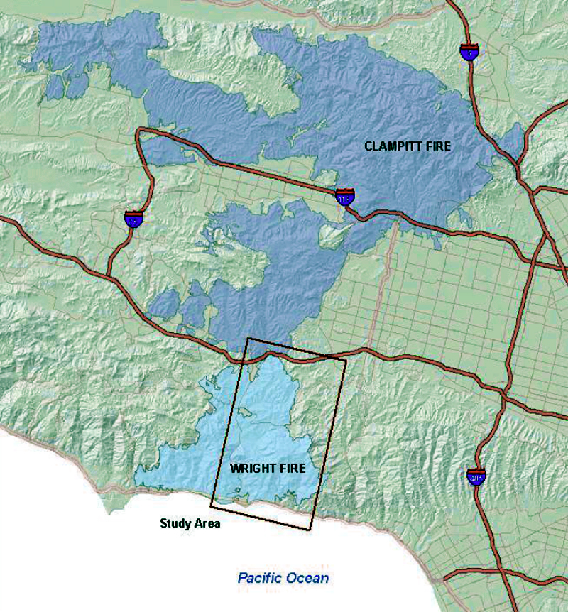 Burn area of the Clampitt (dark blue) and Wright (light blue) fires. Source: Master's thesis by Anthony D. Shafer, CSUN, May 2012. Click to enlarge. |
By the time the smoke cleared, the Clampitt Fire had scorched 107,103 acres of brush and forest, destroyed 80 structures killed four civilians (source: University of California Division of Agriculture and Natural Resources). It still stands as L.A. County's deadliest wildfire in modern history and was the largest until 2009 when the Station Fire, which claimed the lives of two firemen, passed it in acreage. (Giant fires of indeterminate size in the San Gabriel Mountains in 1896 and 1919 may have been bigger; see Robinson 1977.)
The Clampitt Fire encroached on the historic buildings of Mentryville in Pico Canyon where an inmate camp crew and a single fire engine were on hand to save the barns and corrals while the resident Lagasse family helped keep the flames away from Alex Mentry's 1890s mansion and various outbuildings. Most of the structures made similarly narrow escapes in August 1962 and October 2003 (the Wolcott barn was lost in the 1962 fire).
Meanwhile in Chatsworth, the fire leveled the old movie-set buildings of the Spahn Ranch, where Charles Manson and his "family" had been living in 1968 and 1969.
Source: https://scvhistory.com/gif/galleries/fire092570/
Groups.io Links:
You receive all messages sent to this group.
View/Reply Online (#32297) | Reply To Group | Reply To Sender | Mute This Topic | New Topic
Mute #cal-summary
Your Subscription | Contact Group Owner | Unsubscribe [volcanomadness1@gmail.com]
No comments:
Post a Comment