Small earthquake near the Big Bend of the San Andreas Fault
By David Jacobson, Temblor

Last night, at 9:14 p.m. local time, a M=3.5 earthquake struck just north of the San Andreas Fault in Southern California. The quake's epicenter was 5 km north of Frazier Park and near Tejon Pass on Interstate-5. While not large enough to cause damage, the earthquake did result in moderate shaking near the epicenter and approximately 150 reported feeling the quake on the USGS website. This earthquake occurred at an extremely shallow depth and was pure strike-slip in nature.

Because the epicenter of this quake was nearly 5 km from the main strand of the San Andreas, it likely did not occur on it. This idea is also supported by the fact that the two focal mechanism planes are not parallel with either the San Andreas, or the nearby Garlock faults. However, it should be pointed out that these planes are more optimally oriented, given the principle stress directions. So, while not on the main strands of either of these large faults, the structure on which last night's earthquake occurred, could be associated with them.
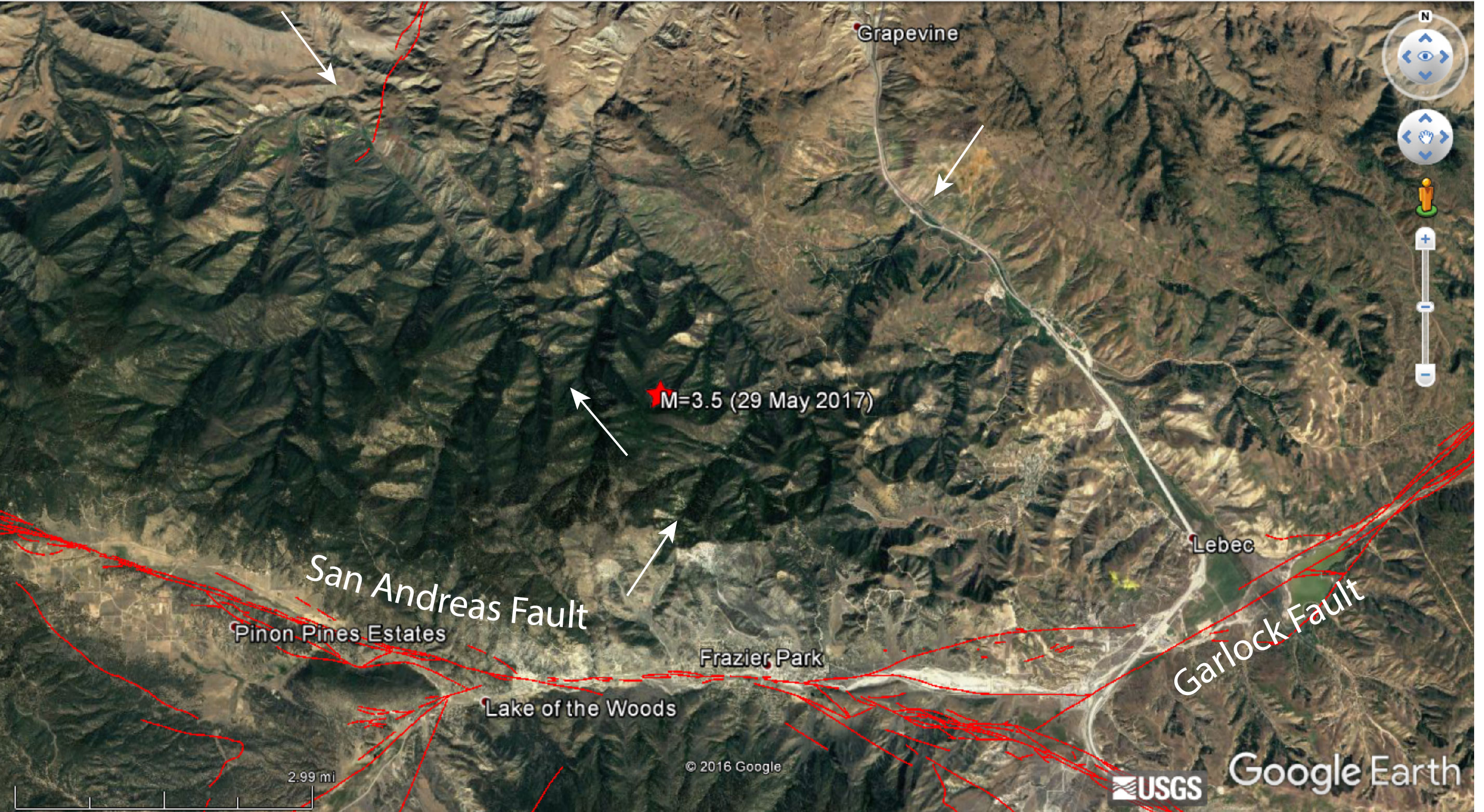
What this very small earthquake also highlights is potentially unmapped faults in the vicinity of the Big Bend section of the San Andreas. When a fault cannot relieve tectonic forces acting on it (such as when it is not optimally oriented), there have to be other faults that take accommodate it. In the Google Earth image below, the area around yesterday's earthquake is shown. While the San Andreas and Garlock faults are clearly mapped, there are extremely straight valleys, which have similar orientations to the focal mechanism of yesterday's quake.
Even though this earthquake likely didn't originate on the San Andreas, it is important to highlight this section of the fault given the potential for a large earthquake. Additionally, in Southern California, the Big Bend and adjacent Carrizo and Mojave sections of the San Andreas accommodate 50-70% of plate motion, meaning there is a very high seismic hazard. In a paper by Dr. Katherine Scharer at the USGS that was published earlier this year, she and her team found new evidence of at least 10 ground-rupturing earthquakes prior to the 1857 M=7.7-7.9 Fort Tejon earthquake along the Big Bend section of the Southern San Andreas Fault. In this paper, they determined that the average interval between earthquakes on the Big Bend section is approximately 100 years, with some as short as 22 years and as long as 186 years noted. Furthermore, 66% of the intervals are shorter than the current one, which sits at 160 years.
While we are not saying that a large earthquake along this section of the San Andreas is going to happen soon, based on historical seismicity, it is an area that is seen as more likely to rupture in a large earthquake than other parts of the San Andreas. Therefore, highlighting it and informing people of the seismic risk is vital to ensuring that when an earthquake does happen we can be are prepared as possible.

References
USGS
Scharer, K., R. Weldon, G. Biasi, A. Streig, and T. Fumal (2017), Ground-rupturing earthquakes on the northern Big Bend of the San Andreas Fault, California, 800 A.D. to present, J. Geophys. Res. Solid Earth, 122, doi:10.1002/2016JB013606. Link
--
__._,_.___
No comments:
Post a Comment