What would a powerful earthquake feel like where you live?
How this works
This map shows what may be among the worst case scenarios of shaking you could feel at a particular address. Downtown Long Beach, for instance, would feel severe shaking from a plausible magnitude 7.2 quake on the Newport-Inglewood fault, which runs through the city. By contrast, the magnitude 8 scenario we chose to map on the southern San Andreas fault — about 50 miles away — would bring strong shaking to downtown Long Beach.
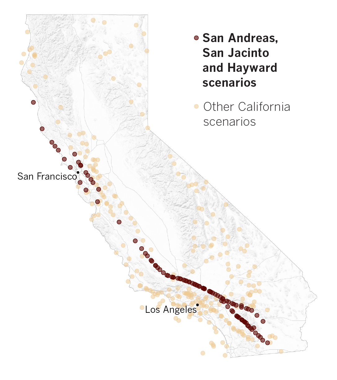
There may be worse shaking scenarios possible than the ones we illustrated above. To keep the interactive map running fast, we chose just 14 out of more than 300 earthquake scenarios available for the California area.
Some earthquake scenarios are more likely to occur in our lifetime than others. If you want to see what can happen in your part of California, look at this map showing the relative earthquake shaking potential across the state.
Fastest-moving faults
There are roughly 30,000 miles of faults cutting across California, but the three fault sections that most concern many seismologists are the San Andreas, San Jacinto and Hayward. As they continue to build up seismic stress, ruptures become more and more likely. These faults are located near the Bay Area and Los Angeles, and big earthquakes on them could potentially displace hundreds of thousands of people.
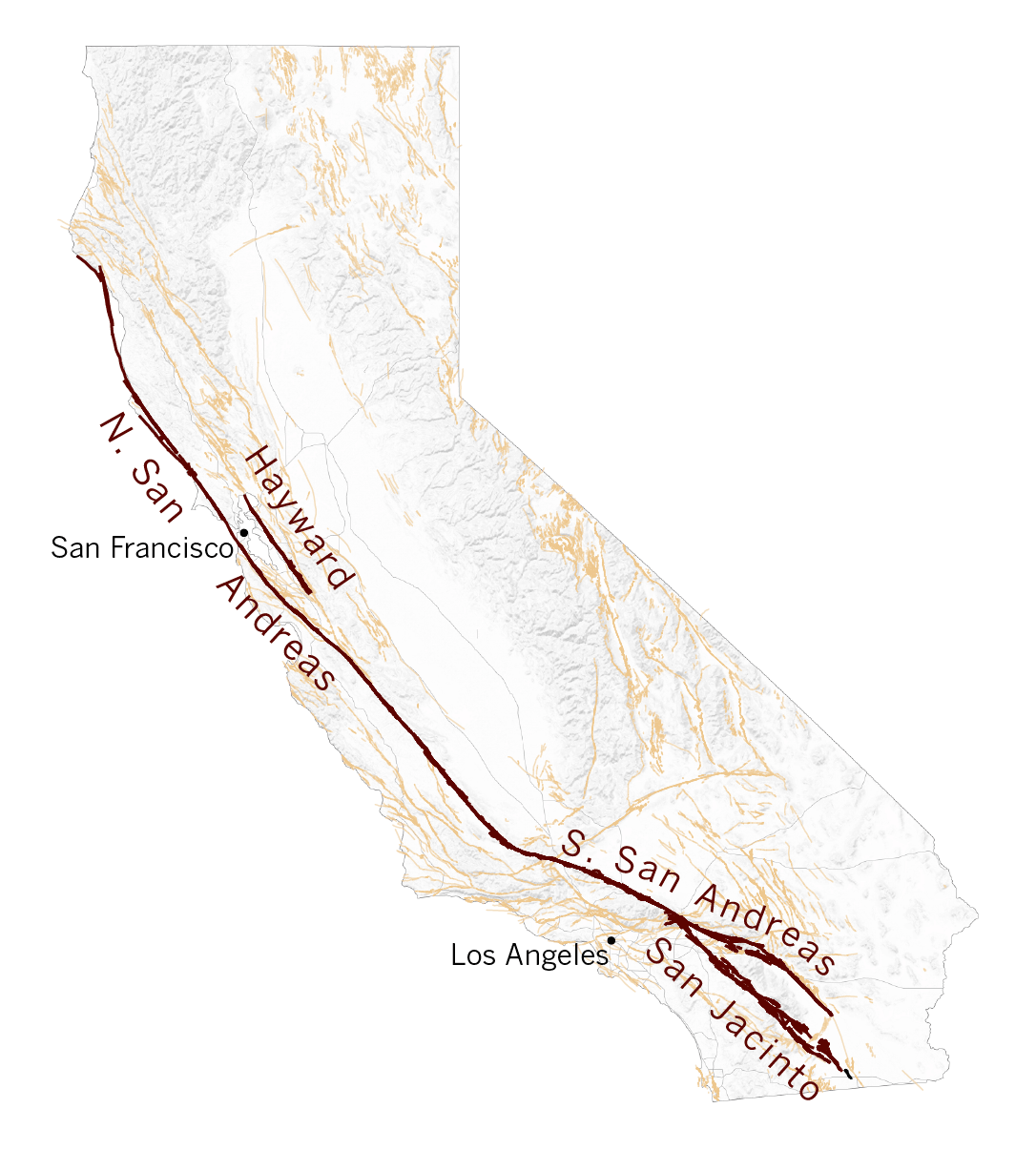
The data for this project comes from the 2014 National Seismic Hazard fault database, published every six years by the USGS. This database contains nearly 800 scenarios, of which more than 300 take place within California's borders or along the coast.
To produce these scenarios, the USGS evaluates the likelihood of earthquakes on active faults across the country. Each earthquake scenario estimates shaking intensities for affected populations by assuming a certain magnitude, location, fault-rupture geometry, and then factoring in other variables like geology and local site soil conditions. These scenarios are most often utilized by emergency response organizations, utilities and local governments to prepare for realistic earthquake response situations.
Damage scenarios
What kind of damage could a big California earthquakes bring? Here's a sampling of various scenarios studied by officials:
- Southern San Andreas fault (Southern California), magnitude 7.8: 1,800 dead, 50,000 injured, $200 billion in damage, more than 250,000 displaced from homes (scenario website).
- Hayward fault (Bay Area), magnitude 7: 800 dead, 18,000 injured, 400 fires, more than 400,000 displaced from homes.
- Puente Hills Thrust fault (Southern California), magnitude 7.5: 18,000 dead, $250 billion in damage if it occurred on a weekday afternoon.
- Palos Verdes fault (Southern California), magnitude 7.3: 200 dead, 2,000 buildings destroyed, could liquefy artificial land underneath the nation's largest port complex.
Preparing for the Big One
Although seismologists cannot predict when or where the next big earthquake will hit, it is essential to prepare for the worst. Read the linked articles below for steps you can take today:
- When The Big One hits, will you be ready? Take our quiz to be sure
- Earthquake preparedness: What to do before — and during — a big one
- The 9 earthquake hazards lurking in your home
- Need an emergency kit list? Take this pro's advice
- Your instinct may be to run outside during an earthquake. Here's why you shouldn't
- Earthquake preparedness tips — for your pets: How to keep them safe
- 2 quakes in 2 days, no warning from ShakeAlertLA. Now the app is getting reworked
Scenarios used
Relatively more likely scenarios
- Northern San Andreas fault, M8.0
- Southern San Andreas fault, M8.0
- Hayward fault, M7.1
- Santa Monica-Hollywood fault, M6.8
- Newport-Inglewood fault, M7.2
- Cascadia Megathrust, M9.3
- Rose Canyon fault, M7.0
- San Jacinto fault, M7.8
- Rodgers Creek and Healdsburg faults, M7.2
- Calaveras fault, M7.0
- San Gregorio fault, M7.4
Rarer scenarios
- Palos Verdes fault, M7.4
- Puente Hills thrust fault, M7.0
- Great Valley fault, M7.3
Times staff writer Rong-Gong Lin II also contributed to this report.
--

Groups.io Links:
You receive all messages sent to this group.
View/Reply Online (#32096) | Reply To Group | Reply To Sender | Mute This Topic | New Topic
Your Subscription | Contact Group Owner | Unsubscribe [volcanomadness1@gmail.com]
No comments:
Post a Comment